
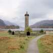
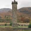
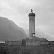
Glenfinnan Monument


Commemorative Monument (19th Century)
Site Name Glenfinnan Monument
Classification Commemorative Monument (19th Century)
Alternative Name(s) Glenfinnan, Prince Charlie's Monument; Loch Shiel
Canmore ID 23339
Site Number NM98SW 1
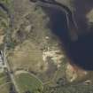
NGR NM 90616 80575
Datum OSGB36 - NGR
Permalink http://canmore.org.uk/site/23339


- Council Highland
- Parish Arisaig And Moidart
- Former Region Highland
- Former District Lochaber
- Former County Inverness-shire
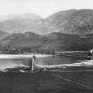
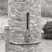
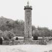
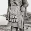
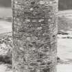
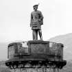
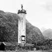
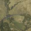
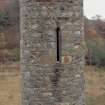
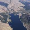
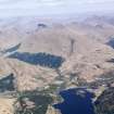
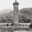
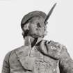
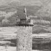
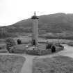
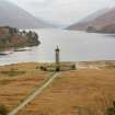
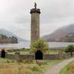
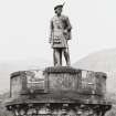
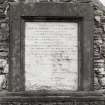
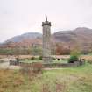
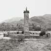
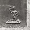
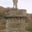
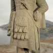
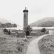
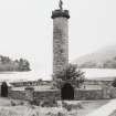
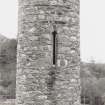
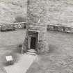
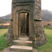
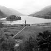
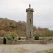
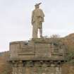
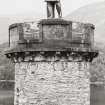
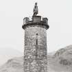
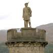
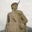
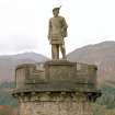
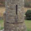
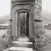
Glenfinnan Monument, James Gillespie Graham, 1813 -15 A folly in a sublime landscape standing close to the site at the head of Loch Shiel where the Jacobite standard was raised in August 1745. It was built by Alexander Macdonald of Glenaladale as a crenellated tower with internal spiral stair and abutting 'shooting box'. The latter was demolished in 1834 and the tower transformed into a public monument commemorating those who 'fought and bled in that arduous and unfortunate enterprise'. It became a column supporting the stone figure of a Highlander, carved by John Greenshields of Carluke. For more on the Macdonalds of Glenaladale.
Taken from "Western Seaboard: An Illustrated Architectural Guide", by Mary Miers, 2008. Published by the Rutland Press http://www.rias.org.uk

NM98SW 1.00 90616 80575
Glenfinnan Monument
(National Trust for Scotland) [NAT]
OS (GIS) MasterMap, November 2010.
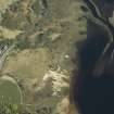
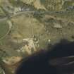
Not to be confused with the traditional site of the raising of the Jacobite standard (incised rock surface at NM 9038 8096), for which see NM98SW 9.
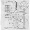
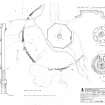
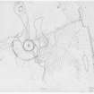
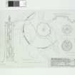
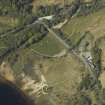
NM 906 805 Excavations took place in the surroundings of the monument in order to ascertain the nature of a roughly concentric wall known to have been in existence around the monument during the 1820s, and also to investigate the footings to a building which formed part of the monument early in its life. Scant remains of a wooden beam foundation to the adjoining building were recorded, although this was not conclusive.
Investigation of the wall showed it to be of drystone construction, consisting of rough blocks and generally surviving to one course high. It extended over 180 degrees around the monument, and more may survive under an area of raised beach.
Sponsor: National Trust for Scotland
D Hind 1998.
NM 906 805 An engraving of the monument dating to the 1820s records the existence of a two-storey 'shooting box' built as an original part of the structure. A proposal to plant clan-emblem trees in the western half of the stockaded area around the monument gave rise to an excavation to discover the exact site of the shooting box. The results would ensure that the pits for the trees would not damage or disturb any foundation remains.
The excavation, to the W of the current path to the door of the monument, revealed the foundations of the W corner of the shooting box, the structure having its corners at the W, N and E, and abutting the monument to the S. The foundations are 1.2m wide, defining a structure at least 4m NW-SE by 6m SW-NE over its walls.
Archive to be deposited in the NMRS.
Sponsor: NTS.
J Harden 2002
NM 9051 8070 Bald's Estate Plan of Ardnamurchan and Sunart shows this to have been the site where Prince Charles Edward Stuart raised the Standard on 16 August 1745. A rapid walkover survey showed nothing of archaeological interest other than a considerable area or rig and furrow cultivation, some field dykes and the burial ground at NM 9060 8064.
Sponsor: Sunart Oakwoods Research Group.
J E Kirby 2003.
NM98SW 1.00 90616 80575
NM98SW 1.01 NM 90748 80677
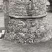
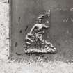
Sculptor: James or John Greenshields 1815 - figure of kilted highlander
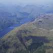
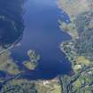
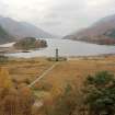
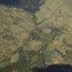
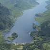
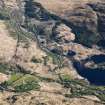
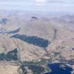
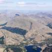
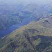
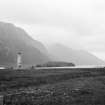
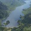
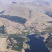
The Glenfinnan Monument, now in the care of the National Trust for Scotland, is one of the principal symbols of Highland Jacobite culture. Set at the head of Loch Shiel, it marks the place at or near which the Jacobite standard was raised in 1745 to signal the start of the uprising led by Prince Charles Edward Stuart. Despite its fame as a Jacobite symbol, other aspects of the Monument have been overlooked, including the circumstances of its patronage by a local landowner with an instinct for excess, its history as a structure and the fact it was the work of one of the foremost Scottish Architects of the first half of the 19th century, James Gillespie Graham. More speculatively, it is also argued here that its dramatic relationship to its topographical setting marks it out as a key monument of the Romantic period.
Information from RCAHMS (NMC) 1999
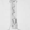
Non-Guardianship Sites Plan Collection, DC23833, 1930
Excavation (1 January 1998 - 31 December 1998)
Excavations took places in the surroundings of the monument in order to ascertain the nature of a roughly concentric wall known to have been in existence around the monument in the 1820s, and also to investigate the footings of a building which formed part of the monument early in its life.
D Hind, National Trust for Scotland 1998
Note (1999)
The Glenfinnan Monument, now in the care of the National Trust for Scotland, is one of the principal symbols of Highland Jacobite culture. Set at the head of Loch Shiel, it marks the place at or near which the Jacobite standard was raised in 1745 to signal the start of the uprising led by Prince Charles Edward Stuart. Despite its fame as a Jacobite symbol, other aspects of the Monument have been overlooked, including the circumstances of its patronage by a local landowner with an instinct for excess, its history as a structure and the fact it was the work of one of the foremost Scottish Architects of the first half of the 19th century, James Gillespie Graham. More speculatively, it is also argued here that its dramatic relationship to its topographical setting marks it out as a key monument of the Romantic period.
Information from RCAHMS (NMC) 1999
Excavation (1 January 2002 - 31 December 2002)
NM 906 805 An engraving of the monument dating to the 1820s records the existence of a two-storey 'shooting box' built as an original part of the structure. A proposal to plant clan-emblem trees in the western half of the stockaded area around the monument gave rise to an excavation to discover the exact site of the shooting box. The results would ensure that the pits for the trees would not damage or disturb any foundation remains.
The excavation, to the W of the current path to the door of the monument, revealed the foundations of the W corner of the shooting box, the structure having its corners at the W, N and E, and abutting the monument to the S. The foundations are 1.2m wide, defining a structure at least 4m NW-SE by 6m SW-NE over its walls.
Archive to be deposited in the NMRS.
Field Visit (1 January 2003 - 31 December 2003)
NM 9051 8070 Bald's Estate Plan of Ardnamurchan and Sunart shows this to have been the site where Prince Charles Edward Stuart raised the Standard on 16 August 1745. A rapid walkover survey showed nothing of archaeological interest other than a considerable area or rig and furrow cultivation, some field dykes and the burial ground at NM 9060 8064.
Sponsor: Sunart Oakwoods Research Group.
J E Kirby 2003.

