
Pricing Change
New pricing for orders of material from this site will come into place shortly. Charges for supply of digital images, digitisation on demand, prints and licensing will be altered.
Stones Of Stenness


Henge (Neolithic) - (Bronze Age), Stone Circle (Neolithic) - (Bronze Age)
Site Name Stones Of Stenness
Classification Henge (Neolithic) - (Bronze Age), Stone Circle (Neolithic) - (Bronze Age)
Alternative Name(s) Ring Of Stenness; Standing Stones Of Stenness; Temple Of The Sun
Canmore ID 2105
Site Number HY31SW 2
NGR HY 3067 1252
Datum OSGB36 - NGR
Permalink http://canmore.org.uk/site/2105


First 100 images shown. See the Collections panel (below) for a link to all digital images.
- Council Orkney Islands
- Parish Stenness
- Former Region Orkney Islands Area
- Former District Orkney
- Former County Orkney
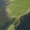
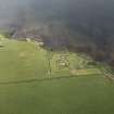
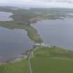
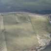
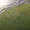
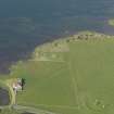
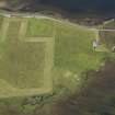
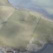
The Stones of Stenness comprise five uprights in a circle that, originally, probably held twelve stones. They stand within a bank and ditch with one entrance, a type of monument known as a henge. The ditch represents a considerable investment of labour, as it is 45m in diameter, over 7m wide and cut into bedrock to a depth of over 2m. Radiocarbon dating of bones found in the ditch demonstrate that the site was in use in the early 3rd millennium BC, a similar period to the nearby monuments of Maes Howe, the Ring of Brodgar and the settlements of Barnhouse and Skara Brae.
Information from RCAHMS (SC) 14 August 2007
Ritchie, A and Ritchie, G 1991
HY31SW 2 3067 1252
See also HY31SW 11 and HY31SW 12.
(HY 3067 1252) Standing Stones (NR)
OS 6" map, Orkney, 2nd ed., (1903).
The 'Ring of Stenness' (V G Childe and W D Simpson 1961) or 'Stones of Stenness' (RCAHMS 1946), a Class II henge (F W Wainwright 1962), under Ministry of Works guardianship.
As far as can be ascertained this monument originally consisted of a series of standing stones set around the upper margin of a flat-topped mound, outside which, at a distance of about 18-20ft from the lower margin, was a circular bank approximately 234ft in external diameter. The bank and ditch (which divides it from the mound) have been obliterated by cultivation.
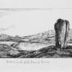
The monument now consists of three monoliths, 15 to 17ft high, and the stump of a fourth, 6ft 3ins high, set around the western arc of a circle 104ft in diameter. An altar-like construction in the middle is 'a modern and wholly fanciful addition'.
Information from RCAHMS (JH), 2 March 1966.
RCAHMS 1946.
The Ring of Stenness (As named on the Historic Buildings and Monuments sign), a Class II henge, is generally as described and planned by the above authorities. The stump of a fifth monolith is visible on the north side and the outer bank is traceable in part, along the north and west arcs, by a slight ridge and soil-discolouration in the adjacent ploughed field. The entrances shown on the Commission plan No. 377 (RCAHMS 1946) are not visible.
Resurveyed at 1/2500.
Visited by OS (NKB) 5 May 1966.
RCAHMS 1946.
An early third millenium BC henge and stone circle. Two of the stones and one of the outlying stones were deliberately destroyed in the early 19th century. Excavation revealed the bedding-holes for other stones, and it is likely that there were originally twelve stones set in a cricle about 30m in diameter. Ploughing has all but levelled the henge earthworks.
Bones of cattle, sheep and dog were found in the bottom of the ditch, along with one human finger-bone, and radiocarbon analysis of these finds indicates that the henge was built in the early 3rd millenium BC.
Two outlying stones are likely to have some connection with the henge, the Watch Stone (HY31SW 11) and the Barnhouse Stone (HY31SW 12).
A Ritchie 1996
Holes measuring 800 x 700mm and 180-230mm deep were dug for plaques at three sites in the parish of Stenness, Mainland Orkney. One hole was located near the Ring of Brogar (HY 2946 1346; HY21SE 1), one at the Stones of Stenness (HY 3071 1239; HY21SW 2) and one at Maes Howe (HY 3180 1272). Nothing of archaeological significance was discovered in any of the holes.
Sponsor: Historic Scotland
P Sharman 2000
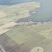
A geophysical survey using magnetometry was undertaken in and around the Heart of Neolithic Orkney World Heritage Site between June and October 2002. Over 30ha was surveyed, including the Ring of Brodgar, the fields to the S of the Stones of Stenness (including Big Howe, HY31SW 31), an area around Bookan chambered cairn, and the fields between Brodgar Farm and the Bridge of Brodgar. Preliminary results have clarified the extent of known sites and discovered several new ones.
Archive to be deposited in Orkney SMR and the NMRS.
Sponsors: HS, Orkney Islands Council, Orkney Archaeology Trust, Orkney College.
N Card 2002.
World Heritage Area; Geophysical survey
N Card (OAT)
A second season of magnetometry survey was undertaken in and around the Heart of Neolithic Orkney World Heritage SIte. Over 30ha was surveyed, further clarifying the extent of known sites and locating many new ones. Further survey in the immediate environs of The Ring of Brodgar seemed to emphasise the lack of magnetic enhancement in this area. This is in marked contrast to the area around the Stones of Stenness and on the Ness of Brodgar.
Report to be lodged with Orkney SMR and the NMRS.
Sponsors: HS, Orkney Islands Council, GSB (Bradford), Orkney Archaeology Trust.
A number of descriptions and features about the site appear in editions of 'The Orkney Herald' and 'The Orcadian' between 1879 and 1892 (see References).
M Howe 2005
'The Orkney Herald' in 1908 describes the re-erection of the central dolmen, as well as a general description of the site. The 'John O'Groat Journal' in 1849 mentioned that an 18' stone had been knocked down in 1815.
M Howe 2006
Antiquarian Observation (15 August 1873)
Aerial Photography (1951)
Field Visit (1 May 1966)
The Ring of Stenness (As named on the Historic Buildings and Monuments sign), a Class II henge, is generally as described and planned by the above authorities. The stump of a fifth monolith is visible on the north side and the outer bank is traceable in part, along the north and west arcs, by a slight ridge and soil-discolouration in the adjacent ploughed field. The entrances shown on the Commission plan No. 377 (RCAHMS 1946) are not visible.
Resurveyed at 1/2500.
Visited by OS (NKB) 5 May 1966.
Excavation (1973)
Photographic Record (1976)
Photographic Record (1996)
Publication Account (1996)
After suffering deliberate destruction of two of its stones and one of its outlying standing stones (the Stone of Odin) in the early 19th century, restoration was carried out in the early 20th century and four stones of the circle now survive, the tallest over 5m high. Excavation revealed the bedding-holes for other stones, and it is likely tha t there were originally twelve stones set in a circle about 30m in diameter. Although ploughing has all but levelled the henge earth works, the circle once stood within a ditch and bank with an overall diameter of about 44m and an entrance causeway on the north, and excavation has shown the ditch to be 7m wide at ground-level and over 2m deep, cut into to solid rock. In the centre of the circle was found a square setting of flat slabs and, aligned between this and the entrance, the bedding slots for a series of stone and timber uprights, but none of these last features is now visible.
Bones of cattle, sheep and dog were found in the, bottom of the ditch, along with one human fingerbone, and radiocarbon analysis of the bones indicates that the henge was built in the early 3rd millennium BC, a date confirmed by discovery of Grooved Ware pottery similar to that from the contemporary villages of nearby Barnhouse (no. 62) and Skara Brae, some 10km to the northwest (no.61).
Two outlying standing stones are likely to have some connection with the henge: the Watch Stone, a magnificent slab, 5.6m tall, which stands close to the causeway between the two promontories, and the Barnhouse Stone, some 700m south-east of the circle.
Information from ‘Exploring Scotland’s Heritage: Orkney’, (1996).
Watching Brief (24 April 2000 - 28 April 2000)
Archaeological monitoring was required at Maes Howe between the 26th and the 28th of April while a programme of rewiring was undertaken. The work involved shallow excavations both within the main chamber of the monument and on the overlying mound. No finds were recovered.
At the same time Holes measuring 800 x 700mm and 180-230mm deep were dug for plaques at three sites in the parish of Stenness, Mainland Orkney. One hole was located near the Ring of Brogar (HY 2946 1346; HY21SE 1), one at the Stones of Stenness (HY 3071 1239; HY21SW 2) and one at Maes Howe (HY 3180 1272). Nothing of archaeological significance was discovered in any of the holes.
Sponsor: Historic Scotland
D Stewart and P Sharman 2000
Kirkdale Archaeology
Watching Brief (2000)
Holes measuring 800 x 700mm and 180-230mm deep were dug for plaques at three sites in the parish of Stenness, Mainland Orkney. One hole was located near the Ring of Brogar (HY 2946 1346; HY21SE 1), one at the Stones of Stenness (HY 3071 1239; HY21SW 2) and one at Maes Howe (HY 3180 1272). Nothing of archaeological significance was discovered in any of the holes.
Magnetometry (1 June 2002 - 31 October 2002)
A geophysical survey using magnetometry was undertaken in and around the Heart of Neolithic Orkney World Heritage Site between June and October 2002. Over 30ha was surveyed, including the Ring of Brodgar, the fields to the S of the Stones of Stenness (including Big Howe, HY 31 SW 31), an area around Bookan chambered cairn, and the fields between Brodgar Farm and the Bridge of Brodgar. Preliminary results have clarified the extent of known sites and discovered several new ones.
Archive to be deposited in Orkney SMR and the NMRS.
Magnetometry (1 March 2003 - 31 March 2003)
A second season of magnetometry survey was undertaken in and around the Heart of Neolithic Orkney World Heritage SIte. Over 30ha was surveyed, further clarifying the extent of known sites and locating many new ones. Further survey in the immediate environs of The Ring of Brodgar seemed to emphasise the lack of magnetic enhancement in this area. This is in marked contrast to the area around the Stones of Stenness and on the Ness of Brodgar.
Report to be lodged with Orkney SMR and the NMRS.
Watching Brief (29 April 2010)
HY 3066 1247 A watching brief was maintained, on 29 April
2010, during the excavation of three small holes required
for a new information display in the SE corner of the field
enclosing the Stenness stone circle and henge. There were no
finds or features of archaeological significance.
Archive: RCAHMS (intended)
Funder: Historic Scotland
Project (July 2011)
HY 387 141 and HY 294 131 (centred on) Work on Holocene sea level change in Orkney indicates that relative sea levels only reached their present position some 4000 years ago. This project which was set up in 2005 aims to:
• construct a sea level curve to provide detail of former changes in relative sea level around Orkney
• investigate the possibility that remains of past human settlement might be preserved on the seabed.
The project combines various different strands of work including sediment coring, remote sensing, seismic survey, diving, intertidal survey, palaeoenvironmental analysis on land, in the intertidal zone and from submerged surfaces, aerial photography, archive searches, and ethnoarchaeology.
In June 2011, seismic survey in the Bay of Firth revealed detail of structural complexity within some of the main anomalies previously identified by sonar survey, suggesting an anthropogenic origin for these structures. The position of these sites within the submerged landscape suggests an Early Neolithic date. In addition, detail of the sediments within the Finstown Basin has been used to interpolate the existence of a small loch or lagoon prior to inundation. This is of particular relevance to an understanding of the Mesolithic use of the area. In September 2011 sediment cores were extracted from the Bay of Firth with the aim of building more detail into the environmental history of the area pre-inundation.
Work has also taken place in the Loch of Stenness. An initial sonar survey around the SE shores has revealed a number of potential anomalies in close proximity to the World Heritage sites at Ring of Brodgar and the Stones of Stenness, and to the excavations at Ness of Brodgar. These will be investigated further in 2012 and the extent of the survey extended.
Dates from the Lochs of Stenness and Harray, and from Mill Bay, Hoy and Dam of Hoxa, South Ronaldsay have added to the detailed sea level history of the islands.
Archive: Contributors (currently). ADS, Orkney SMR and RCAHMS (intended)
Funder: Historic Scotland, Scapa Flow Landscape Partnership, Society of Antiquaries of London and Royal Archaeological Institute
University of Aberdeen, University of Dundee, University of St Andrews, University of Wales, Trinity St David, and University of Bangor, 2011
Watching Brief (24 February 2016)
HY 3066 1244 and HY 3067 1256 A watching brief was maintained, 24 February 2016, during the excavation of two small trenches to allow the installation of two new access gates.
One trench was located towards the southern corner of the field, just NW of the livestock gate where the extant visitor access ‘kissing gate’ and nearby strainer post were to be removed (HY 3066 1244). All the material removed was either part of the concrete foundation of the existing strainer post and gate, or material previously disturbed and redeposited.
The second trench was located at the far northern corner of the field, where a stile over the fence giving access to the path to Barnhouse Village was to be replaced with a gate (HY 3067 1256). A surface of compact, grey-brown clay with abundant large, angular stone fragments was encountered
at a maximum depth of 0.45m. It was left unexcavated, and probably represents either entirely natural deposits or remnants of a post-medieval stone dyke.
Archive: NRHE (intended)
Funder: Historic Environment Scotland
Andrew Hollinrake – Kirkdale Archaeology
(Source: DES, Volume 17)
OASIS ID - kirkdale1-280334
Orkney Smr Note
' .....originally consisted of a series of standing stones set round the upper margin of a flat-topped mound, outside of which, at a distance of 18 or 20ft from the lower margin, was a circular bank.' Four massive undressed monoliths stand at irregular intervals on the W arc of a circle, which has a radius of 52ft.
Three of them have sloping tops and rise to a height of 17ft, 15ft, and 15ft 6in respectively, while the fourth has a horizontal top and is only about 6ft 3in high. Although the last has obviously been broken off short, the rest are much as they were when first erected. On the other hand, the altar-like construction, which disfigures the interior, is a modern and wholly fanciful addition. [R1]
In the Stones of Stenness and the Ring of Brodgar, rings of upright stones stand round the inner edge of a fosse as in several English examples of this class. [R2]
The Standing Stones of Stenness dominate the W side of the SE promontory. Of what two existing outlying stones, the Watch Stone (OR1371) and the Barnhouse stone (OR1372), may be associated with the monument. The Stone of Odin (OR1395) stood closer to the N tip of the peninsula 'about 150yds to the northward of the Ring of Stenness'. The henge monument comprises an outer bank, an inner ditch with a single causeway in the N quadrant, a stone circle and a central rectangular box-like structure which contained cremated bones, charcoal and sherds of pottery. Cultivation has almost completely removed traces of the bank and ditch. [R3]
Information from Orkney SMR [n.d.]

