
Pricing Change
New pricing for orders of material from this site will come into place shortly. Charges for supply of digital images, digitisation on demand, prints and licensing will be altered.
Tillymuick


Hut Circle(S) (Later Prehistoric)(Possible), Settlement (Later Prehistoric)(Possible)
Site Name Tillymuick
Classification Hut Circle(S) (Later Prehistoric)(Possible), Settlement (Later Prehistoric)(Possible)
Canmore ID 18212
Site Number NJ62SW 3
NGR NJ 6495 2450
Datum OSGB36 - NGR
Permalink http://canmore.org.uk/site/18212


- Council Aberdeenshire
- Parish Premnay
- Former Region Grampian
- Former District Gordon
- Former County Aberdeenshire
NJ62SW 3 6495 2450
(NJ 649 245) Earthwork (NAT)
Cairns (NR) (Twice)
OS 6" map, (1959)
A settlement (information from R W Feachem, September 1957), consisting of stone rampart 5' to 6' broad at base and 2' high in places, enclosing an area about 200yds in diameter (ONB 1867) in which are numerous hut circles. The entrance is on the west, gaps on the SW and NE probably being comparatively modern (Yeats 1883). (ONB makes no specific mention of the 'Tumuli' {OS 6" map, 1867} within the enclosure. These may be the hut-circles).
Name Book 1867; Yeats 1883.
A settlement comprised of an ill-defined, overgrown earth and stone bank (0.6m maximum height and spread to 4.5m maximum width) enclosing a sub-circular area (200.0m NE- SW by 170.0m NW-SE) containing traces of eight probable hut circles. In the WNW is a distinct 'bend' in the bank resembling an offset entrance but there is no apparent break in the debris, and the purpose of this change of alignment is uncertain.
In the SSW a break of c.10.0m in the bank may be the main entrance. Another break of 3.0m in the N where an old track cuts though is presumably later. Yet another break some 30.0m E of this track may be due to erosion.
Inside the enclosure is a curving bank (about 18.0m long, 4.0m wide and 0.5m high) about 40.0m to the E of the entrance; this appears to be contemporary with the settlement but its purpose is obscure.
The best-preserved hut circle "A" (shown on OS 25" map, 1901) shows traces of walling in a slight bank around its circumference, but the others are only visible as ill-defined platforms, six being 7.5m in diameter, and the two most south easterly ones being 6.5m and 9.0m in diameter. The interior of the enclosure is scarred by small surface quarries, particularly in the NE, and several other hollows are uncertainly quarries or mutilated hut platforms.
One of the 'tumuli' shown on OS 25" map is hut 'A', the other three are irregular stony mounds, c.2.5m in diameter, of uncertain character. There is no trace of contemporary cultivation.
Resurveyed at 1/2500.
Visited by OS (ISS) 26 July 1973.
No change to previous field report.
Surveyed at 1:10 000.
Visited by OS (JM) 18 August 1977.
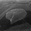
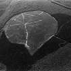
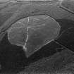
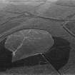
(Location cited as NJ 6490 2450; classified as Fort and Site of Regional Significance). Hill fort; the largest enclosed site (c. 200 by 170m) in NE Scotland. Now surrounded by a forestry plantation.
The low rounded summit (at altitude 250m OD) is enveloped by a stone bank (spread to approx. 4m width and 0.5m height) fringed on inner edge by quarry-scoops. It is difficult to trace the entire circuit but a gap is apparent on the W and may be the original entrance. 8 huts (c. 7-8m in diameter) as well as platforms or quarry-scoops in the interior.
[CUCAP air photography listed].
NMRS, MS/712/35.
On the date of visit this settlement was choked with rank gorse, broom and heather. None of the internal features, which include several hut-circles, could be identified, nor was it possible to establish the exact character and dimensions of the enclosing bank or wall.
Visited by RCAHMS (JRS), 6 November 1996.
Field Visit (17 July 1943)
This monument is situated on the summit of Tillymuick, at an elevation of 834 feet above sea-level and of about 500 ft above the valley-bottom at Kirkton, half a mile away to the NW. The summit is so gently rounded that, in spite of the large size of the enclosure, its centre is but slightly higher than its perimeter. There is a modern cairn on the summit, and the compass-bearings given below have reference to this and not to the central point of the enclosure.
The enclosure proved too large for single-handed survey, but the 25” OS map shows that it is practically circular, measuring internally 550ft from N to S by 560ft E to W. The enclosing wall, or at least its foundations, are of stone, but it is now reduced for the most part to a low heather-covered mound up to 12ft in breadth. Only at one point, on the NE, does it stand as much as 2ft high externally; again only at one point can the true thickness be measured between exposures of the inner and outer faces – this on the SW, the thickness there being 9ft. There is no ditch, and the stones must therefore presumably have been gathered on the surface; their size suggests a very solid type of masonry. There are three gaps in the wall, all of which may have been entrance4s, but none of which can be positively identified as such; one on the W and another on the SE are 5ft to 6ft in breadth, while the third, which occurs on the SW at a shallow swampy hollow, is 12ft broad. On the NNW a fairly modern track breaks through the line of the wall; this is no doubt connected with the working of some small quarries and the collection of loose stones from the surface – indeed, the poor preservation of the wall is probably e to be attributed in large measure to stone-robbers. Further evidence of these activities is to be seen in the virtual disappearance of the wall in part of the N sector; in the small piles of stone, evidently quite modern, that have been prepared for removal; in the hollows from which large stones have been extracted; and in the clearance of superficial; stones, otherwise very plentiful, from parts of the enclosures area and of the hillside without.
The enclosure contains a number of hut-circles, perhaps up to two dozen, but no count was possible as the ground was much obscured by a heavy growth of heather. No doubt many more details would appear if the heather was burnt. The largest hut noted was on the extreme summit, just W of the modern cairn; this one is round, and measures 25ft in diameter. The best-preserved one is with others in a group, SW of the cairn; it measures 16ft in diameter, and shows stones as well as turf in its foundations. There is another group on the W, averaging about 15ft in diameter and partly dug back into the slope to bring their floors to a level. In addition to the hut-circles three small cairns, of the type usually believed to represent collections of field stones, were observed N of the cairn; whatever be the origin of these particular cairns, it is worth noting any attempts that may have been made in ancient times to clear this especially stony area were comparatively ineffective seeing that, in spite of further recent clearance that has been described above, a great part of the enclosure is still much too heavily encumbered for cultivation.
Visited by RCAHMS (AG) 17 July 1943.
(OS xliv SE ‘Earthwork and Tumuli’)
Field Visit (20 May 1957)
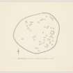
NJ 650 245. This settlement occupies the higher part of a broad ridge protruding N from the W part of the Bennachie massif, one and a half miles SW of Oyne. It is so placed that the local summit falls in the E sector, most of the enclosed area thus lying on the sloep facing W. of irregular oval plan, the settlement measures 680 feet from E to W by 545 feet transversely within a band about 10 feet in breadth of tumbled blocks and stones. No facing stones can be seen, and while it is very likely that the stone represents the ruin of a wall, it is also possible that they were never more than an obstacle, rendered more formidable, it may have been by the addition of a fence of quick hedge. Whatever the original form taken by this large and impressive collection of stones, however, the foundations of the interior present an equally unfamiliar appearance. At the date of visit most of the W third of the interior and of the wall of the settlement lay under luxurious heather through which only one foundation could be seen, but in the rest of the interior a further 55 were plotted. Many of these structures are not very easily visible on the uneven and stony ground consisting as they do merely of often fragmentary and always somewhat spare circles of large stones about 20 feet in diameter the interiors sometimes slightly dished. It is difficult, though not impossible, to believe that they ever formed the lower courses of drystone walls and another explanation for their appearance should be sought. While it is possible to plot 56 rings on the day of visit it is certain that a good many more must exist chiefly under heather in the W sector but also over the rest of the site. It is indeed possible that there were originally at least twice as many and Air photographs (106G/Scot/UK 139, 4027-8, 3 July 1946) suggest that almost all available ground was covered by them. One rectangular foundation of exactly the same appearance as the circular one lies near the centre of the settlement. The entrance is in the NE.
Visited by RCAHMS 20 May 1957.
Measured Survey (20 May 1957)
Plane-table survey. Plan redrawn in ink but unpublished.
Field Visit (6 November 1996)
NJ62SW 3 6495 2450
On the date of visit this settlement was choked with rank gorse, broom and heather. None of the internal features, which include several hut-circles, could be identified, nor was it possible to establish the exact character and dimensions of the enclosing bank or wall.
Visited by RCAHMS (JRS), 6 November 1996.
Field Visit (April 2015)
NJ 6498 2448 The status of this hilltop settlement has been questioned over recent years. In 1957 the OS [sic, RCAHMS] reported over 50 hut circles on the hill and the site was accordingly scheduled. More recent visits from RCAHMS and Historic Scotland have suggested that no more than eight are visible but also note that the interior is ‘choked with rank gorse, broom and heather’. The survey in April 2015 entailed the clearance of a limited area of undergrowth from an area shown on the 1957 survey to have contained various archaeological features. This was followed by a plane table survey recording all visible features in that area. The results, after taking account of the large drift of magnetic N since 1957, suggests that, within this limited area, the OS’s [sic] recorded features are still largely visible. Moreover, rather than simply the hut circles recorded by the OS [sic], it might be suggested that further linear features also survive. However, the surviving, above ground evidence for most of these features is very slight and further work would be required to confirm these findings.
Archive: Moray and Aberdeenshire Council SMR
Colin Shepherd – Bennachie Landscapes Fieldwork Group
(Source: DES, Volume 16)
Note (20 April 2015 - 31 August 2016)
This large enclosure is situated in a clearing on the gently rounded summit of a low hill enclosed within the forestry plantations along the N flank of the Bennachie hills. Where its perimeter can be traced through the rank heather and dense thickets of gorse and whins, it appears as a low stony bank spread 4.5m in thickness and no more than 0.5m in height, which has been constructed with material grubbed up from a shallow internal quarry about 5m in breadth to enclose an oval area measuring about 195m from ENE to WSW by 165m transversely (2.7). A gap in the bank on the N is approached by a hollowed trackway, but when most recently surveyed by RCAHMS, the investigators could detect little trace of the 56 hut-circles identified on a plan drawn up in 1957 during the RCAHMS Survey of Marginal Lands.
Information from An Atlas of Hillforts of Great Britain and Ireland – 31 August 2016. Atlas of Hillforts SC2963

