|
Prints and Drawings |
ABD 9/1 |
Records of the Royal Commission on the Ancient and Historical Monuments of Scotland (RCAHMS), Edinbu |
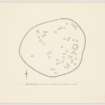
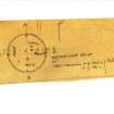
Inked plan: Tillymuick. |
c. 1957 |
Item Level |
|
|
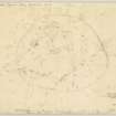
Prints and Drawings |
ABD 9/2 |
Records of the Royal Commission on the Ancient and Historical Monuments of Scotland (RCAHMS), Edinbu |
Plane-table survey: Tillymuick. |
20/5/1957 |
Item Level |
|
|
Photographs and Off-line Digital Images |
D 82966 PO |
Records of Aberdeen Aerial Surveys, Aberdeen, Scotland |
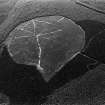
Tillymuick, settlement: aerial view under snow. |
25/11/1981 |
Item Level |
|
|
Photographs and Off-line Digital Images |
D 98611 PO |
Records of Aberdeen Aerial Surveys, Aberdeen, Scotland |
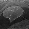
Tillymuick, settlement: oblique air photograph under snow. |
6/1/1982 |
Item Level |
|
|
Manuscripts |
MS 712/35 |
Records of Aberdeenshire Archaeology Service, Aberdeen, Scotland
|
Photocopies of updates to Aberdeenshire Archaeological Service (formerly Grampian Regional Council) SMR, relating to sites, finds and monuments within area of former Grampian Region, received September 1998. |
1998 |
Item Level |
|
|
Manuscripts |
MS 712/36 |
Records of Aberdeenshire Archaeology Service, Aberdeen, Scotland
|
Photocopies of updates to Aberdeenshire Archaeological Service (formerly Grampian Regional Council) SMR, relating to sites, finds and monuments within area of former Grampian Region, received April 1997 (with supplementary information and covering letter). |
1997 |
Item Level |
|
|
Photographs and Off-line Digital Images |
D 40917 |
RCAHMS Aerial Photography |
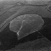
Oblique aerial view centred on the remains of the settlement taken from the NW. |
8/3/1999 |
Item Level |
|
|
Photographs and Off-line Digital Images |
D 40918 |
RCAHMS Aerial Photography |
Oblique aerial view centred on the remains of the settlement taken from the SSE. |
8/3/1999 |
Item Level |
|
|
Photographs and Off-line Digital Images |
D 40919 |
RCAHMS Aerial Photography |
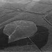
Oblique aerial view centred on the remains of the settlement taken from the SE. |
8/3/1999 |
Item Level |
|
|
Photographs and Off-line Digital Images |
D 40920 |
RCAHMS Aerial Photography |
Oblique aerial view centred on the remains of the settlement taken from the E. |
8/3/1999 |
Item Level |
|
|
Digital Files (Non-image) |
GV 000239 |
Records of the Royal Commission on the Ancient and Historical Monuments of Scotland (RCAHMS), Edinbu |
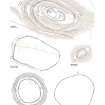
Comparative page of forts in Donside; Dunnideer; Bruce's Camp; Wheedlemont; Barmekin of Echt; Tillymuick. |
2007 |
Item Level |
|
|
Prints and Drawings |
DC 44612 |
Records of the Royal Commission on the Ancient and Historical Monuments of Scotland (RCAHMS), Edinbu |
Preparatory ink drawing for scanning of 1:1250 plans of enclosures at Hill of Keir (NJ80NW 1), White Hill (NJ52SW 1) and Tillymuick (NJ62SW 3). |
2003 |
Item Level |
|
 |
On-line Digital Images |
SC 1012681 |
Records of Aberdeen Aerial Surveys, Aberdeen, Scotland |
Oblique aerial view centred on the remains of the settlement at Tillymuick, looking to the SSE. |
23/8/1980 |
Item Level |
|
 |
On-line Digital Images |
SC 1012682 |
Records of Aberdeen Aerial Surveys, Aberdeen, Scotland |
Oblique aerial view centred on the remains of the settlement at Tillymuick, looking to the SSE. |
23/8/1980 |
Item Level |
|
 |
On-line Digital Images |
SC 1012683 |
Records of Aberdeen Aerial Surveys, Aberdeen, Scotland |
Oblique aerial view centred on the remains of the settlement at Tillymuick, looking to the SE. |
23/8/1980 |
Item Level |
|
 |
On-line Digital Images |
SC 1012687 |
Records of Aberdeen Aerial Surveys, Aberdeen, Scotland |
Oblique aerial view centred on the remains of the settlement at Tillymuick, looking to the SSE. |
23/8/1980 |
Item Level |
|
|
Manuscripts |
MS 124/3 |
Records of the Royal Commission on the Ancient and Historical Monuments of Scotland (RCAHMS), Edinbu |
Field notebook No. 2, A Graham (RCAHMS). |
8/8/1942 |
Item Level |
|
 |
On-line Digital Images |
DP 147348 |
Records of the Royal Commission on the Ancient and Historical Monuments of Scotland (RCAHMS), Edinbu |
Unpublished plan: Tillymuick. |
c. 1957 |
Item Level |
|
 |
On-line Digital Images |
DP 147349 |
Records of the Royal Commission on the Ancient and Historical Monuments of Scotland (RCAHMS), Edinbu |
Plane-table survey: Tillymuick. |
20/5/1957 |
Item Level |
|
 |
Digital Files (Non-image) |
WP 003401 |
Records of the Royal Commission on the Ancient and Historical Monuments of Scotland (RCAHMS), Edinbu |
RCAHMS Emergency Survey: Typescripts (Aberdeen). |
7/1943 |
Item Level |
|
 |
Digital Files (Non-image) |
WP 003405 |
Records of the Royal Commission on the Ancient and Historical Monuments of Scotland (RCAHMS), Edinbu |
Marginal Land Survey typescript site descriptions. |
1954 |
Item Level |
|
 |
On-line Digital Images |
SC 1456408 |
Records of the Royal Commission on the Ancient and Historical Monuments of Scotland (RCAHMS), Edinbu |
Sketch plan of the settlement at Tillymuick, filed with manuscript (MS 36). Scanned image from MS. |
17/7/1943 |
Item Level |
|
|
Manuscripts |
MS 36/274 |
Records of the Royal Commission on the Ancient and Historical Monuments of Scotland (RCAHMS), Edinbu |
RCAHMS Emergency Survey; manuscripts 1943 (vol.1) |
1943 |
Item Level |
|
 |
On-line Digital Images |
DP 234447 |
Records of the Royal Commission on the Ancient and Historical Monuments of Scotland (RCAHMS), Edinbu |
Comparative page of forts in Donside; Dunnideer; Bruce's Camp; Wheedlemont; Barmekin of Echt; Tillymuick. |
2007 |
Item Level |
|


