Pricing Change
New pricing for orders of material from this site will come into place shortly. Charges for supply of digital images, digitisation on demand, prints and licensing will be altered.
Field Visit
Date 20 May 1957
Event ID 931947
Category Recording
Type Field Visit
Permalink http://canmore.org.uk/event/931947
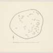
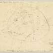
NJ 650 245. This settlement occupies the higher part of a broad ridge protruding N from the W part of the Bennachie massif, one and a half miles SW of Oyne. It is so placed that the local summit falls in the E sector, most of the enclosed area thus lying on the sloep facing W. of irregular oval plan, the settlement measures 680 feet from E to W by 545 feet transversely within a band about 10 feet in breadth of tumbled blocks and stones. No facing stones can be seen, and while it is very likely that the stone represents the ruin of a wall, it is also possible that they were never more than an obstacle, rendered more formidable, it may have been by the addition of a fence of quick hedge. Whatever the original form taken by this large and impressive collection of stones, however, the foundations of the interior present an equally unfamiliar appearance. At the date of visit most of the W third of the interior and of the wall of the settlement lay under luxurious heather through which only one foundation could be seen, but in the rest of the interior a further 55 were plotted. Many of these structures are not very easily visible on the uneven and stony ground consisting as they do merely of often fragmentary and always somewhat spare circles of large stones about 20 feet in diameter the interiors sometimes slightly dished. It is difficult, though not impossible, to believe that they ever formed the lower courses of drystone walls and another explanation for their appearance should be sought. While it is possible to plot 56 rings on the day of visit it is certain that a good many more must exist chiefly under heather in the W sector but also over the rest of the site. It is indeed possible that there were originally at least twice as many and Air photographs (106G/Scot/UK 139, 4027-8, 3 July 1946) suggest that almost all available ground was covered by them. One rectangular foundation of exactly the same appearance as the circular one lies near the centre of the settlement. The entrance is in the NE.
Visited by RCAHMS 20 May 1957.


