
Barmkyn Of North Keig


Cairn (Prehistoric), Fort (Prehistoric)
Site Name Barmkyn Of North Keig
Classification Cairn (Prehistoric), Fort (Prehistoric)
Alternative Name(s) The Barmkyn, Keig; Hill Of Airlie; Wood Of Northkeig
Canmore ID 17701
Site Number NJ52SE 8
NGR NJ 5991 2004
Datum OSGB36 - NGR
Permalink http://canmore.org.uk/site/17701


- Council Aberdeenshire
- Parish Keig
- Former Region Grampian
- Former District Gordon
- Former County Aberdeenshire
Classified as Site of Regional Significance. altitude 280m OD. Bivallate fort; the inner rampart is barely visible as an occasional stone protruding through heather but the outer rampart remains as a scatter of stones with an entrance 2m wide in the ESE. Internal diameter 33m E-W by 29m N-S. A low overgrown cairn of diameter 7.6m lies within; otherwise, no features visible. [Air photographic imagery listed].
NMRS, MS/712/35.
Scheduled as The Barmkyn, fort and cairn... a bivallate hillfort and a cairn of preghistoric date, visible as upstanding remains.
Informaton from Historic Scotlansd, scheduling document dated 18 October 2006.
Field Visit (19 August 1956)
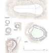
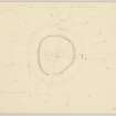
This structure stands at a height of 900ft OD 480 yards ESE of North Keig farmhouse on the broad flat summit of the high ground the E part of which is called the Hill of Airlie. It consists of an almost circular enclosure measuring 115 feet from E to W by 110 feet transversely within the ruins of two stone walls. The inner which runs round the rim of the slight mound that forms the summit of the hill consist of a scanty spread of large stones partly concealed under heather and gorse grass. The outer, distant some 20 feet from this on level ground and in a better state of preservation, consists of a mound of blocks of stones which measures about 13 feet in thickness, several inner and two outer facing stones being visible in situ among the ruins. The entrance is in the E. Within the interior, which is otherwise featureless, the slight remains of a cairn 25 ft in diameter lie in the S.
Visited by RCAHMS (RWF) 19 August 1956.
Desk Based Assessment (4 August 1967)
NJ52SE 8 5991 2004.
(NJ 5991 2004) The Barmkyn (NR)
Fort (NR) Cairn (NR).
OS 6" map, (1959)
This stone fort crowns the broad flat summit of an isolated hill which overlooks the Howe of Alford from the N. It consists of an almost circular enclosure measuring 115ft (35m) by 110ft (33.5m) within two ruined walls, the inner the more ruinous. The slight remains of a cairn 25ft (7.6m) in diameter are the only feature visible in the interior.
Information from OS (SW) 4 August 1967
Source:R W Feachem 1963.
Field Visit (15 September 1967)
The Barmkyn, a bi-vallate fort,situated on a flattish hill-top. The inner rampart is barely visible as an occasional stone protruding through the heather, enclosing an area about 33.0m in diameter E-W, and 29.0m in diameter N-S. The outer rampart remains as a scatter of stones, c.5.0m broad and c.0.5m high, with the entrance 2.0m wide in the ESE. The cairn within the fort as described by Feachem (1963) is very low and overgrown.
Re-surveyed at 1/2500.
Visited by OS (NKB) 15 September 1967.
Field Visit (21 November 2000)
This fort is situated on the summit of Hill of Airlie and, save for forest rides, it is completely enclosed within a conifer plantation that encroaches to the very edge of its defences. These comprise the remains a thick wall, now forming a mound of rubble some 8m in thickness by 1m in height with occasional inner and outer facing stones visible on the WNW and WSW respectively. The entrance is on the SE, opening into a roughly circular interior some 45m in diameter. This rises into a low summit, which is sharply defined by a stony scarp. The latter may be all that remains of a heavily robbed wall enclosing an area measuring about 31m from NW to SE by 25m transversely on the summit, and broken only by a gap some 4m wide on the SE.
The only other feature visible within the fort is a cairn measuring about 8m from ESE to WNW by 6.5m transversely and 0.2m in height; it is surmounted by a small marker cairn.
Visited by RCAHMS (JRS), 21 November 2000.
Excavation (24 April 2017 - 28 April 2017)
NJ 5991 2004 (NJ52SE 8) As part of the Northern Picts project surveys and excavations have been undertaken on a number of enclosed settlements in Moray and Aberdeenshire to help construct regional datasets on the dating of fortified settlement.
A five day evaluation was undertaken, 24–28 April 2017, at the bivallate fort lying on the summit of the Hill of Airlie. The monument consists of a very denuded inner rampart around 25–31m in diameter surrounded by a much more substantial stone wall c8m in diameter which encloses the central area of c45m diameter. An outer entrance c4m wide survives on the SE side of the outer wall.
Scheduled monument consent was obtained to open a 2 x 2m trench in the interior and a 3 x 1m trench across the exterior stone wall to obtain dating evidence for the site. The interior trench identified a possible low stone wall and associated floor layer or old ground surface. A possible pit was found associated with the possible floor layer. The outer enclosure wall was shown to be constructed straight on the bedrock in this area of the fort. The wall survives to c3m wide and up to 0.5m in height. A section through part of the wall showed facing stones and a rubble core. Radiocarbon dating on samples from the interior trench is under way.
Archive: University of Aberdeen
Funder: University of Aberdeen and Historic Environment Scotland
Gordon Noble and Oskar Sveinbjarnarson – University of Aberdeen
(Source: DES, Volume 18)
Note (3 April 2017)
This small fortification is situated on the summit of the Hill of Airlie, in a clearing in the plantation that has clothed its upper slopes since the early 19th century. Roughly circular on plan, the principal defence is a wall reduced to a mound of rubble between 5m and 8m in thickness by up to 1m in height, which encloses an area some 45m in diameter (0.16ha); a few inner and outer facing-stones are visible on the W quarter, though in insufficient numbers to measure the thickness, and the entrance is on the ESE. Within the interior the ground rises into a low summit, and the stony scarp that defines its margin is possibly the remains of a heavily robbed wall enclosing an area measuring 31m across (0.08ha); while the relationship between the two walls is unknown, the relatively poor state of preservation of the inner suggests that it may be the earlier. The only other feature visible within the interior is a cairn measuring about 8m from ESE to WSW by 6.5m transversely and 0.2m in height.
Information from An Atlas of Hillforts of Great Britain and Ireland – 03 April 2017. Atlas of Hillforts SC2955

