
Portmahomack, Tarbatness Road, Tarbat West Church, Churchyard


Burial Ground (Period Unassigned), Churchyard (Period Unassigned)
Site Name Portmahomack, Tarbatness Road, Tarbat West Church, Churchyard
Classification Burial Ground (Period Unassigned), Churchyard (Period Unassigned)
Alternative Name(s) Tarbat Old Parish Church, Burial-ground; Old Tarbat Burial-ground
Canmore ID 15664
Site Number NH98SW 4.02
NGR NH 91502 84033
NGR Description Centred NH 91502 84033
Datum OSGB36 - NGR
Permalink http://canmore.org.uk/site/15664


- Council Highland
- Parish Tarbat
- Former Region Highland
- Former District Ross And Cromarty
- Former County Ross And Cromarty
NH98SW 4.02 centred 91502 84033
Watching Brief (2 April 2008 - 21 November 2008)
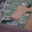
A watching brief was undertaken, 2 April–21 November 2008, on 12 areas of open cut trenching along a water renewal route. The areas were centred on the following NGRs – NH 9157 8460 (Harbour Road), NH 917 845 (Chapel Street), NH 84149 78523 (Hill of Fearn to Rhynie Road), NH 91716 84574 (Chapel Place), NH 84116 78542 (Rhynie Farmhouse Dyke), NH 91587 84252 (Gaza), NH 87800 79159 (Chapel Field Boundary Dyke), NH 88389 79178 (St Mary’s Chapel/Cathabul), NH 88926 79068 (Cadboll Mound), NH 9156 8455 (Harbour Street/Castle Street), NH 9164 8452 (Castle Street) and NH 91456 84031 (Tarbatness Road).
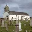
The route along the eastern side of Tarbatness Road passes close to the known site of a Pictish early medieval monastic settlement and burial ground (NH98SW 4.02) and of Tarbat old parish church (NH98SW 4.00), partially rebuilt in the 18th century. The main structure retains its medieval E–W orientation. Below the E end of the church is a vaulted crypt.
During trenching at NH 91442 84008, W of the gate to the churchyard, a fragment of carved sandstone was recovered from the ballast that had been laid under the modern road. It is believed to be a column capital, decorated in the Gothic style and may date to the 13/14th centuries. The front face shows relief-carved and incised Gothic scrollwork over two of the surviving four panels. Each scroll measured 0.17m in diameter and is squared off at the reverse extent of each of the side faces. A simple cruciform pictogram has been incised lightly onto one of the side panels of the columnar shaft. The reverse face has been pecked out, creating an ‘hourglass’-shaped void, indicating likely re-use. The fragment is 475mm long, 330mm wide and 180mm deep. Further specialist analysis is needed to determine the date and purpose of this carved stone fragment.
The Water Main Renewal Project will continue into the early part of 2009. A full report will be published once works have been completed.
Archive: Highland Archaeology Services Ltd
Funder: Halcrow Group Ltd for Scottish Water
Cait McCullagh – Highland Archaeology Services Ltd

