
Scheduled Maintenance
Please be advised that this website will undergo scheduled maintenance on the following dates: •
Tuesday 3rd December 11:00-15:00
During these times, some services may be temporarily unavailable. We apologise for any inconvenience this may cause.
The Mound


Causeway (19th Century), Railway (20th Century), Road Bridge (19th Century)
Site Name The Mound
Classification Causeway (19th Century), Railway (20th Century), Road Bridge (19th Century)
Alternative Name(s) Strathfleet; Golspie, Mound Bridge; Dornoch Light Railway; Fleet Causeway; Fleet Mound; River Carnaig
Canmore ID 14787
Site Number NH79NE 44
NGR NH 77549 98219
Datum OSGB36 - NGR
Permalink http://canmore.org.uk/site/14787


- Council Highland
- Parish Dornoch
- Former Region Highland
- Former District Sutherland
- Former County Sutherland
NH79NE 44 77549 98219 (NH 77563 98238 to NH 76872 97704)
For adjacent (The) Mound Station (NH 7752 9835), see NH79NE 45.
THE MOUND [NAT] (name centred NH 7718 9793)
OS 1:10,000 map, 1971.
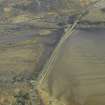
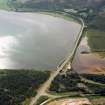
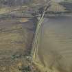
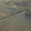
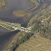
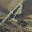
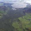
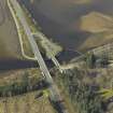
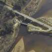
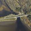
(Location cited as NH 769 978 to 774 982). The Mound, built 1814-16 by engineer Thomas Telford. An embankment with a bridge at the northern end, spanning the mouth of Loch Fleet. The bridge was originally of 4-arch form but had two further arches added by Joseph Mitchell in 1837. The arches are fitted with non-return flap valves to prevent sea water penetrating to Loch Fleet.
J R Hume 1977.
This earthern mound or dyke was built by Telford to prevent seawater flooding of the low-lying land watered by the rivers Carnaig and Fleet. Its construction severely tested the builders and was superintended by John Mitchell, Telford's resident deputy in the Highlands.
The bridge is the most northerly section of the mound, and is overshadowed by the new A9 bridge. It is both beautiful and unusual in form, incorporating non-return valves in the form of wooden flaps. Small stone buildings on each side house winding-gear to raise some of the flaps so as to allow the passage of fish. The posts upstream of the bridge are intended to protect it against floating debris and ice-floes.
The Dornoch Light Railway crossed the bridge between 1900 and 1960.
G Nelson 1990.
This causeway formerly carried the Dornoch Light Railway and the A9 public road over the estuary of the River Fleet (and its tributary the Carnaig) near the inner end of Loch Fleet, between the parishes of Golspie and Dornoch.
Information from RCAHMS (RJCM), 6 May 1998.
This causeway carries the A9 (T) public road across the inner (NW) end of Loch Fleet, at the lower (SE) end of Strath Fleet. The River Fleet passes under the NE end, and here forms the boundary between the parishes of Golspie (to the NE) and Dornoch (to the SW).
The location assigned to this record defines the midpoint of the structure. The available map evidence indicates that it extends from NH c. 77563 98238 to NH c. 76872 97704.
Information from RCAHMS (RJCM), 10 May 2006.
Construction (1813 - 1816)
The Mound, designed and constructed under Telford’s general direction, and implemented by Earl Gower and others as contractors, was almost 1000 yards long, 60 yards wide at the base and 23 ft high. It was built from 1813–16 at a cost of £9290.
R Paxton and J Shipway, 2007.
Modification (1834)
Modified - additional 2 arches and winches installed to enable manual opening of flap-gates.
Publication Account (1995)
The Mound is a great earthen embankment faced with stone on the seaward side, and with a bridge at its north end, that carries the parliamentary road across the upper end of Loch Fleet. It acts as a tide barrier, stopping the sea some 2.5km short of its natural tidal limits. The bridge has four arches planned by Thomas Telford, and two others added by Joseph Mitchell in 1837, all fitted with wooden non-return Bap valves that allow the river to run out bur prevent sea-water returning upriver. At certain times the Baps are opened mechanically to allow salmon to swim upriver. Above this barrier what was a salty, tidal river is now fresh water, and many acres formerly Booded at high tide have been reclaimed.
The Mound was part of the works carried out on the parliamentary road from Inverness to Wick and Thurso. Telford had intended to build new ferry piers for the Little Ferry, at the mouth of Loch Fleet. It was William Young, then factor to the Sutherland estates, who suggested a causeway across the head of the estuary, which Telford designed and which was built with local labour. It was constructed between 1814 and 1816, and took longer and cost more than expected, as with many similar projects. Young wrote on 3rd June 1816 as the last breach was about to be filled 'We are all prepared to battle the sea with 600 men. Walklate is brewing 30 hogsheads of ale and the Baker is getting 40 Boils of Meal converted into Bread, for the people must be fed'. After many difficulties, the work was completed, and the Countess of Surterland crossed the Mound on 26th June 1816 'carriage and all '.
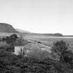
In 1900 Telford's embankment was utilized for the Dornoch Light Railway, a branch line from the Mound Station to Dornoch, which was closed in 1960. Two piers of the railway bridge stand in the iver upstream from the road bridge. The Mound Station (NH 775983), built in 1877 for the Sutherland Railway, survives as a private house by the railway embankment near the bridge. The wooden piles in the water are to prevent ice damaging the bridge.
There are information boards in the carpark at the north end of the Mound. The road here was realigned during major roadworks in 1990. The Fleet estuary is a nature reserve and many birds can be seen.
Information from ‘Exploring Scotland’s Heritage: The Highlands’, (1995).
Modification (2004)
Modernised - original 1834 winches removed and donated to Dornoch Museum and Heriot Watt University Civil Engineers Museum respectively.
Publication Account (2007)
Fleet Mound
(Institute Civil Engineers Historic Engineering Works no. HEW 0132)
In 1813 Telford, who for ten years had been directing a major improvement of the road network in the Highlands, was looking for the means of superseding the inconvenient Little Ferry of the Water of Fleet on the great road from Edinburgh to Thurso. He developed a scheme first projected by local landowner Earl Gower, from 1803 the Marquis of Stafford, for an embankment across the estuary about 3 miles upstream.
The Mound, designed and constructed under Telford’s general direction, and implemented by Earl Gower and others as contractors, was almost 1000 yards long, 60 yards wide at the base and 23 ft high. It was built from 1813–16 at a cost of £9290, and was a precursor of Telford’s 1300 yards Stanley Embankment of 1823–24 on the London to Holyhead Road.
A unique feature of this project, supported financially by the Marquis of Stafford, was the incorporation of a land reclamation facility at its north end where the Fleet was crossed by the new road bridge, 15 ft wide within parapets, of four arches of 12 ft span, increased to six in 1834. Two timber tidal flap-gates were fitted at the sea face of each arch below the springings which, by preventing sea water from passing upstream at high tide and allowing the river to flow out to sea at low tide, enabled about 400 acres of land to be reclaimed.
At times when the river was in flood, the flap-gates were unable to pass sufficient water out to sea at low tide and a mechanism involving brackets, pulleys, chains and hand operated winches was devised and installed to lift the flap-gates manually when necessary. Since 1834 the system has been operated by two winches each located within a purpose-built house at each end of the bridge and operating three flap-gates.
In 2004 the system was modernised. One winch was donated to Dornoch Museum and the other to the Institution of Civil Engineers Museum at Heriot-Watt University where, respectively, they are displayed and interpreted.
R Paxton and J Shipway, 2007.
Reproduced from 'Civil Engineering heritage: Scotland - Highlands and Islands' with kind permission from Thomas Telford Publishers.
Publication Account (17 March 2020)
The application of a large English fortune on a huge Scottish Estate.
In 1785 George Granville Leveson-Gower, with the courtesy title of Viscount Trentham, had married Elizabeth Sutherland, Countess of Sutherland in her own right. In 1803, on the detah of his father, he became the 2nd Marquis of Stafford. and inherited the Levenson fortune. Earlier in the saqme year he had inherited from his maternal uncle, the 3rd Duke of Bridgewater, the Bridgewater fortune. The marquis was created a Duke in 1833 and took the title of the Duke of Sutherland. It is he who is commemorated in the enormous statue on Ben Bhraggie above Golspie.
The acquisition of these fortunes appears to have initiated the construction of a lot of infrastructure on his wife's estates in Sutherland:
1805 The Sutherland Road Act
1808 Bridge over the Big Burn at Golspie
1810-14 Faskally coal mine, Brora
1810 Culmailly Canal - probbaly Marquis's influence rather than money
1810-11 Helmsdale Bridge
1812 Bonar Bridge
1813-16 Fleet Mound
Undated Other wayside hospices for travellers of which the Trentham Hotel, in the parish of Dornoch, is the most prominent.
In 1812 and 1816 the construction of the Bonar bridge and the Fleet Mound with the building of the Lovat bridge, Beauly (1811-14), Conon Bridgema d at Alness and Easter Fearn in 1817 provided a land route around the inlets of about 72 miles from Inverness to Golspie (day journey by horse) though the ferries remained in use by 'motor traffic' until the building of three bridges in the 20th century.
R Sutherland (ICEPHEW newsletter 162, undated)

