
Clava, Nairn Viaduct


Railway Viaduct (19th Century)
Site Name Clava, Nairn Viaduct
Classification Railway Viaduct (19th Century)
Alternative Name(s) Culloden Viaduct; Culloden Moor Viaduct; River Nairn
Canmore ID 14272
Site Number NH74SE 23
NGR NH 76413 44972
Datum OSGB36 - NGR
Permalink http://canmore.org.uk/site/14272


- Council Highland
- Parish Croy And Dalcross (Inverness)
- Former Region Highland
- Former District Inverness
- Former County Inverness-shire
NH74SE 23 76413 44972
Nairn Viaduct [NAT]
OS 1:10,000 map, 1990.
Location formerly cited as NH 7646 4462 to NH 7637 4512.
For (adjacent) Culloden Moor Station, see NH74NE 41.00.
Opened to traffic 1.11.1898.
(Undated) information in NMRS.
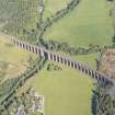
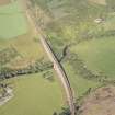
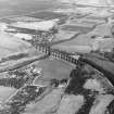
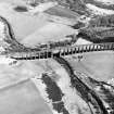
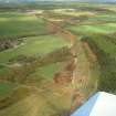
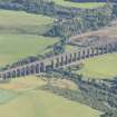
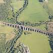
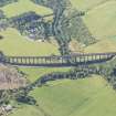
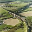
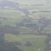
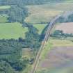
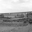
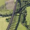
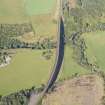
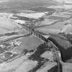
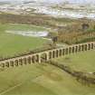
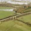
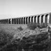
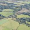
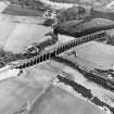
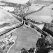
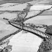
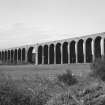
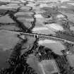
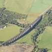
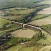
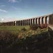
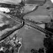
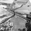
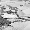
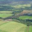
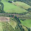
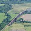
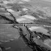
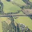
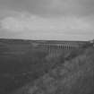
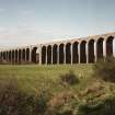
(Location cited as NH 763 450). Culloden Moor Viaduct, opened 1898 by the Highland Rly, engineer Murdoch Paterson. A remarkable 28-span masonry viaduct, the longest such in Scotland, 1800ft (549m). It is built on a curve.
J R Hume 1977.
This double-track viaduct is the longest masonry railway viaduct in Scotland. It was designed by Murdoch Paterson for the Highland Rly across the River Findhorn; it opened on 1 November 1898 and remains in use.
M Smith 1994.
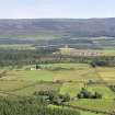
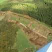
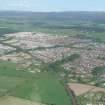
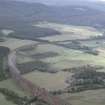
This viaduct carries the (current and diversion) Perth-Inverness main line across the River Nairn, which here forms the boundary between the portions of Croy and Dalcross parish in Inverness District (Inverness-shire) and Nairn District (Nairn), to the N and S respectively. It is approached by massive embankments on both N and S and forms a short break in the otherwise-unrelenting climb of the railway heading S from Inverness. It remains in regular use by passenger traffic.
The location assigned to this record defines the crossing-point of the structure over the River Nairn, somewhat to the N of its midpoint. The available map evidence (AIB GIS) indicates that it extends from NH c. 76361 45161 to NH c. 76472 44669.
Information from RCAHMS (RJCM), 23 March 2006.
Construction (1898)
Completed in 1898.
R Paxton and J Shipway, 2007.
Publication Account (2007)
Culloden Moor or Clava Viaduct
(Institute Civil Engineers Historic Engineering Works no. HEW 0601/03)
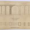
This gracefully curved viaduct with 29 semicircular arches over the valley of the Nairn, east of Culloden battlefield, 1785 ft long and 132 ft high at the river, is constructed of red sandstone and carries a single line of the former Highland Railway. It is asymmetrical with a river arch of 100 ft span,ten arches of 50 ft span at the north side and a further 18 of 50 ft span at the south side and is sometimes dubbed ‘the Forth bridge in stone’.
The piers, apart from at the river span, taper from 5 ft thick at the base to 612 ft at the spring line of the semicircular arches. Unusually there are no massive intermediate piers to prevent progressive collapse. The viaduct, the longest in Scotland, was completed in 1898 to a design by Murdoch Paterson. The contractors were Charles Brand & Sons, Glasgow.
R Paxton and J Shipway, 2007.
Reproduced from 'Civil Engineering heritage: Scotland - Highlands and Islands' with kind permission from Thomas Telford Publishers.

