Accessibility

Font Size

100% 150% 200%

Background Colour

Default Contrast
Close Reset

Pricing Change

New pricing for orders of material from this site will come into place shortly. Charges for supply of digital images, digitisation on demand, prints and licensing will be altered. 
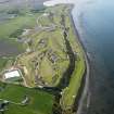
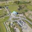
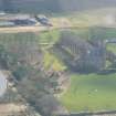
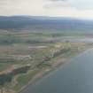
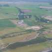
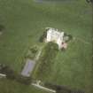
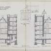
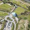
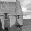
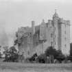
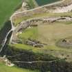
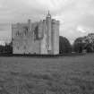
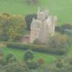
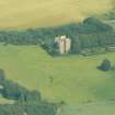
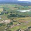
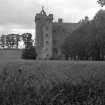
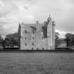
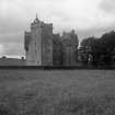
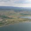
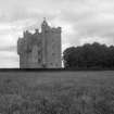
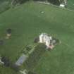
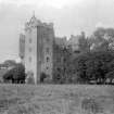
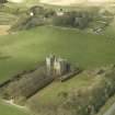
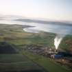
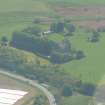
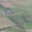
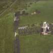
 

Castle Stuart

Castle (Medieval)

Site Name Castle Stuart

Classification Castle (Medieval)

Alternative Name(s) Castle Stewart; Hallhill

Canmore ID 14209

Site Number NH74NW 21
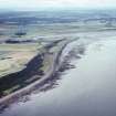
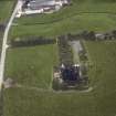
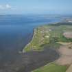
NGR NH 74159 49797

Datum OSGB36 - NGR

Permalink http://canmore.org.uk/site/14209

Ordnance Survey licence number AC0000807262. All rights reserved.
Canmore Disclaimer. © Bluesky International Limited 2025. Public Sector Viewing Terms

Toggle Aerial | View on large map

Digital Images

General oblique aerial view of Castle Stuart Golf Course, taken from the NE.
General oblique aerial view of Castle Stuart Golf Course, taken from the NE.Oblique aerial view of Castle Stuart Golf Course, taken from the ESE.Ground & 1st fl. plans (as existing)
Delt. Geo.Gordon & Co. Archts. Inverness 1948Castle Stuart, Petty parish, Inverness, HighlandAerial view of Castle Stuart, E of Inverness, looking S.Oblique aerial view of Castle Stewart Golf Course, E of Inverness, looking S.Aerial view of Castle Stuart Golf Course, E of Inverness, looking S.Turret and dormer on south east wingAerial viewGeneral oblique aerial view centred on the castle, taken from the SSW.Oblique aerial view of Castle Stuart Golf Course, taken from the SSW.2nd & 3rd fl.plans (as existing)
Delt. Geo.Gordon & Co. Archts. Inverness 1948Roof plan and sections (as existing)
Delt. Geo.Gordon & Co. Archts. Inverness 1948An oblique aerial view of Old Petty, Petty, Inverness, looking SW.Castle Stuart, NH74NW 21, Ordnance Survey index card, RectoAerial viewGeneral oblique aerial view of Castle Stuart Golf Course looking along the Moray Firth, taken from the SSW.Oblique aerial view of Castle Stuart Golf Course, taken from the ENE.Grd. & 1st fl.plans (as proposed)
Delt. Geo.Gordon & Co. Archts. Inverness 1948Castle Stuart, NH74NW 21, Ordnance Survey index card, RectoTurret and dormer on south east wingGeneral view
Oblique aerial view of Castle Stuart Golf Course, taken from the WNW.Oblique aerial view of Castle Stuart Golf Course, taken from the WNW.2nd & 3rd fl.plans (as proposed)
Delt. Geo.Gordon & Co. Archts. Inverness 1948Aerial view of Castle Stuart, near Inverness with its golf course under construction, looking SSW.View from north westOblique aerial viewView of roofsAerial view of Castle Stuart Golf Course under construction, E of Inverness, looking SW.Aerial view of Castle Stuart, near Dalcross, E of Inverness, looking E.Aerial view of Castle Stuart golf course and Old Petty Church, E of Inverness, looking S.General view from southView from northView from south westGeneral oblique aerial view of Castle Stuart golf course, looking NNE.An oblique aerial view of Alturlie Point, Petty, Inverness, looking SW.Oblique aerial view of Castle Stewart Golf Course, Petty, E of Inverness, looking S.Castle Stuart, NH74NW 21, Ordnance Survey index card, RectoView from westAerial viewGeneral view
Fleming CollectionTurret and dormer on south east wing4th,5th & roof plans (as existing)
Delt. Geo.Gordon & Co. Archts. Inverness 1948Oblique aerial view of Castle Stewart Golf Course, E of Inverness, looking S.Distant view from north eastOblique aerial view centred on the castle with the church, manse, walled garden and remains of the motte adjacent, taken from the E.Oblique aerial view of Castle Stuart Golf Course, taken from the WSW.Oblique aerial view of Castle Stuart Golf Course, taken from the SSE.An oblique aerial view of Moray Hill, Petty, Moray Firth, looking W.Oblique aerial view of Castle Stuart near Inverness, looking SSW.Oblique aerial view of Castle Stewart, Petty, E of Inverness, looking S.Castle Stuart, NH74NW 21, Ordnance Survey index card, page number 2, VersoAerial view

Administrative Areas

  • Council Highland
  • Parish Petty
  • Former Region Highland
  • Former District Inverness
  • Former County Inverness-shire

Archaeology Notes

NH74NW 21 74159 49797.

(NH 7414 4980) Castle Stuart On Site of (NAT) Hallhill Castle (NR)

OS 6"map, Inverness-shire, 2nd ed., (1906)

"Castle Stuart on Site of Hallhill Castle. As Castle Stewart (sic) is now inhabited this mode of writing the name has been adopted in order to retain the name of the ancient castle that once stood here..."

Name Book 1870.

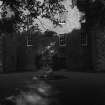
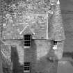
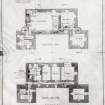
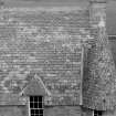
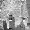
"Castle Stewart,...This large castle or mansion was built by the Earl of Moray about 1625"...The open work crowning the turret of the south-west staircase is modern, as are also the battlements of the south-west tower".

D MacGibbon and T Ross 1887-92.

To resolve the modern spelling of the name a predecessor of the present Earl of Moray was created a British Peer with the title Baron Stuart of Castle Stuart in 1796. (Debrett 1964).

Information from J Howie to OS 26 October 1964.

Castle Stuart is as described by MacGibbon and Ross. Date stones bearing the date 1625 are in the rear and front walls of the castle at roof height. The building is in good order and inhabited. There is no evidence of an older structure.

Visited by OS (E G C) 26 April 1962.

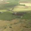
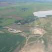
An air photograph, taken by Jill Harden in 1989, is in Inverness Museum (8905.01 INVMG).

Information from J Harden 1989.

Two medieval copper-alloy objects - a strap-end and a sword belt fastener - found by metal detecting.

P Weeks and H Gordon 2001

Architecture Notes

NMRS Print Room

Castle Stewart

2 exterior views

W Schomberg Scott Photograph Collection

Acc No 1997/39

NMRS REFERENCE

Owner: The Earl of Moray

Tenent: Mr Colin MacKenzie

Architect: partial restoration 1869

NMRS library

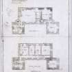
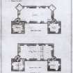
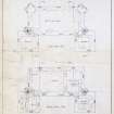
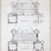
Castle Stuart - Inventory of Plans - typescript (R6 (P15))

EXTERNAL REFERENCE

National Library of Scotland

Country Life 23/1/1915 - article and photographs

Nattes drawings Vol 1 - nos 1 and 2 - 2 drawings

References

MyCanmore Image Contributions


Contribute an Image

MyCanmore Text Contributions