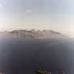
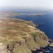
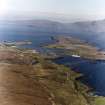
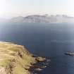
Accessibility

Font Size

100% 150% 200%

Background Colour

Default Contrast
Close Reset

Rum, General

General View (Period Unassigned)

Site Name Rum, General

Classification General View (Period Unassigned)

Alternative Name(s) Rhum

Canmore ID 138158

Site Number NM39NE 31

NGR NM 3664 9936

NGR Description Centred NM 3664 9936

Datum OSGB36 - NGR

Permalink http://canmore.org.uk/site/138158

Ordnance Survey licence number AC0000807262. All rights reserved.
Canmore Disclaimer. © Bluesky International Limited 2025. Public Sector Viewing Terms

Toggle Aerial | View on large map

Digital Images

General oblique aerial view of Sanday and S part of Canna, looking ESE towards Rum (Rhum).
General oblique aerial view of Sanday and S part of Canna, looking ESE towards Rum (Rhum).General oblique aerial view of Kilmory Glen, Rum, looking S.General oblique aerial view of the Islands of Muck, Eigg, Rum and Skye, taken from the SSE.General oblique aerial view of Rum and Canna with Sleat in the foreground, looking W.Oblique aerial view with Eigg and Rum in the distance.View of Rum taken from Poll Duchaill, Eigg.General oblique aerial view of Rum (Rhum) looking ESE from SW corner of Canna (An Steidh).General oblique aerial view of Eigg, Muck and Rum, taken from the SE.View from NNW near Lochan DornabacGeneral oblique aerial view of Sanday and SE coast of Canna looking ESE towards Rum (Rhum), showing Sgor nam  Ban-Naomha, a possible early Christian settlement.General oblique aerial view of Rum (Rhum) looking ESE from SW corner of Canna (An Steidh).General oblique aerial view of the island of Rum, looking SSW.General oblique aerial view of the coast of Rum, looking SE.General oblique aerial view of Askival, Rum, looking SSE.General oblique aerial view of Rum, looking W.General oblique aerial view of Rum centred on Bloodstone Hill, looking NEGeneral shot of staff setting up GPS repeater at the head of Glen Guirdil, Rum, with Bloodstone Hill in the background.General oblique aerial view of the Cullin Hills with Rum and Canna beyond, looking SW.General oblique aerial view of the remains of the fort with Rum in the distance, taken from the ESE.General oblique aerial view of the remains of the fort with Rum in the distance, taken from the ESE.General oblique aerial view of the island of Rum, looking WSW.General oblique aerial view of Rum, looking ESE.General oblique aerial view of Rum, looking NNE.General oblique aerial view of Askival, Rum, looking WSW.General oblique aerial view of Eigg and Rum, looking NW.General oblique aerial view of the Cullin Hills with Rum and Canna beyond, looking SW.Eigg, Howlin. General view of Howlin from SE with Rum in the background.Eigg, Five Pennies. View of Five Pennies twonship from SE with Rum in the background.General oblique aerial view of the remains of the fort with Rum in the distance, taken from the ESE.View near Lochan DornabacGeneral oblique aerial view of Sanday and SE coast of Canna looking ESE towards Rum (Rhum).General oblique aerial view of Loch Scresort, Rum, looking W.General oblique aerial view of Kilmory Glen, Rum, looking S.General oblique aerial view of Askival, Rum, looking WSW.General oblique aerial view of Askival, Rum, looking SE.General oblique aerial view of Trollabhal, Rum, looking N.General oblique aerial view of Rum, looking S.General view.General view of the Rum Cuilin.General view of the Rum Cuillin from Harris.General oblique aerial view of Eigg and Rum, looking NW.General oblique aerial view of Blabheinn with the Cullin Hills, Loch Scavaig, Soay, Eigg, Rum and Canna beyond, looking SSW.View from N near Lochan DornabacGeneral oblique aerial view of the interior of Rum with Skye beyond, looking NE.General oblique aerial view of Rum, looking NNE.Eigg, Five Pennies. View of field boundaries with Rum in the background.Oblique aerial view centred on the remains of the An Sgurr fort with Rum in the background, taken from the SE.General oblique aerial view of Eigg, Muck and Rum, taken from the SE.General oblique aerial view with Sorobaidh Bay in the foreground, Hynish Bay beyond and Rum and Eigg in the far distance, looking to the NE.General oblique aerial view of Kilmory Glen, Rum, looking SSE.General oblique aerial view of the coast of Rum at Sgorr Mor, looking NE.General oblique aerial view of the Point of Ardnamurchan looking out towards the Islands of Rum, Eigg, Muck and Skye, taken from the S.General oblique aerial view of Ainshval and Sgurr nan Gillean, Rum, taken from the SW.Staff setting up a GPS repeater at the head of Glen Guirdil.View of Rum taken from Poll Duchaill, Eigg.View from W near Lochan DornabacGeneral oblique aerial view of Eigg, Muck and Rum, taken from the SE.Oblique aerial view centred on the remains of the An Sgurr fort with Rum in the background, taken from the SE.General oblique aerial view of Loch Scresort and Kinloch Castle, Rum, looking S.General oblique aerial view of Ainshval and Sgurr nan Gillean, Rum, taken from the SW.General oblique aerial view of Eigg, Rum and Canna with Gleann Meadhonach, Sleat, in the foreground, looking WSW.General oblique aerial view of Blabheinn with the Cullin Hills, Loch Scavaig, Soay, Rum and Canna beyond, looking SSW.General oblique aerial view of SW corner of Canna (Bre Sgorr and An Steidh), looking ESE towards Rum (Rhum).General oblique aerial view of Sanday and S part of Canna, looking ESE towards Rum (Rhum).General oblique aerial view of Sanday and SE coast of Canna looking ESE towards Rum (Rhum).View from S in Kilmory Glen.General oblique aerial view of Ainshval and Sgurr nan Gillean, Rum, taken from the SW.General view from Rum towards Canna.General oblique aerial view of Muck, Eigg and Rum, looking WNW.General oblique aerial view of Eigg, Rum and Canna with Gleann Meadhonach, Sleat, in the foreground, looking WSW.General oblique aerial view of SW corner of Canna (Bre Sgorr and An Steidh), looking ESE towards Rum (Rhum).View from NW to An DormabacView from NNE at Harris

Administrative Areas

  • Council Highland
  • Parish Small Isles
  • Former Region Highland
  • Former District Lochaber
  • Former County Inverness-shire

Archaeology Notes

NM39NE 31 centred 3664 9936

See under individual sites, finds, monuments and buildings.

Activities

Aerial Photography (2 September 1994)

References

MyCanmore Image Contributions


Contribute an Image

MyCanmore Text Contributions