
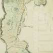
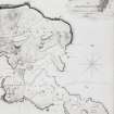
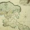
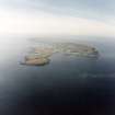
Canna


General View (Period Unassigned)
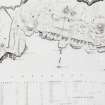
Site Name Canna
Classification General View (Period Unassigned)
Canmore ID 137927
Site Number NG20SW 46
NGR NG 2172 0481
Datum OSGB36 - NGR
Permalink http://canmore.org.uk/site/137927


- Council Highland
- Parish Small Isles
- Former Region Highland
- Former District Lochaber
- Former County Inverness-shire
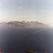
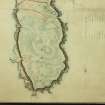
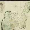
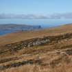
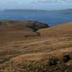
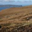
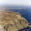
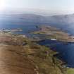
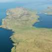
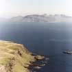
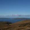
CANNA Canna lies on the Minch like a bird with outstretched wings, embracing with its offspring isle of Sanday a sheltered anchorage at its eastern end. It is around this natural harbour that the principal settlement is focused, the meadows of the home farm rising up to wind-sculpted plantations and flights of grassy terraces. Westwards, the landscape changes to rough moorland pasture and cleanly sliced basalt cliffs. Traces of Neolithic settlement, Bronze and Iron Age artefacts and possible Viking burial mounds, as well as of numerous later shieling huts and field systems, make Canna one of the best preserved prehistoric and historic landscapes in the Hebrides. It is plausible that this is the island referred to in Adamnan's Life of St. Columba as Hinba, where the saint is said to have founded a monastery; almost certainly Columba came to Canna during his trip to Scotland in 563-97. An important collection of Early Christian carved stones are the legacy of a religious settlement founded here around that time. In the medieval period this most fertile of Hebridean islands belonged to the Abbey of Iona, and its feudal superiors were thus the Bishops of the Isles. The Clanranalds were associated with Canna from the 14 th century, although only in 1805 did they obtain superiority from the Argyll family, who had succeeded the Bishops of the Isles as feudal superiors in 1628. The asset of a good sheltered harbour brought the island under the scrutiny of the British Fisheries Society in the 1780s, but negotiations with Clanranald and his tenant proved abortive, and Canna's potential for a planned fishing village remained unfulfilled. In 1787 the island was described as 'beautiful to the eye, abounding with good land, and exquisite pasture, very improveable'. Donald MacNeill, who bought Canna from Clanranald in 1827, built a mill (only substantial traces of its dam survive, although what is now the Catholic chapel was probably built in connection with it), and laid out a large walled kitchen garden 'well-stocked both with ornamental and fruit trees'. After his death in 1848, his son Donald severely reduced the population by instigating the clearances of 1851 and, in 1881, sold Canna to Robert Thom. This Glasgow shipowner improved and planted, upgraded crofters' cottages, built a pier and provided a steam-driven grain mill and smithy. In 1938, his descendants sold Canna to another improving landlord, the distinguished Gaelic scholar, writer and historian, Dr John Lorne Campbell (1906-96). He operated a productive farm, nurtured a precious sanctuary of mixed plantings and wildlife, and was noted as an entymologist with a rare collection of moths and butterflies. He also dedicated his life to recording and keeping alive the Gaelic culture and Hebridean way of life. In 1981, he gave Canna to the National Trust for Scotland in order that his unique library of Celtic and Norse studies, priceless collection of Gaelic manuscripts and tape recordings, and visual and other research material amassed over nearly a century by himself and his wife Margaret Fay Shaw, might be protected for the benefit of the public. The Trust is now in the process of realising this vision for a Centre of Advanced Studies on Canna.
Taken from "Western Seaboard: An Illustrated Architectural Guide", by Mary Miers, 2008. Published by the Rutland Press http://www.rias.org.uk


