|
Manuscripts |
MS 726/167 |
Records of CFA Archaeology Ltd, archaeologists, Musselburgh, East Lothian, Scotland |
Coastal Assessment Survey: Inner Moray Firth, Volumes 1 and 2. |
14/12/1998 |
Item Level |
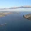
|
|
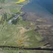
Photographs and Off-line Digital Images |
H 92919 CS |
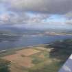
RCAHMS Aerial Photography |
General oblique aerial view of the Cromarty Firth, taken from the ENE. |
2/8/1991 |
Item Level |
|
|
Manuscripts |
MS 2776/1/11 |
Historic Scotland Archive Project |
Survey archive: Site record sheets, site record sheets with field notes and monument forms from the Inner Moray Firth (Moray, Beauly and Cromarty Firth) Coastal Assessment Survey. Sheet 11. |
9/1998 |
Item Level |
|
|
Prints and Drawings |
BD 104/1/11 |
Historic Scotland Archive Project |
Survey archive: 1:25,000 OS Pathfinder map depicting site locations from the Moray, Beauly and Cromarty Firth Coastal Assessment Survey. Sheet 11. |
9/1998 |
Item Level |
|
 |
On-line Digital Images |
DP 093605 |
RCAHMS Aerial Photography Digital |
Oblique aerial view of the pier, looking SE. |
24/7/2010 |
Item Level |
|
 |
On-line Digital Images |
DP 191671 |
RCAHMS Aerial Photography Digital |
Oblique aerial view of Dalmore Pier and the fishing stands, looking NNW. |
18/6/2014 |
Item Level |
|
 |
On-line Digital Images |
DP 211493 |
RCAHMS Aerial Photography Digital |
General oblique aerial view centred on the Dalmore Distillery and pier, looking NE. |
14/5/2015 |
Item Level |
|
 |
On-line Digital Images |
DP 211494 |
RCAHMS Aerial Photography Digital |
General oblique aerial view centred on the Dalmore Distillery and pier, looking NE. |
14/5/2015 |
Item Level |
|
 |
On-line Digital Images |
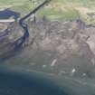
DP 211496 |
RCAHMS Aerial Photography Digital |
Oblique aerial view of fishing stands on the River Alness, Dalmore Distillery and pier, looking NNW. |
14/5/2015 |
Item Level |
|
 |
On-line Digital Images |
DP 211497 |
RCAHMS Aerial Photography Digital |
Oblique aerial view of fishing stands on the River Alness and Dalmore pier, looking NNW. |
14/5/2015 |
Item Level |
|
 |
On-line Digital Images |
DP 211498 |
RCAHMS Aerial Photography Digital |
Oblique aerial view of fishing stands on the River Alness and Dalmore pier, looking NNW. |
14/5/2015 |
Item Level |
|
 |
On-line Digital Images |
DP 211504 |
RCAHMS Aerial Photography Digital |
Oblique aerial view of Dalmore Distillery, looking SW. |
14/5/2015 |
Item Level |
|
 |
On-line Digital Images |
DP 211512 |
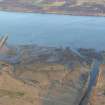
RCAHMS Aerial Photography Digital |
Oblique aerial view of Dalmore pier and mining sheds connected to US Naval Base 17 at Dalmore, looking SSW. |
14/5/2015 |
Item Level |
|
 |
On-line Digital Images |
DP 211517 |
RCAHMS Aerial Photography Digital |
General oblique aerial view of Dalmore Distillery and pier, looking NW. |
14/5/2015 |
Item Level |
|
|
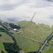
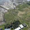
Photographs and Off-line Digital Images |
J 11962 CS |
Papers of Professor Geraint Dyfed Barri Jones, archaeologist, Manchester, England |
Oblique aerial view |
c. 1992 |
Item Level |
|
 |
On-line Digital Images |
SC 1590184 |
Papers of Professor Geraint Dyfed Barri Jones, archaeologist, Manchester, England |
Oblique aerial view |
c. 1992 |
Item Level |
|
 |
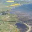
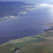
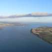
On-line Digital Images |
SC 1865113 |
Papers of James Sloan Bone, landscape historian, Inverness, Highland, Scotland |
Aerial view of Cromarty Firth, looking W. |
1994 |
Item Level |
|
 |
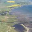
On-line Digital Images |
DP 341515 |
Papers of James Sloan Bone, landscape historian, Inverness, Highland, Scotland |
Oblique aerial view of Invergordon on the north side of the Cromarty Firth, looking W. |
8/8/2008 |
Item Level |
|
 |
On-line Digital Images |
DP 341643 |
Papers of James Sloan Bone, landscape historian, Inverness, Highland, Scotland |
Oblique aerial view of NE part of Cromarty Firth, looking NE. |
21/1/2009 |
Item Level |
|
 |
On-line Digital Images |
DP 341644 |
Papers of James Sloan Bone, landscape historian, Inverness, Highland, Scotland |
Oblique aerial view of NE part of Cromarty Firth, looking NE. |
21/1/2009 |
Item Level |
|
 |
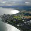
On-line Digital Images |
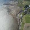
DP 341872 |
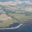
Papers of James Sloan Bone, landscape historian, Inverness, Highland, Scotland |
An oblique aerial view of Alness Point and Alness, Ross-shire, looking NE. |
15/11/2009 |
Item Level |
|
 |
On-line Digital Images |
DP 342255 |
Papers of James Sloan Bone, landscape historian, Inverness, Highland, Scotland |
Aerial view of Cromarty Firth, looking N. |
24/10/2010 |
Item Level |
|
 |
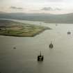
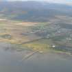
On-line Digital Images |
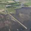
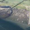
DP 342418 |
Papers of James Sloan Bone, landscape historian, Inverness, Highland, Scotland |
Aerial view of mouth of Alness River and Dalmore Pier, Cromarty Firth, looking SE. |
16/3/2011 |
Item Level |
|
 |
On-line Digital Images |
DP 343187 |
Papers of James Sloan Bone, landscape historian, Inverness, Highland, Scotland |
An oblique aerial view of Alness, Easter Ross, looking NE. |
1/10/2013 |
Item Level |
|


