
Scheduled Maintenance
Please be advised that this website will undergo scheduled maintenance on the following dates: •
Every Thursday from 17th October until 7th November from 11:00 to 15:00 •
Tuesday, 22nd October from 11:00 to 15:00
During these times, some services may be temporarily unavailable. We apologise for any inconvenience this may cause.
Romans in Scotland


17/08/2011
The might of the Roman Empire in the first four centuries AD reached as far north as Scotland. Their visits may have been fleeting but the Romans have left behind a lasting legacy of archaeological remains, including forts and temporary camps, signal towers and bath houses, and long linear works such as roads and the Antonine Wall, a World Heritage site. These sites form a prominent and important feature in Scotland’s past and have fascinated our people for nearly two thousand years.
The images in this collection represent a broad range of Roman sites, the people who excavated them and what they uncovered. The images detail over one hundred years of excavations but they also demonstrate how important aerial photography is, both for recording upstanding sites and for discovering the cropmarks of sites that have long since been ploughed flat.
Explore this collection and discover the rich legacy that the Romans left in Scotland.


SC 343848
Publication drawing: plan of Roman fort, Birrens, with elevation of storehouse C3.
© Crown Copyright: HES

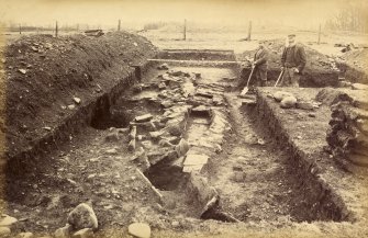
SC 349285
Excavation photograph of Mumrills Roman Fort, looking east into bath. Copied from A O Curle photograph album MS/28/461.
© RCAHMS

SC 349290
Excavation photograph of western hypocaust of Mumrills Roman Fort from SE. Copied from A O Curle photograph album MS/28/461. Duplicate of ST/1852.
© RCAHMS


SC 349291
Excavation photograph from Mumrills Roman Fort of outside of bath and S apse from E. Copied from A O Curle photograph album MS/28/461. Duplicate of ST/1857.
© RCAHMS

SC 349296
Excavation photograph from Mumrills Roman Fort showing the view to the W over the S half of large bath house. Copied from A O Curle photograph album MS/28/461. Duplicate of ST/1905.
© RCAHMS

SC 349297
Excavation photograph from Mumrills Roman Fort. Looking E to baths in praetentura. Copied from A O Curle photograph album MS/28/461. Duplicate of ST/1858.
© Courtesy of HES (Society of Antiquaries of Scotland Collection)

SC 349353
Plan of hypocaust CST (Calder) from Inveresk Roman Fort. Published version of RCAHMS MLD/40/1.
© RCAHMS


SC 349445
Oblique aerial view of Burnswark Roman Fort, seigeworks and other features.
© Crown Copyright: HES


SC 351353
Oblique aerial view of Castledykes Roman Fort, temporary camp and annexes.
© Crown Copyright: HES

SC 352668
Oblique aerial view of the headquarters building of Bar Hill Roman Fort during excavation
© RCAHMS


SC 355743
Excavation photograph from Fendoch Roman Fort showing oven number 5 from the east.
© Courtesy of HES. Papers of Sir Ian A Richmond, archaeologist, Oxford, England

SC 355746
Excavation photograph from Fendoch Roman Fort showing barrack 1 veranda, looking east.
© Courtesy of HES. Papers of Sir Ian A Richmond, archaeologist, Oxford, England


SC 355766
Publication drawing; plan of Roman fort and ring-ditch houses, Cargill
© Crown Copyright: HES


SC 373536
Oblique aerial view of Burnswark Roman Fort, siegeworks and other sites.
© Crown Copyright: HES


SC 528907
Oblique aerial view of Elginhaugh Roman Fort and annexe and 'Dere Street' Roman road during excavation in 1986.
© Crown Copyright: HES


SC 732703
Photograph of second Antonine ditch at Mumrills Roman Fort showing Sir George MacDonald in earlier deeper ditch coalescing with it. Copied from A O Curle photograph album MS/28/461.
© Courtesy of HES (Society of Antiquaries of Scotland Collection)


SC 872940
NW oblique aerial view of the excavations at Dullatur Roman Camps, Antonine Wall.
© Crown Copyright: HES


SC 902932
Oblique aerial view of Bar Hill Roman Fort interior and the Antonine Wall, taken from the W.
© Crown Copyright: HES

SC 905071
Oblique NNE aerial view of Ardoch Roman Fort, chapel, burial ground and adjacent road bridge.
© Crown Copyright: HES


SC 923290
Photograph from 1905-9 excavation of Newstead Roman Fort, showing bottom of titulus, W gate.
© Courtesy of HES (Society of Antiquaries of Scotland Collection)

SC 923322
View of artefact from the excavation of Newstead Roman fort by James Curle in 1905.
© Courtesy of HES (Society of Antiquaries of Scotland Collection)

SC 924568
SSW oblique aerial view of Dalginross Roman Fort and temporary camp.
© Crown Copyright: HES


SC 935545
Plan of buildings within Rough Castle Roman fort from Mungo Buchanan excavation in 1902-3.
© RCAHMS


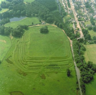
SC 941153
NNW oblique aerial view of Rough Castle Roman Fort and the Antonine wall.
© Crown Copyright: HES


SC 1020318
Oblique aerial view of Outerwards Roman fortlet, taken from the NW.
© Crown Copyright: HES

SC 1029099
Oblique aerial view of Ardoch Roman Fort, chapel, burial ground and adjacent road bridge, taken from the NNW.
© Crown Copyright: HES

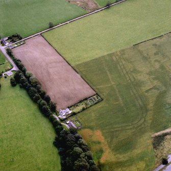
DP 011648
General oblique aerial view centred on the cropmarks of the Roman fort, Roman temporary camps and fort annexes with the railway viaduct adjacent, taken from the N.
© Crown Copyright: HES

DP 011978
Publication drawing of the eastern annexe and enclosures at Castledykes Roman Fort. Lanarkshire Inventory fig. 76.
© Crown Copyright: HES


DP 014299
ESE oblique aerial view of Rough Castle Roman Fort and the course of the Antonine Wall.
© Crown Copyright: HES

DP 019879
Oblique aerial view centred on the cropmarks of the Roman fort and fort annexe, taken from the SSE.
© Crown Copyright: HES


DP 020958
ESE oblique aerial view of the course of the Antonine Wall,Castlehill Roman Fort and possible fortlet.
© Crown Copyright: HES


DP 020962
NE oblique aerial view of Bearsden Roman Fort and the excavated bath-house.
© Crown Copyright: HES

DP 020973
SE oblique aerial view of Balmuildy Roman fort, the course of the Antonine Wall and adjacent Balmuildy road bridge.
© Crown Copyright: HES

SC 1064869
Oblique aerial view of Lurg Moor Roman fortlet, taken from the NNW.
© Crown Copyright: HES


SC 1079591
Excavation photograph from Mumrills Roman Fort of Antonine defence ditches 1,2 and 3. Copied from A O Curle photograph album MS/28/461.
© Courtesy of HES (Society of Antiquaries of Scotland Collection)

SC 1082712
Oblique aerial view of Rough Castle Roman Fort and the Antonine wall, taken from the WNW.
© Crown Copyright: HES


DP 048666
1793 plan of Dalginross Roman Fort and temporary camp. Inscribed: 'Plan of the Roman Camp at Dalgain-ross in Strathern supposed to be that wherin the 9th legion was attacked by the Caledonians in Agricola's 6th campaign shewing also the situation of Victoria founded by that General after his battle with Galgacus.'
© RCAHMS

SC 1138132
Oblique aerial view of Rough Castle Roman Fort and the Antonine wall, taken from the WSW.
© Crown Copyright: HES

SC 1138161
Photograph of Rough Castle Roman Fort excavation to illustrate a report by Mungo Buchanan in PSAS xxxix (1904-5)
© RCAHMS


SC 1138226
View of lilia pits at Rough Castle Roman Fort, NW of N Gate, taken from the East. Photograph illustrates a report by Mungo Buchanan, PSAS xxxix (1904-5)
© RCAHMS

SC 1138409
View of inner Antonine ditch with ledge on counter scarp at Mumrills Roman Fort during excavation 1923-1928.
© RCAHMS

SC 1138431
Excavation photograph from Mumrills Roman Fort of the crossing of the Antonine & E. to W. ditches.
© RCAHMS

SC 1138435
Excavation photograph from Rough Castle Roman Fort showing the foundation of the Antonine Wall with drain. Proceedings of the Society of Antiquaries of Scotland, May 8th 1905; Vol. XXXIX p. 442.
© RCAHMS


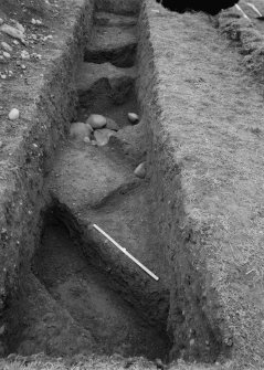
SC 1138438
Excavation photograph from Rough Castle Roman Fort showing the granary from the military way. Proceedings of the Society of Antiquaries of Scotland, May 8th 1905; Vol. XXXIX p. 442.
© RCAHMS

SC 1138439
Excavation photograph from Rough Castle Roman Fort showing inscribed tablet fragments from the headquarters building. Proceedings of the Society of Antiquaries of Scotland, May 8th 1905; Vol. XXXIX p. 442. SARI.TITO HADRIANO NINO.AVG P.P.COH.VI VIORVM.PRI PIA.FECIT In honour of (or in the reign of) the Emperor Ceasar Titus Aelius Hadrianus Antoninus Augustus Pius, Father of his Country, the sixth cohort of the Nervii made the headquarters.
© RCAHMS


DP 070817
Plan of Burnswark Roman Fort and seige earthworks from Alexander Gordon's 'Itinerarium septentrionale'.
© Courtesy of HES. llustration from Itinerarium septentrionale, Alexander Gordon, 1726


DP 074898
Photograph of south west rampart excavation trench at Ardoch Roman Fort, showing rough stone paving. Society of Antiquaries of Scotland excavations, 1896-7.
© Courtesy of HES (Society of Antiquaries of Scotland Collection)

DP 074899
Copy of original photograph showing masonry near the west gate of Ardoch Roman Fort. From the Society of Antiquaries of Scotland excavations in 1896-7.
© Courtesy of HES (Society of Antiquaries of Scotland Collection)

DP 075390
SW oblique aerial view of Rough Castle Roman Fort and the course of the Antonine Wall.
© Crown Copyright: HES


SC 1168033
Inscribed stone found at Birrens Roman Fort, now in the National Museum of Scotland.
© RCAHMS

SC 1168234
Pedestal of Roman altar found in Knockhill Summerhouse, thought to be from Birrens Roman Fort.
© Crown Copyright: HES

SC 1168902
Excavation photograph of Dalswinton and Bankhead Roman Forts.
© Courtesy of HES. Papers of Sir Ian A Richmond, archaeologist, Oxford, England


SC 1226553
View of Mumrills Roman Fort, thought to be a NW view of the praetorium, during the excavations 1923-1928.
© RCAHMS

SC 1243078
Principia at Glenlochar Roman Fort.
© Courtesy of HES. Papers of Sir Ian A Richmond, archaeologist, Oxford, England

SC 337283
Publication drawing; plan of Rough Castle Roman Fort, showing part of the Antonine Wall.
© Crown Copyright: HES
SC 343848
Publication drawing: plan of Roman fort, Birrens, with elevation of storehouse C3.
© Crown Copyright: HES
SC 349285
Excavation photograph of Mumrills Roman Fort, looking east into bath. Copied from A O Curle photograph album MS/28/461.
© RCAHMS
SC 349290
Excavation photograph of western hypocaust of Mumrills Roman Fort from SE. Copied from A O Curle photograph album MS/28/461. Duplicate of ST/1852.
© RCAHMS
SC 349291
Excavation photograph from Mumrills Roman Fort of outside of bath and S apse from E. Copied from A O Curle photograph album MS/28/461. Duplicate of ST/1857.
© RCAHMS
SC 349296
Excavation photograph from Mumrills Roman Fort showing the view to the W over the S half of large bath house. Copied from A O Curle photograph album MS/28/461. Duplicate of ST/1905.
© RCAHMS
SC 349297
Excavation photograph from Mumrills Roman Fort. Looking E to baths in praetentura. Copied from A O Curle photograph album MS/28/461. Duplicate of ST/1858.
© Courtesy of HES (Society of Antiquaries of Scotland Collection)
SC 349353
Plan of hypocaust CST (Calder) from Inveresk Roman Fort. Published version of RCAHMS MLD/40/1.
© RCAHMS
SC 349445
Oblique aerial view of Burnswark Roman Fort, seigeworks and other features.
© Crown Copyright: HES
SC 351353
Oblique aerial view of Castledykes Roman Fort, temporary camp and annexes.
© Crown Copyright: HES
SC 352668
Oblique aerial view of the headquarters building of Bar Hill Roman Fort during excavation
© RCAHMS
SC 355743
Excavation photograph from Fendoch Roman Fort showing oven number 5 from the east.
© Courtesy of HES. Papers of Sir Ian A Richmond, archaeologist, Oxford, England
SC 355746
Excavation photograph from Fendoch Roman Fort showing barrack 1 veranda, looking east.
© Courtesy of HES. Papers of Sir Ian A Richmond, archaeologist, Oxford, England
SC 355766
Publication drawing; plan of Roman fort and ring-ditch houses, Cargill
© Crown Copyright: HES
SC 373536
Oblique aerial view of Burnswark Roman Fort, siegeworks and other sites.
© Crown Copyright: HES
SC 528907
Oblique aerial view of Elginhaugh Roman Fort and annexe and 'Dere Street' Roman road during excavation in 1986.
© Crown Copyright: HES
SC 732703
Photograph of second Antonine ditch at Mumrills Roman Fort showing Sir George MacDonald in earlier deeper ditch coalescing with it. Copied from A O Curle photograph album MS/28/461.
© Courtesy of HES (Society of Antiquaries of Scotland Collection)
SC 872940
NW oblique aerial view of the excavations at Dullatur Roman Camps, Antonine Wall.
© Crown Copyright: HES
SC 902932
Oblique aerial view of Bar Hill Roman Fort interior and the Antonine Wall, taken from the W.
© Crown Copyright: HES
SC 905071
Oblique NNE aerial view of Ardoch Roman Fort, chapel, burial ground and adjacent road bridge.
© Crown Copyright: HES
SC 923290
Photograph from 1905-9 excavation of Newstead Roman Fort, showing bottom of titulus, W gate.
© Courtesy of HES (Society of Antiquaries of Scotland Collection)
SC 923322
View of artefact from the excavation of Newstead Roman fort by James Curle in 1905.
© Courtesy of HES (Society of Antiquaries of Scotland Collection)
SC 924568
SSW oblique aerial view of Dalginross Roman Fort and temporary camp.
© Crown Copyright: HES
SC 935545
Plan of buildings within Rough Castle Roman fort from Mungo Buchanan excavation in 1902-3.
© RCAHMS
SC 941153
NNW oblique aerial view of Rough Castle Roman Fort and the Antonine wall.
© Crown Copyright: HES
SC 1020318
Oblique aerial view of Outerwards Roman fortlet, taken from the NW.
© Crown Copyright: HES
SC 1029099
Oblique aerial view of Ardoch Roman Fort, chapel, burial ground and adjacent road bridge, taken from the NNW.
© Crown Copyright: HES
DP 011648
General oblique aerial view centred on the cropmarks of the Roman fort, Roman temporary camps and fort annexes with the railway viaduct adjacent, taken from the N.
© Crown Copyright: HES
DP 011978
Publication drawing of the eastern annexe and enclosures at Castledykes Roman Fort. Lanarkshire Inventory fig. 76.
© Crown Copyright: HES
DP 014299
ESE oblique aerial view of Rough Castle Roman Fort and the course of the Antonine Wall.
© Crown Copyright: HES
DP 019879
Oblique aerial view centred on the cropmarks of the Roman fort and fort annexe, taken from the SSE.
© Crown Copyright: HES
DP 020958
ESE oblique aerial view of the course of the Antonine Wall,Castlehill Roman Fort and possible fortlet.
© Crown Copyright: HES
DP 020962
NE oblique aerial view of Bearsden Roman Fort and the excavated bath-house.
© Crown Copyright: HES
DP 020973
SE oblique aerial view of Balmuildy Roman fort, the course of the Antonine Wall and adjacent Balmuildy road bridge.
© Crown Copyright: HES
SC 1064869
Oblique aerial view of Lurg Moor Roman fortlet, taken from the NNW.
© Crown Copyright: HES
SC 1079591
Excavation photograph from Mumrills Roman Fort of Antonine defence ditches 1,2 and 3. Copied from A O Curle photograph album MS/28/461.
© Courtesy of HES (Society of Antiquaries of Scotland Collection)
SC 1082712
Oblique aerial view of Rough Castle Roman Fort and the Antonine wall, taken from the WNW.
© Crown Copyright: HES
DP 048666
1793 plan of Dalginross Roman Fort and temporary camp. Inscribed: 'Plan of the Roman Camp at Dalgain-ross in Strathern supposed to be that wherin the 9th legion was attacked by the Caledonians in Agricola's 6th campaign shewing also the situation of Victoria founded by that General after his battle with Galgacus.'
© RCAHMS
SC 1138132
Oblique aerial view of Rough Castle Roman Fort and the Antonine wall, taken from the WSW.
© Crown Copyright: HES
SC 1138161
Photograph of Rough Castle Roman Fort excavation to illustrate a report by Mungo Buchanan in PSAS xxxix (1904-5)
© RCAHMS
SC 1138226
View of lilia pits at Rough Castle Roman Fort, NW of N Gate, taken from the East. Photograph illustrates a report by Mungo Buchanan, PSAS xxxix (1904-5)
© RCAHMS
SC 1138409
View of inner Antonine ditch with ledge on counter scarp at Mumrills Roman Fort during excavation 1923-1928.
© RCAHMS
SC 1138431
Excavation photograph from Mumrills Roman Fort of the crossing of the Antonine & E. to W. ditches.
© RCAHMS
SC 1138435
Excavation photograph from Rough Castle Roman Fort showing the foundation of the Antonine Wall with drain. Proceedings of the Society of Antiquaries of Scotland, May 8th 1905; Vol. XXXIX p. 442.
© RCAHMS
SC 1138438
Excavation photograph from Rough Castle Roman Fort showing the granary from the military way. Proceedings of the Society of Antiquaries of Scotland, May 8th 1905; Vol. XXXIX p. 442.
© RCAHMS
SC 1138439
Excavation photograph from Rough Castle Roman Fort showing inscribed tablet fragments from the headquarters building. Proceedings of the Society of Antiquaries of Scotland, May 8th 1905; Vol. XXXIX p. 442. SARI.TITO HADRIANO NINO.AVG P.P.COH.VI VIORVM.PRI PIA.FECIT In honour of (or in the reign of) the Emperor Ceasar Titus Aelius Hadrianus Antoninus Augustus Pius, Father of his Country, the sixth cohort of the Nervii made the headquarters.
© RCAHMS
DP 070817
Plan of Burnswark Roman Fort and seige earthworks from Alexander Gordon's 'Itinerarium septentrionale'.
© Courtesy of HES. llustration from Itinerarium septentrionale, Alexander Gordon, 1726
DP 074898
Photograph of south west rampart excavation trench at Ardoch Roman Fort, showing rough stone paving. Society of Antiquaries of Scotland excavations, 1896-7.
© Courtesy of HES (Society of Antiquaries of Scotland Collection)
DP 074899
Copy of original photograph showing masonry near the west gate of Ardoch Roman Fort. From the Society of Antiquaries of Scotland excavations in 1896-7.
© Courtesy of HES (Society of Antiquaries of Scotland Collection)
DP 075390
SW oblique aerial view of Rough Castle Roman Fort and the course of the Antonine Wall.
© Crown Copyright: HES
SC 1168033
Inscribed stone found at Birrens Roman Fort, now in the National Museum of Scotland.
© RCAHMS
SC 1168234
Pedestal of Roman altar found in Knockhill Summerhouse, thought to be from Birrens Roman Fort.
© Crown Copyright: HES
SC 1168902
Excavation photograph of Dalswinton and Bankhead Roman Forts.
© Courtesy of HES. Papers of Sir Ian A Richmond, archaeologist, Oxford, England
SC 1226553
View of Mumrills Roman Fort, thought to be a NW view of the praetorium, during the excavations 1923-1928.
© RCAHMS
SC 1243078
Principia at Glenlochar Roman Fort.
© Courtesy of HES. Papers of Sir Ian A Richmond, archaeologist, Oxford, England
