Accessibility

Font Size

100% 150% 200%

Background Colour

Default Contrast
Close Reset

RCAHMS Afforestable Land Survey, Menstrie Glen

Date 1997

Event ID 550872

Category Project

Type Project

Permalink http://canmore.org.uk/event/550872

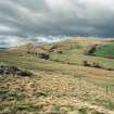
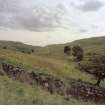
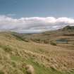
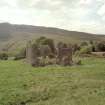
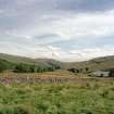
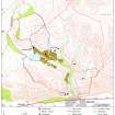
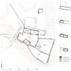
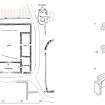
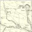
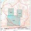
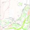
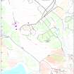
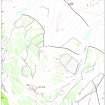
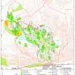
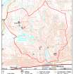
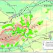
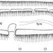
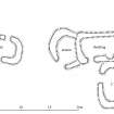
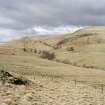
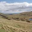
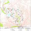
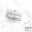
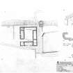
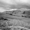
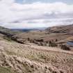
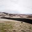
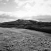
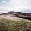
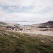
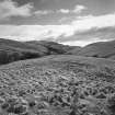
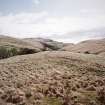
The field survey of the glen was undertaken by small teams of Royal Commission archaeological survey staff. Electronic Distance Measurement (EDM) equipment was used to plot each structure and bank against the detail of the modern OS map. Some areas of cultivation remains that were not closely defined by banks or other mapped features were also plotted on the ground; the remainder have been mapped from aerial photographs. The more ephemeral remains of cultivation are frequently difficult to see in the tussocky grass, and in many cases have been slighted by recent improvement. Fortunately, the RAF vertical photographs taken immediately after World War II, were flown under ideal conditions, with oblique sunlight striking many of the hillsides at low angles. This has served to bring many of the cultivated areas into high relief, providing an immediate indication of the character of the remains. In other areas the photographic cover has been supplemented with oblique views taken in the course of the Royal Commission's own aerial survey programme. The dimensions and characteristics of each structure within the survey area were recorded in the field into a database [MS 731/19, DX 001444] on a hand-held computer. This record was used to produce summary site descriptions for the NMRS, and, together with the survey data [TM 000560] and photographs, form a project archive that is available for public consultation.

Fieldwork for the archaeological survey was carried out by G L Brown, D C Cowley, P McKeague, R Shaw and J B Stevenson, with the assistance of S D Boyle, M M Brown, P J Dixon, A Forster, A J Leith and G P Stell. The drawings and other illustrative work have been undertaken by G L Brown and R Shaw. Photographic services have been provided by R M Adam, T Duncan and D Smart. The text has been written by D C Cowley and J G Harrison, with contributions from S P Halliday, and edited by S P Halliday and J B Stevenson. The layout of the volume has been prepared by J N Stevenson. The results of the survey have been incorporated into the National Monuments Record of Scotland by P McKeague.

RCAHMS 2001, 14

(see also DES 1997, 90; Annual Review 1997-8)

People and Organisations

Digital Images

General view of Menstrie Glen from Backside of Lipney looking north-west across the glen.
General view of Menstrie Glen from Backside of Lipney looking north-west across the glen.The remains of the dyke commissioned from Nicol McAleister and built between July and August 1758, can  be seen in this ground view which looks SE down towards the steading at Loss.  The stone outer face of the dyke, which is fronted by a ditch, is plainly visible. Scanned for Menstrie Glen publicationLoss Hill copper mine.  Entrance to the adit from W.
Scan of view from Foreside of Lipney across to Wallace Monument. Scanned for Menstrie Glen publicationScan of ground view across to Quarterside of Lipney. Scanned for Menstrie Glen publication.Scan of D/59306/cn, ground view of Myreton Calcite mine. Scanned for Menstrie Glen publication.General view to south-east of Menstrie Glen from Ashentrool towards Loss.
Scan of D/59286/CN, ground view of Menstrie Glen. Scanned for Menstrie Glen publication.Scan of general view down Menstrie Glen to Forth Valley. Scanned for Menstrie Glen publication.Georgina Brown (RCAHMS) undertaking EDM survey in Menstrie Glen. Georgina Brown (RCAHMS) undertaking EDM survey in Menstrie Glen. The shattered shell of the 19th century farmhouse at Jerah, seen from the north and looking to Dumyat beyond.General view of Menstrie Glen from Ashentrool towards Loss.  The stone dyke in the foreground is one of the new land divisions laid out in the 1760's. It marks the march between Ashentrool and Loss and the line of trees leading away on the left of the picture follows the boundary of the emparkemnt established between Loss and Townhead.General view of Menstrie Glen NS 89 NW - D 59289Map showing property names in Menstrie Glen. Fig 9 in "Well shelterd & watered" Menstrie Glen, a farming landscape near Stirling.Map showing location of Menstrie Glen in eastern Scotland. Fig 2 in "Well shelterd & watered" Menstrie Glen, a farming landscape near Stirling.Map showing distribution of settlements in Menstrie Glen before the 1760s with head-dykes and cultivated ground. Fig 11 in "Well shelterd & watered" Menstrie Glen, a farming landscape near Stirling.Map of the western end of the Ochils showing the location of Menstrie Glen. Fig 12 in "Well shelterd & watered" Menstrie Glen, a farming landscape near Stirling.Map depicting arable land and settlement in the early 19th century. Fig 21 in "Well shelterd & watered" Menstrie Glen, a farming landscape near Stirling.Publication drawing; plan of farmstead, Quarterside of Lipney. Illustration showing layout of farmsteads in the Menstrie Glen. Fig 31 in "Well shelterd & watered" Menstrie Glen, a farming landscape near Stirling.Publication drawing; plan of farmstead at Loss, with detail plan of fireplace A and reconstruction of fireplace B. Details from OS 1st, 2nd and 3rd editions of Loss and Jerah farmsteads. Fig 35 in "Well shelterd & watered" Menstrie Glen, a farming landscape near Stirling.Map of Menstrie Glen showing locations of more detailed maps. Fig 39 in "Well shelterd & watered" Menstrie Glen, a farming landscape near Stirling.Map of Lipney farm. Fig 41 in "Well shelterd & watered" Menstrie Glen, a farming landscape near Stirling.Map of Loss farm. Fig 43 in "Well shelterd & watered" Menstrie Glen, a farming landscape near Stirling.Map of Liittle Jerah farm. Fig 45 in "Well shelterd & watered" Menstrie Glen, a farming landscape near Stirling.Map showing the extents of different types of rig in Menstrie Glen. Fig 48 in "Well shelterd & watered" Menstrie Glen, a farming landscape near Stirling.Map showing mine and trial sites in Menstrie Glen. Fig 54 in "Well shelterd & watered" Menstrie Glen, a farming landscape near Stirling.Extent of relict cultivation in the Ochil Hills. Fig 57 in "Well shelterd & watered" Menstrie Glen, a farming landscape near Stirling.Plan of byre-house at Cadger Knowes. Fig 24 in "Well shelterd & watered" Menstrie Glen, a farming landscape near Stirling.Plan of byre-house north of Quarterside of Lipney. Fig 25 in "Well shelterd & watered" Menstrie Glen, a farming landscape near Stirling.Publication drawing; plan of possible byre-house and earlier huts, Loss Hill.View of southern farmstead from north.View of southern farmstead from west.View of southern farmstead from north-east.General view of Menstrie Glen from Backside of Lipney looking north-west across the glen.General view of Menstrie Glen from Ashentrool (NS89NW 56.00) looking south-east.General view of Menstrie Glen from Ashentrool (NS89NW 56.00) looking south-east.General view of Menstrie Glen from Ashentrool (NS89NW 56.00) looking south-east.View of Menstrie Glen from AshentoolGeneral view of Menstrie Glen from Loss.General view of Menstrie Glen from Ashentrool towards Loss.1:500 scale plan of farmstead at Quarterside of Lipney, with development phasing. Published on page 34 of "Well shelterd & watered", Menstrie Glen, a farming landscape near StirlingPlan of Myreton Hill DunMap showing distribution of settlements in Menstrie Glen before the 1760s. Fig 23 in "Well shelterd & watered" Menstrie Glen, a farming landscape near Stirling.showing property names in Menstrie Glen. Fig 12 in "Well shelterd & watered" Menstrie Glen, a farming landscape near Stirling.Survey Drawing: Loss Hill - Plan of shielings.Quarterside of Lipney - Survey Drawing:  Plan of building and enclosure.Quarterside of Lipney - Survey Drawing: Plan of building.Loss Burn survey drawing: plan of farmstead; reconstruction drawing and details of fireplaces.Dumyat - Survey Drawing: Plan of turf building.Survey Drawing: Myreton Hill - Plan of Dun.View of limekiln (URQ97 104) from ENE, looking towards Loch Meiklie.View of limekiln (URQ97 104) from ENE, looking towards Loch Meiklie.View of farmhouse and out-building from north.View of south side of farmhouse.View of south side of farmhouse.View of farmhouse and out-building from south.View of southern farmstead from north.View of southern farmstead from west.View of southern farmstead from north-east.General view of Menstrie Glen from Backside of Lipney looking north-west across the glen.General view of Menstrie Glen from Backside of Lipney looking north-west across the glen.General view of Menstrie Glen from Backside of Lipney looking north-west across the glen.General view of Menstrie Glen from Ashentrool (NS89NW 56.00) looking south-east.General view of Menstrie Glen from Ashentrool (NS89NW 56.00) looking south-east.General view of Menstrie Glen from Ashentrool (NS89NW 56.00) looking south-east.General view of Menstrie Glen from Ashentrool (NS89NW 56.00) looking south-east.View of Menstrie Glen from AshentoolGeneral view of Menstrie Glen from Loss.General view of Menstrie Glen from Loss.General view of Menstrie Glen from Ashentrool towards Loss.General view of Menstrie Glen from Ashentrool towards Loss.

References