
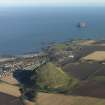
North Berwick Law


Field System (Prehistoric), House Platform (Prehistoric)(Possible), Hut Circle(S) (Prehistoric), Settlement (Prehistoric)
Site Name North Berwick Law
Classification Field System (Prehistoric), House Platform (Prehistoric)(Possible), Hut Circle(S) (Prehistoric), Settlement (Prehistoric)
Canmore ID 56674
Site Number NT58SE 10
NGR NT 555 840
Datum OSGB36 - NGR
Permalink http://canmore.org.uk/site/56674


- Council East Lothian
- Parish North Berwick
- Former Region Lothian
- Former District East Lothian
- Former County East Lothian
NT58SE 10 555 839.
(NT 555 839) Hut Circles (NR)
OS 6" map (1968)
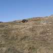
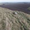
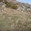
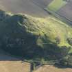
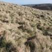
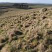
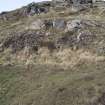
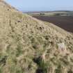
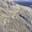
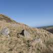
On the S slopes of North Berwick Law are many rock-faced terraces, some of which appear walled, others scooped to form huts or enclosures. On the SW shoulder are two adjoining, stone-walled rectangular enclosures measuring 33ft by 25ft and 22ft by 15ft. Further up the hill are three roughly circular stone-walled enclosures varying from 18ft in diameter to 33ft. On the same level, to the W, is a roughly quadrilateral area 18ft to 20ft across, enclosed by a setting of seven stones, with an entrance in the E wall.
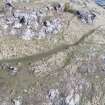
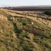
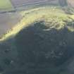
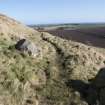
Along the S base of the Law are many stone foundations and kitchen middens. A saucer-shaped midden was found in a quarry; finds, donated to the NMAS in 1923 by Dr Richardson, included assorted bone and stone implements.
RCAHMS 1924, visited 1913; J S Richardson 1907; Proc Soc Antiq Scot 1924
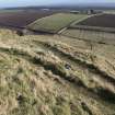
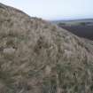
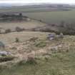
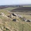
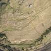
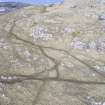
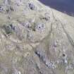
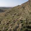
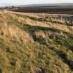
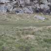
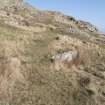
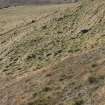
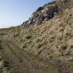
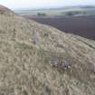
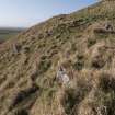
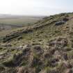
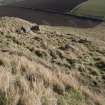
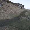
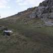
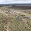
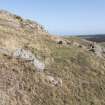
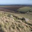
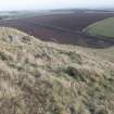
Spread over the lower southern slopes of North Berwick Law are five groups of hut circles and enclosures, totalling twenty-one individual structures. A few are oval, but most are circular, varying from 8.0m to 13.0m in diameter; all are scooped. There are indications of cultivation in the form of wasted banks forming strip fields towards the E end of the settlement.
Visited by OS (SFS) 13 July 1975
Field Visit (11 November 1913)
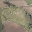
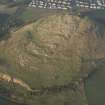
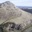
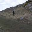
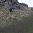
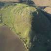
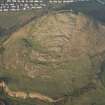
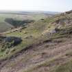
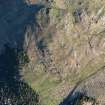
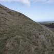
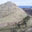
Barely a mile to the south of North Berwick is North Berwick Law a conical mass of basalt, rising to a height of 613 feet above sea-level and about 400 feet above the level land adjoining. A great part of its surface is rocky and steep, but towards the south and south-west, near the base, are stretches of gentle grassy slopes with numerous small terraces or benches above, which are faced with rock. Many of these benches seem to have been walled in to form enclosures either for human habitation or for cattle or sheep-folds; others show traces of walls on the ends and lower sides only, and some are slightly excavated on the upper side as well. As they are commanded by the higher ground above, they can not have been for defensive purposes. On the south-western shoulder of the hill, about 100 feet above the road which gives access to the Law, on a moderate grassy slope, are two adjoining rectangular enclosures walled on the ends and along the lower side and slightly excavated on the upper side. The walls have been of stone, but these have nearly disappeared, and the remains are overgrown with grass. They are placed end to end the longer axis running north-west and southeast. The larger enclosure lies to the south-east and measures 33 feet in length by 25 feet in breadth. It is entered by a gap, 6 feet wide, in the south-eastern end. The wall at present shows a width of about 7 feet and rises only a few inches above ground. At the south-western corner a flat stone set on edge seems to indicate the outer face of the wall at this place. A doorway, 4 feet wide, in the north-western end, leads into the smaller enclosure which is 22 feet in length by 15 feet in breadth, the excavated north-eastern side of both enclosures being in line. Several slabs set on edge on the south-western or lower side show the line of the wall. Near the north-western corner a small part of the end wall is exposed and shows several courses of flat stones carefully built. On a higher bench on the southern side of the hill, three roughly circular areas walled with stone, lie close to one another in a line running in an easterly and westerly direction. The most easterly enclosure is some 18 feet in diameter internally, the next is 27 feet in diameter, and the third, which is oval, is 33 feet by 27 feet. On the southern arc of the latter a portion showing both faces of wall near the foundation measures 4 ½ feet in breadth. To the westward, about the same level, is a roughly quadrilateral area, 18 to 20 feet across, enclosed by a setting of seven stones, which vary from 5 feet to I foot 10 inches in length and are set on the long edge. The entrance, 6 feet wide, seems to have been in the eastern wall.
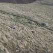
Along the southern base of the Law, between the rocky outcrops and the large quarry that skirts the hill on this side, is a gentle slope covered with a luxuriant growth of grass. Many stone foundations of large and small enclosures can be traced here, and the lower part of the slope is covered with kitchen middens containing very many animal bones and shells of the limpet and whelk (1).
Where the ground has been tirred preparatory to quarrying, great numbers of bones of animals are seen in the face of the cutting. One section above the rock of the quarry shows 18 inches of reddish stony soil covered with a stratum of broken stone 6 inches thick above which is a layer 1 ½ feet at least of dark soil. This intermediate band of stone extends probably 30 or 40 yards east and west, and the question is whether it is a geological formation or a human floor. The stone is the same as in the quarry. Under this floor a number of bones were seen, including the scapula of an animal.
RCAHMS 1924, visited 11 November 1913.
(1) See further Proc. Soc. Antiq. Scot. vol. xli.(1906-7) pp. 424-30.
Desk Based Assessment (2001)
A desk based assessment was undertaken as part of the project.
Sponsors: North Berwick Community Council, East Lothian Council.
C Lowe and J Morrison 2001
Ground Survey (2001)
A total of 13 sites or groups of sites were identified during the course of the field survey. A detailed plot was made of the later prehistoric settlement (NMRS NT58SE 10) on the S flank of the Law. Previously unrecognised elements of the Napoleonic-period signalling station (NMRS NT58SE 66) on the summit were traced. An element of the early 18th-century plantation on the NE side of the Law was also identified.
Sponsors: North Berwick Community Council, East Lothian Council.
C Lowe and J Morrison 2001
Archaeological Evaluation (2001)
An archaeological evaluation and watching brief were subsequently carried out on the NE slope of North Berwick Law prior to a programme of tree planting. A hand-dug trench, 6 x 1m, was excavated across a bank, thought to be the boundary of a plantation established in 1707. The profile of the bank was recorded. Two pieces of flint and a copper-alloy buckle were found within topsoil deposits.
Sponsors: North Berwick Community Council, East Lothian Council.
C Lowe and J Morrison 2001
Test Pit Survey (2001)
Twelve test pits, 0.5 x 0.5m, were excavated across the area to be planted. No archaeological deposits or finds were encountered.
Full details lodged with the NMRS.
Sponsors: North Berwick Community Council, East Lothian Council.
C Lowe and J Morrison 2001
Excavation (5 September 2012 - 11 November 2012)
NT 55461 83963 A programme of archaeological work was undertaken 5 September – 11 November 2012 on the midden on the S face of North Berwick Law. The midden deposits relate to an area of Iron Age settlement which has eroded and spread down a modern quarry face. The dry sieving of spoil from the midden was undertaken with assistance from over 100 children from the local primary school (Law Primary School). Further work was undertaken with the East Lothian and Edinburgh Young Archaeologists Clubs.
A number of finds including pottery, shell and animal bone (worked and unworked) were recovered. These will be amalgamated with antiquarian and casual finds, to provide information that will help in the formation of a management plan for the site. A topographical survey of the midden is planned to complement surveys undertaken in 1954 and 2000, and to quantify erosion rates. A programme of coring, designed to examine the potential survival of environmental remains, is also planned.
Archive: East Lothian Council Archaeology Service and RCAHMS
Funder: East Lothian Council Archaeology Service
Andrew Robertson, East Lothian Council Archaeology Service
2012
Note (3 April 2017)
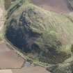
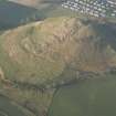
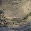
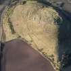
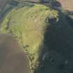
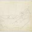
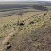
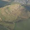
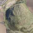
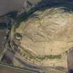
The distinctive cone of North Berwick Law, which rises abruptly above the surrounding countryside from a height of about 65m to its summit at 187m OD, is the site of a large fort. Its defences are fragmentary, according to Richard Feachem, who drew up a plan for RCAHMS in 1954, comprising three ramparts: the first encircles the summit of the hill; the second takes in a lower terrace on the SW; and the third drops down on either flank to enclose the lower slopes on SW, including a broad terrace extending out to the lip of the disused Law Quarry. Feachem notes that the inner rampart encloses an area measuring about 150m from NE to SW by 90m transversely (1963, 119), though there is little trace of it along the rocky NW and SE flanks, and the last sight of the SW side on the SE would suggest a rather large transverse measurement in the order of 135m (1.7ha). The second rampart on the SW is more fragmentary, and while aerial photographs indicate a band of stony debris about 60m further down the slope from the inner, a survey carried out by Headland Archaeology in 2000-1 failed to identify any trace of a rampart here (Lowe and Dalland 2001; archived RCAHMS MS1039/72). The leading edge of the third rampart has been destroyed by the quarry along most of the SW side, but finds from exposures in the quarry revealed midden and other evidence of occupation leading, while on both the W and E the course of the rampart can be followed, forming a terrace climbing obliquely up the slope. The greater part of the interior is bare rock outcrop, but on the lower slopes within the compass of the third rampart, which encloses an overall area of about 9.4ha, a series of hut-circles and house platforms can be seen strung across natural terraces on the lower slopes on the S, while on the gentler slope below them at least two lynchets of a small field-system can also be distinguished. The only entrance visible in the lower rampart lies on the SE, giving access to the lower slopes on the S from the E; the entrances through the upper ramparts are probably marked by clefts in the outcrops taken by modern footpaths. The quarrying at the foot of the slope exposed midden in deposits up to 0.7m deep.
Information from An Atlas of Hillforts of Great Britain and Ireland – 03 April 2017. Atlas of Hillforts -SC3896
Field Visit (May 2018)
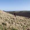
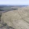
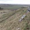
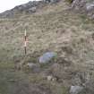
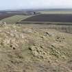
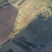
The southern flank of North Berwick Law is the location for a prehistoric settlement of at least 13 structures, vestiges of a contemporary field system, and indications of later cultivation and enclosure. The settlement is spread over an area that measures about 290m from E to W by 60m transversely at heights of between 80m and 105m above sea level. It is bounded to the S by the post-medieval quarry (NT58SE 136), to the E and W by steeper slopes, and to the N by rocky and broken ground topped by a prehistoric fort (NT58SE 32). Each of the structures is described in the accompanying database (DT 000141; WP 005305), but a summary is provided here.
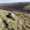
The structures include both hut circles and house platforms, and at least one enclosure. The majority are circular or oval on plan, with only two being sub-rectangular (Features 1.12 and 1.24). They range in size up to about 9m across the slope by 7m transversely and the hut circle walls comprise either a low stony bank 2m in thickness or a fragmentary wall incorporating very large boulders (e.g. 1.6). Four of the structures stand on prominent mounded platforms (e.g. 1.11), with stone revetment along their lower edge, while others are only visible as level platforms set into the slope (e.g. 1.15-1.17). In one case, a hut circle stands within a small enclosure (1.8), and in another a hut circle (1.2) can be seen to overlie another (1.1). The buildings have previously been compared with those at Dreva in the Scottish Borders (RCAHMS 1967, 114; NT13NW 8.01).
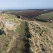
The features of the field system cover about 1.5ha and comprise as many as 10 small cairns associated with at least four stretches of boulder bank (centred NT 554 839). Further to the E there are at least five stretches of linear bank, running up and down the slope, and two small cairns (NT 556 839). A series of small scoops dug into scree along the N edge of the field system (NT 5564 8406) are probably later quarries and appear to be associated with a bank of no great age which runs across the hillside from ENE to WSW.
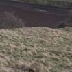
The smoothness of the ground and the lack of earlier features indicate that the lowest slopes here have been cultivated in relatively recent times, and a plough scarp is visible along much of the area, up to 55m N of the quarry edge and running from E to W. A stone dyke (Feature 2) runs for a distance of about 185m from S to N bisecting the cultivated ground, and this probably corresponds with the boundary shown on an estate map of 1804 (NRS RHP 1726; NT58SE 144).
The settlement was first noted in passing by J S Richardson (1907), and 7 structures were noted by RCAHMS in 1913 (1924, 72). Having discovered the fort on the summit in 1954, RCAHMS then surveyed as many as 26 structures in this area (Drawing ELD 2/3). In 1975 the Ordnance Survey recorded 21 of these, all of which are depicted on the current edition of OS Mastermap, albeit with varying degrees of accuracy. In 2000 Headland Archaeology Ltd identified 16 structures – a 17th identified as a new discovery had already been surveyed in 1954. Each of these features has been located, surveyed and re-assessed in the current survey. Out of the total of 26 features recorded in 1954, 15 have been accepted as structures, two as banks, and 9 as probably natural features.
As yet no firm evidence has been found to date the settlement. Hazelgrove (2009, 219) has suggested that it is Roman Iron Age in date, but this is based purely on typological similarities between this site and others, all further south, that are firmly dated. Much earlier activity on and around the south flank of the hill is indicated by the discovery, on two separate occasions, of Late Bronze Age socketed axes, one discovered with a bone bead (NT58SE 15; NT58SE 33). However, the bronze leaf-shaped sword (NT58SE 31) said to have been found on the ‘upper part’ of North Berwick Law could as easily be Middle Bronze Age in date as LBA. Judgement must be reserved as far as the midden material, bone and horn implements, pottery and flint tools is concerned (Richardson 1907; RCAHMS 1924, No. 110). Some of it (pottery and flints) are probably prehistoric, but the bone artefacts, the animal remains and the large quantities of shell could be of more recent antiquity.
Visited by HES Survey and Recording (GFG, JRS, AM, LB) May 2018.
(NBL 1.01-1.28)

