
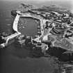
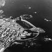
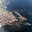
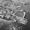
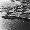
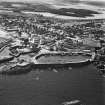
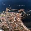
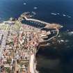
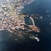
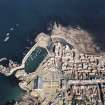
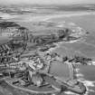
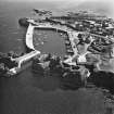
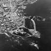
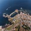
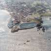
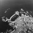
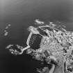
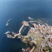
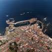
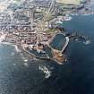
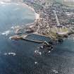
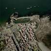
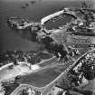
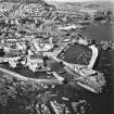
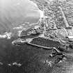
Dunbar, Harbour, Lamer Island, Battery


Battery (18th Century), Hospital (First World War), Infectious Diseases Hospital (19th Century)
Site Name Dunbar, Harbour, Lamer Island, Battery
Classification Battery (18th Century), Hospital (First World War), Infectious Diseases Hospital (19th Century)
Alternative Name(s) Dunbar, Old Harbour; Cromwell's Harbour; Broadhaven; Lamer Island Hospital: Battery Hospital: Hospital (Infectious Diseases); Casual Sick House
Canmore ID 57657
Site Number NT67NE 53
NGR NT 68122 79349
Datum OSGB36 - NGR
Permalink http://canmore.org.uk/site/57657


- Council East Lothian
- Parish Dunbar
- Former Region Lothian
- Former District East Lothian
- Former County East Lothian
NT67NE 53 68112 79348
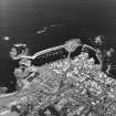
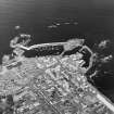
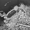
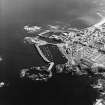
See also NT67NE 18 and NT67NE 147 : this battery is situated between the two harbours at Dunbar.
Not to be confused with Dunbar Castle (NT 6782 7930), for which see NT67NE 8.
(NT 6811 7934) Battery (NAT) (rems of)
OS 6" map (1971)
This fort was erected in 1781 to protect the town of Dunbar from sudden invasion but more particularly to protect it from privateers. The battery mounted sixteen guns of differing calibres which were removed to Edinburgh when the fort was dismantled at the end of the Peninsular War.
Name Book 1853; NSA 1845 (J Jaffray)
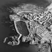
The remains of this 18th century battery consist of a strong wall surrounding the site with an archway (with beam-holes in the jambs) to the W and embrasures for cannon in the other three sides. Internally the stone platforms for the guns and vaulted apartments are still visible and detail on the walls shows where roofed buildings had at one time abutted. The remains are in good condition.
Surveyed at 1:2500.
Visited by OS (DT) 28 August 1962.
The Battery, on Lamer Island, was built after an American ship had attempted to raid the harbour in 1781. It is a red-sandstone structure with an open gun-platform, embrasures for sixteen guns, and a covered magazine and quarters for the garrison.
A Graham 1971
Fort erected in 1781. Generally as described in RCAHMS. The site was not visited because the swing bridge was open. However the remains appeared to be in good condition except for two walls extending from the main building to these which are eroding at the seaward end.
Site recorded by GUARD during the Coastal Assessment Survey for Historic Scotland, 'The Firth of Forth from Dunbar to the Coast of Fife' 1996.
NT 6811 7934 A programme of historic building recording work was required as part of a conservation plan for the
development of Lamer Island as a visitor centre. The survey from 18-24 September 2007 identified that the D-shaped Battery underwent at least four phases of alteration as it developed from a late 18th-century military battery fortification into an invalid hospital for soldiers during the First World War. Many of the footings and features of its military life were present, although often in a fragmented form. All standing remains of the hospital structure have been removed, although the presence of a central drain and channels for iron framing are still visible in the fabric of the building.
An archaeological evaluation was also required and investigated a total area of 59m2 on the island. A number of previously unknown structural archaeological remains were recorded, such as a blocked-off passageway or guardroom and stone settings for a wooden gantry or platform. The original floor surface of the upper level of the battery was recognised. An exterior cottage structure was also investigated.
Archive to be deposited with RCAHMS.
Funder: Dunbar Harbour Trust.
Rob Engl and Suzanne Lilley, 2007.
Publication Account (2006)
A battery was built on Lamer Island in 1781, principally to protect the town from privateers during the later stages of the American War of Independence. It has a rounded seaward front designed to deflect artillery and is fitted with several embrasures for heavy guns. In later times the structure was used as an isolation hospital and for invalids returning from the First World War. The structure has been listed category 'B'.
Information from ‘The Scottish Burgh Survey, Historic Dunbar: Archaeology and Development’, (2006).
Watching Brief (1 October 2007 - 27 February 2008)
In 2007 a programme of historic building recording work was commissioned by the Dunbar Harbour Trust as part of a Conservation plan which is being prepared prior to the development of the site as a visitors centre. These works were required as part of the objectives of a stage one lottery grant. Dunbar Harbour Trust have asked East Lothian Council Archaeology Service (ELCAS) to advise on the archaeological works required. The works will be undertaken by AOC Archaeology Group and overseen by the Dunbar Harbour Trust, advised by Ms Biddy Simpson of ELCAS. The work was undertaken by AOC Archaeology Group on the 18thSeptember 2007. The survey identified that the D-shaped Battery (red sandstone ashlar faced and rubble core) underwent at least six phases of alteration as it developed from a late 18th century military Battery fortification to become an invalid hospital for soldiers during the First World War. The Battery became ruined after a fire in 1937 which destroyed the hospital building. Many of the footings and features of its military life are present although often in a fragmented form. All standing remains of the hospital structure have been removed, although the presence of a central drain and channels for iron framing are still visible in the fabric of the building.
AOC Archaeology Group (A. Rardin) OASIS ID: aocarcha1-50851
Archaeological Evaluation (18 September 2007 - 24 September 2007)
NT 6811 7934 A programme of historic building recording work was required as part of a conservation plan for the development of Lamer Island as a visitor centre. The survey from 18-24 September 2007 identified that the D-shaped Battery underwent at least four phases of alteration as it developed from a late 18th-century military battery fortification into an invalid hospital for soldiers during the First World War. Many of the footings and features of its military life were present, although often in a fragmented form. All standing remains of the hospital structure have been removed, although the presence of a central drain and channels for iron framing are still visible in the fabric of the building.
An archaeological evaluation was also required and investigated a total area of 59m2 on the island. A number of previously unknown structural archaeological remains were recorded, such as a blocked-off passageway or guardroom and stone settings for a wooden gantry or platform. The original floor surface of the upper level of the battery was recognised. An exterior cottage structure was also investigated.
Archive to be deposited with RCAHMS.
Funder: Dunbar Harbour Trust.
Archaeological Evaluation (25 April 2016)
AOC Archaeology Group was commissioned by Dunbar Harbour Trust to undertake a programme of archaeological trial pitting related to site investigation works at Lamer Island, Dunbar, East Lothian (NGR; NT 6811 7934). A series of seven 1 m by 1 m trial-pits were hand excavated across the 18th century Battery uncovering a series of wall foundations, flagstone floors and formation levels.
Information from OASIS Id: aocarcha1-250545 (R Engl) 2016
Watching Brief (13 September 2016 - 24 February 2017)
NT 68113 79358 A watching brief was undertaken, 13 September 2016 – 24 February 2017, during the excavation of the former medieval battery of Lamer Island, prior to and during consolidation works. A previous test pit survey in June 2016 had discovered a series of wall foundations, flagstone floors and formation levels together with some 18th- and 19th-century pottery sherds. An element of historic building recording was also undertaken of the exposed vaults, which were discovered after the removal of a blockage to their main entrance on the SE side of the battery. The excavations also uncovered the base of previously obscured walls to the centre of the battery and a small room to the S corner.
The battery was reused in the later 19th century as a hospital. The hospital consisted of the main two-storey block to the SE of the structure with its associated vaults (a former magazine) also reused, together with a large building to the S corner, which was used as a fumigation house for the hospital.
The excavations exposed a number of original features and the original floor levels of all three of the structures. The excavations to the N of the site identified the remnants of walls, which probably related to the hospital building, as well as six gun-emplacements in good condition. The excavations to the main entrance to the exterior SW side of the battery entrance identified the foundation of a small structure, probably cottages for the hospital.
Archive: NRHE (intended)
Funder: Dunbar Harbour Trust
Diana Sproat and Anne-Aymonne Marot – AOC Archaeology Group
(Source: DES, Volume 18)
Watching Brief (13 September 2016 - 24 March 2017)
AOC Archaeology Group was commissioned by the Dunbar Harbour Trust to undertake an archaeological watching brief on the excavation of the former battery of Lamer Island in Dunbar East Lothian, prior to and during consolidation works on the site. The work follows on from a Conservation Plan undertaken by AOC in 2007 and a test pit survey undertaken in June 2016 which discovered a series of wall foundations, flagstone floors and formation levels together with some 18th and 19th century pottery sherds. An element of historic building recording was also undertaken of the exposed vaults building, which was discovered after the removal of blocking of the main entrance to it to the SE side of the battery. The excavations also uncovered the base of the previously obscured walls to the centre of the battery as well as the small room to the south corner of the battery.
Information from OASIS ID: aocarcha1-287559 (R Murray) 2017

