
Pricing Change
New pricing for orders of material from this site will come into place shortly. Charges for supply of digital images, digitisation on demand, prints and licensing will be altered.
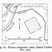
Easter Cadder


Temporary Camp (Roman)
Site Name Easter Cadder
Classification Temporary Camp (Roman)
Alternative Name(s) Antonine Wall; Park Burn; Adamslie; Adamslee; Westermains
Canmore ID 45256
Site Number NS67SW 24
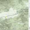
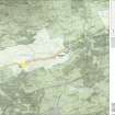
NGR NS 64400 73470
Datum OSGB36 - NGR
Permalink http://canmore.org.uk/site/45256


- Council East Dunbartonshire
- Parish Cadder (Strathkelvin-du)
- Former Region Strathclyde
- Former District Strathkelvin
- Former County Lanarkshire
NS67SW 24 64400 73470
See also NS67SW 45.00 (Antonine Wall).
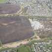
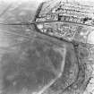
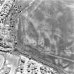
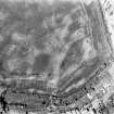
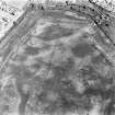
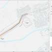
NS 644 735 Roman Temporary Camp, Easter Cadder (Site): This camp is situated at the north east end of a low ridge, 130m south east of the point where the Antonine Wall crossed Park Burn. No trace of the structure can now be seen on the surface, but most of the perimeter has been revealed by crop marking on air photographs (CUCAP, WA86 WC 2, RCAHMS LA 1414-5: flown 1976, LA 1982-4: flown 1977). The camp measured some 122m in length from north north west to south south east by 113m transversely, the area enclosed being approximately 1.4ha (3.5 acres). The positions of the gates, at least one of which appears to have been protected by a titulum, indicate that the camp probably faced north north west. Although significantly smaller than camps of the series discovered at the end of Antonine Wall, it may possibly have accommodated one of the legionary vexillations engaged in the construction of that frontier.
RCAHMS 1978.
NS 6440 7347 No surface trace across open field under young crop. No crop marks distinguishable.
Surveyed at 1:2500 and 1:1250 from RCAHMS air photographs.
Visited by OS (J R L), 20 June 1980.
[Formerly Scheduled as Adamslie Roman camp (Antonine Wall)]. Scheduled with length of Antonine Wall from NS c. 63562 73004 to NS c. 64223 73575 (NS67SW 45.00), Roman fortlet (NS67SW 21), and henge (NS67SW 27).
[Location map supplied].
Information from Historic Scotland, scheduling document dated 25 June 2010.
Aerial Photography (1 August 1957)
Aerial Photography (31 July 1957)
Aerial Photography (1957)
Aerial Photography (29 July 1970)
Field Visit (October 1976)
NS 644 735. Roman Temporary Camp, Easter Cadder (Site): This camp is situated at the north east end of a low ridge, and only 130m south east of the point where the Antonine Wall crossed Park Burn. No trace of the structure can now be seen on the surface, but most of the perimeter has been revealed by crop marking on air photographs (CUCAP, WA86 and WC 2, RCAHMS LA 1414-5). The camp measured some 122m in length from NNW to SSE by 113m transversely, the area enclosed being approximately 1.4ha (3.5 acres). The positions of the gates, at least one of which appears to have been protected by a titulum, indicate that the camp probably faced NNW. Although significantly smaller than camps of the series discovered at the end of Antonine Wall, it may possibly have accommodated one of the legionary vexillations engaged in the construction of that frontier.
RCAHMS 1978, visited October 1976.
Aerial Photography (21 July 1977)
Aerial Photographic Interpretation (20 June 1980)
Surveyed at 1:2500 and 1:1250 from RCAHMS air photographs.
20 June 1980.
Field Visit (20 June 1980)
NS 6440 7347 No surface trace across open field under young crop. No crop marks distinguishable.
Visited by OS (J R L) 20 June 1980.
Note (1982)
Easter Cadder, Adamslie, Temporary Camp NS 644 735 NS67SW 24
This small camp, which was first identified from cropmarks, is situated to the SE of the Antonine Wall about 1 km E of Easter Cadder; measuring 122m by 113m, it enclosed an area of 1 .4ha, and probably accommodated legionary troops engaged in the construction of the wall.
RCAHMS 1982
(RCAHMS 1978, p. 134, No. 256)
Publication Account (2008)
A 1:25000 scale map of the Antonine Wall was published by RCAHMS in 2008. The map shows the course of the Antonine Wall on a modern map base, including areas where the Wall is in public ownership or care and can be visited. The data had been collated as part of the project to prepare maps for the World Heritage Site nomination bid.
Aerial Photography

