
Pricing Change
New pricing for orders of material from this site will come into place shortly. Charges for supply of digital images, digitisation on demand, prints and licensing will be altered.
Knock Farril


Fort (Prehistoric), Vitrified Stone (Prehistoric)
Site Name Knock Farril
Classification Fort (Prehistoric), Vitrified Stone (Prehistoric)
Alternative Name(s) Knockfarrel
Canmore ID 12782
Site Number NH55NW 10
NGR NH 5045 5850
Datum OSGB36 - NGR
Permalink http://canmore.org.uk/site/12782


- Council Highland
- Parish Fodderty
- Former Region Highland
- Former District Ross And Cromarty
- Former County Ross And Cromarty
NH55NW 10 5045 5850.
(NH 5045 5850) Vitrified Fort (NR)
OS 6" map, (1959)
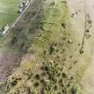
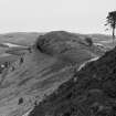
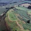
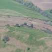
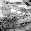
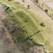
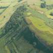
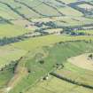
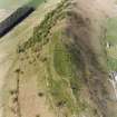
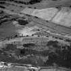
A vitrified fort within the remains of a probably earlier fort, on the summit of Knock Farril, a ridge running NE-SW.
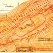
The vitrified fort (of enigmatic plan according to Feachem (R W Feachem 1963)) is sub-rectangular on plan measuring c. 116.0m NE-SW by c. 30.0m within a heavily vitrified wall averaging c. 4.5m in thickness. No wall faces are evident. It is alleged (visited by OS (R D) 19 January 1965) that the entrance is probably in the SW but this cannot be established, although it is likely as this is the easiest approach. Extending NE along the spine of the ridge from the NE side of the fort for a distance of c.25.0m is a vitrified wall which links the fort with what appears
to be a sub-rectangular vitrified enclosure measuring internally about 25.0m NE-SW ab 5.0m. Traces of a similar arrangement overlaid by a modern track exist at the SW end of the fort. Here vitrifaction can be seen extending for a distance of c.50.0m from the fort and terminating on an area of turf-covered tumble on a knoll. Outer facing stones are visible for c.8.0m about halfway along on the SE side. These outworks probably represent "look-out posts" similar to that at An Torr (NM66NE) as they overlook the NE and SW approaches, both out of sight of the fort itself.
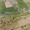
In the SW half of the interior of the fort is a mutilated cistern c. 5.0m in diameter. Close by to the SW are what may be the footings of a rectangular building c.8.0m by c.5.0m with a sub-circular hollow c.7.0m in diameter on its NE side, although these could be due to quarrying. It is alleged (Visited by OS (R D) 19 January 1965) that there are two circular enclosures, one overlying the fort wall in the NE, and the other outside it in the SW, but both of these are recent mutilations. The fort is overlaid by three widely spaced ditches of uncertain date and purpose, running NW-SE across the spine of the ridge. Each has the spoil thrown on to its SW rim, forming a slight rampart. The most north-easterly ditch cuts through the vitrified walling at the SW side of the NE "look-out post". An entrance gap c.2.0m wide has been left midway, on the spine of the ridge, typical of the entrance to a fort. The central ditch crosses the NE part of the fort cutting through the vitrified wall in the NW and SE. A gap in the centre of the rampart appears to be a mutilation as there is no corresponding causeway across the ditch.
The SW ditch cuts through the vitrified walling on the SE side of the spine of the ridge halfway along the projecting wall at the SW end of the fort.
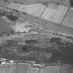
Outside the fort are traces of another wall, not vitrified, which probably represents the remains of an earlier fort robbed to build the vitrified fort. Its course is marked along a change in slope on the SE side of the hill by a rickle of stones, which is most evident between the SE extremity of the central ditch and midway along the SW ditch which cuts through it. Outer wall facing stones are visible intermittently for a distance of c.27.0m. It can be traced to the NE along the same change in slope as far as the NE ditch, and also to the SW where it turns N around the base of the knoll occupied by the SW "look-out post", from where there are indications that it continued towards the NW corner of the vitrified fort whose NW side probably overlies it.
Outside all the defences in the SW are the remains of a curving wall which bars the SW approach. There was probably a means of access around either end of this wall where it stops short of the steeper slopes. It is not vitrified and it is uncertain with which phase it is contemporary.
Resurveyed at 1:2500.
Visited by OS (A A) 1 December 1970.
No change.
Visited by RCAHMS (J R S) March 1989.
Field Visit (September 1978)
Knock Farril NH 504 585 NH55NW 10
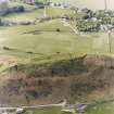
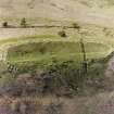
The remains of this complex multi-period vitrified fort occupy the summit of Knock Farril.
RCAHMS 1979, visited September 1978
(Feachem 1977, 148-9)
Publication Account (1995)
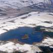
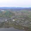
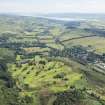
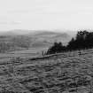
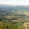
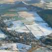
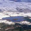
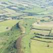
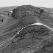
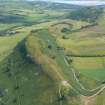
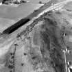
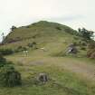
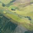
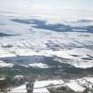
The fort occupies the summit of a ridge standing high above Strath Peffer with steep slopes to north and south but a gentler approach at the west end where the ridge continues. It is covered in grass which is a pleasant change from the tough heather of so many Highland forts.
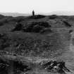
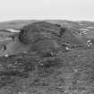
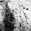
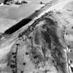
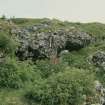
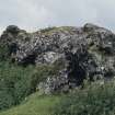
The fort is subrectangular in plan, and its stone rampart is heavily vitrified. Great masses of vitrified rock outcrop along the south rampart in particular, where in places stones can be seen to have partly melted, started to run out like thick treacle, and then solidified again. An unusual feature of this fort is that lines of vitrified rampart lead out east and west from either end. These may have been ramparts with breastworks each side, built to prevent attack along the narrow spine of the ridge. There are traces of an outer rampart round part of the circuit. Modern scientific tests (thermo-Iuminescence dating) of the vitrified stone suggest the main rampart may belong to the bronze age, but more evidence is needed. The plan of the fort is confused by three later ditches which cut across the fort from side to side: one ditch cuts across the vitri fied wall east of the fort, one across the fort itself and the other across the western wall, each with a bank on its west side. These were trenches excavated by the engineer John Williams in the 1770s as part of an early attempt to understand vitrified forts. He suggested that there was a gap between the main rampart and the end walls, so that they could be cut off if necessary by removing a drawbridge.
Inside the fort, a pond in the western half was probably a rock-cut cistern to hold rain water. West of the pond are the foundations of two more recent structures.
Information from ‘Exploring Scotland’s Heritage: The Highlands’, (1995).
Ground Survey (21 June 2011 - 22 June 2011)
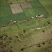
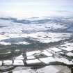
NH 5045 5850 and NH 6640 4910 A detailed topographic survey was undertaken 21–22 June 2011 of two Pictish forts on the Black Isle. These were Knock Farril, near Dingwall and Ord Hill, near North Kessock. The surveys provided a baseline record of the earthworks and surviving structural features of the forts. This data will be used in any future access and interpretation initiatives and assist with conservation management of the sites.
Both forts are situated on very prominent ridges and would have offered commanding views over their respective surroundings. Substantial remnants of (at least) partly vitrified enclosure walls and outworks are still visible at each site. There were no clear signs of contemporary internal features in either fort. The sites currently provide very different visitor experiences. Knock Farril offers clear views of both the environs and the layout of the fort, while Ord Hill’s afforested summit makes comprehension of the site and its setting more difficult.
Archive: RCAHMS
Funder: Forestry Commission Scotland
Headland Archaeology Ltd, 2011
Note (9 March 2015 - 31 August 2016)
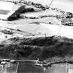
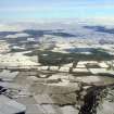
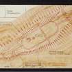
This fort occupies the summit of the ENE end of a long ridge overlooking Strathpeffer from the SE. Lozenge-shaped on plan, it measures about 118m from NE to SW by 30m transversely (0.33ha) within a heavily vitrified wall with massive exposures of vitrifaction all around its circuit. At either end wing walls extend along the crest of the ridge for a distance of at least 50m, in effect doubling the length of the fort in terms of its visual impact from the valley below. No entrance is visible but two wells are visible within the SW end of the interior, and there are traces of a rectangular building adjacent to one of them. Though it is not shown on the most recent survey (Headland 2013, fig 3b), Alan Ayre of the OS also identified traces of what he thought might be an earlier rampart or wall extending along a break of slope on the E flank of the fort and hooking round beneath the end of the wing wall at the SW end; in one place he identified its outer face over a distance of some 27m. In contrast to the inner wall, there was no trace of vitrifaction in this line of defence, and nor is there in a short segment of rampart set astride the spine of the ridge outside it at the SW end. In addition to the remains of the fort itself, evidence of at least two excavation trenches dug by John Williams about 1777 can be seen, one cut across the fort from side to side a little NE of its centre, and the other driven into the SW wing wall from the SE. A third similar feature cuts across the NE wing wall, but if this is an excavation rather than a more ancient boundary work of some kind spanning a relatively narrow part of the ridge top, it seems to date from before Williams' time (1777, 30). Williams measured the heights of the walls in his trenches, which were cut down to bedrock, observing that even in its ruined state the wall on the N side was some 3.5m in height, while the wing wall on the SW was 7m in height. He also dug into both wells, which filled up with water overnight.
Information from An Atlas of Hillforts of Great Britain and Ireland – 31 August 2016. Atlas of Hillforts SC2888

