
Following the launch of trove.scot in February 2025 we are now planning the retiral of some of our webservices. Canmore will be switched off on 24th June 2025. Information about the closure can be found on the HES website: Retiral of HES web services | Historic Environment Scotland
Kirk Stones


Settlement (Period Unassigned)
Site Name Kirk Stones
Classification Settlement (Period Unassigned)
Alternative Name(s) Stroupster
Canmore ID 9355
Site Number ND36SW 6
NGR ND 3267 6475
Datum OSGB36 - NGR
Permalink http://canmore.org.uk/site/9355


![Watercolour of a stone-built structure in plan, to scale [a quarter inch to one foot], entitled: 'No.4'. A hand-written description at the foot of the page reads: "8 feet square. 3 ft 10 in. Height to 3 ft. Seat Length 3 ft. Height 1 ft 4 in by 1 ft 7 in. Scarcement from 7 in. to 9 in Depth. 1 ft width".](http://i.rcahms.gov.uk/canmore/l/SC00876539.jpg)


![Plan of a stone-built structure No. 3 to scale [a quarter inch to one foot]. A hand-written description at the foot of the page reads: "me[a]sures from 6 ft to 8 ft. Height of Wall 3 to 2 feet. Seat 8 in. by 1 ft."](http://i.rcahms.gov.uk/canmore/l/SC00876533.jpg)


![Watercolour of a stone-built structure in plan, to scale [a quarter inch to one foot], entitled: 'No.4'. A hand-written description at the foot of the page reads: "8 feet square. 3 ft 10 in. Height to 3 ft. Seat Length 3 ft. Height 1 ft 4 in by 1 ft 7 in. Scarcement from 7 in. to 9 in Depth. 1 ft width".](http://i.rcahms.gov.uk/canmore/s/SC00876539.jpg)


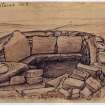
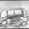

![Plan of a stone-built structure No. 3 to scale [a quarter inch to one foot]. A hand-written description at the foot of the page reads: "me[a]sures from 6 ft to 8 ft. Height of Wall 3 to 2 feet. Seat 8 in. by 1 ft."](http://i.rcahms.gov.uk/canmore/s/SC00876533.jpg)


- Council Highland
- Parish Wick
- Former Region Highland
- Former District Caithness
- Former County Caithness
ND36SW 6 3267 6475.
(ND 3267 6475) Kirk Stones (NR) Supposed Site of Chapel (NR)
OS 6" map, Caithness, 1st ed., (1868)
An alleged ecclesiastical complex comprising a group of four structures, one of which is said to be a chapel. A stone wall encloses the top of the green knoll, 50 yds by 30 yds, on which the site lies, and the whole is enclosed by a ditch. Many large stones, some of them set on edge, lie within the enclosure.
The walls of the building exist to a maximum height of about 3'. The batter on the outer faces and the number of small stones found in the interiors suggest that the roofing has been of the beehive type.
The excavation of the alleged chapel (No 1 on Nicolson's plan) was begun by Laing before 1866 and was completed by Sir Francis Tress Barry. It revealed a paved structure about 11' square within a 4'6" thick wall, its WSW entrance approached by a 13' long passage, 2' wide at the inner end and 3'6" wide at the outer. Against the back wall of the chamber, three slabs 1'6" - 2' high are set edge-on to the wall. The thickness of the walls on either side of the passage is indeterminate, but at 6'7" to the left, the face of a wall, running parallel for a distance of 16' has been exposed (Nicolson 1916).
Laing reported the finding of a row of boulders forming a bench or bed along the wall on each side of the interior, but of these there was no trace in 1910. A layer of domestic refuse, a foot in maximum thickness covered the floor and Laing recovered fragments of wheel-made pottery with a coarse blue glaze as well as shells, bones and ashes.
The other structures (Nos 2, 3 & 4) were cleared by Nicolson and proved to be generally similar though smaller, but the only finds were limpet shells especially from structure no. 4. All had scarcements and structure no. 3 had two floors levels. A small dyke ran off in a NW direction from the outer end of the passage of structure no. 2 (Nicolson 1916).
This is presumably the site referred to in the early 18th century as the site of "Kirk of Strubster" (Macfarlane 1906-8).
(Stroupster: ND 33 66) of which no remains of buildings were visible. Auld (1868) refers to the site as a hermitage. Former cultivation is visible for about 6 acres on either side of the Kirk Burn, with an adjacent foundation of a turf-built homestead over 50' long.
Two chains E of the burn is what appears to be a grave with a headstone 8" high and a footstone just level with the surface (Nicolson 1916).
S Laing 1866; RCAHMS 1911, visited 1910; J Nicolson 1916; W Macfarlane 1906-8; A Auld 1868.
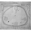
"Kirk Stones", a group of four structures within a sub-oval enclosure wall on a grassy rise on the S bank of the Kirk Burn.
The four structures are as described by the RCAHMS and Nicolson and survive in good order in their post-excavation condition. They are as planned by Nicolson. There appears to be indertminate traces of other structures, as yet unexcavated, in the immediate vicinity. As stated by the RCAHMS none of the four structures suggests an ecclesiastical edifice, Nicolson and Barry's interpretation of the larger building being a church is due to its larger size and to the tradition.
The oval enclosure wall survives as an ill-defined turf-covered rickle of stones which cannot now be traced in the N. The enclosed area measures 44.0m E-W by about 56.0m transversely. Apart from a slight depression in the S which could be due to water action there is no ground evidence of the ditch planned by Nicolson.
About 64.0m to the E of the 'church' on the S bank of the stream are the amorphous remains of a building of indeterminate size and character. In its NW corner is an upright slab which is presumably the 'headstone' referred to by Nicolson but which is actually part to the wall.
The fact that laing's sketches before and after excavation indicate that the structures were well covered by an accumulation of turf, suggests that they were not of recent origin - possibly the settlement of an Early Christian community, or even dating to prehistoric times.
About 180.0m NNE of the 'church' is a sub-rectangular ditched enclosure cut into a level peat bog, which is presumably the 'turf-built homestead' referred to by Nicolson. It consists of a ditch 6.0m wide, 0.3m deep in the NE narrowing to about 2.0m wide and 0.3m deep in the SW enclosing a sub-rectangular area measuring about 20.0m NW-SE by 25.0m transversely. There is a well-defined causeway about 3.0m wide halfway along the NE side. The date and purpose of this enclosure cannot be ascertained. It may be quite recent.
The only evidence of cultivation in the area is about 100m to the SW of the 'church' where there are faint traces of strip cultivation.
Surveyed at 1:10,000.
Visited by OS (I S S) 21 March 1972.
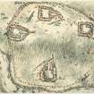
'The Kirk Stones': A low, grass-covered mound about 50m long, upon which five structures have been built, all of which show signs of robbing.
'A' (the SE structure, no. 1 on Nicolson's plan) is a mound 20m in diameter containing a square chamber, about 3.7m by 3.4m, with two vertical slabs defining three alcoves at its E end. An entrance passage more than 3m long enters the chamber centrally through its W wall. To the N of the entrance passage are indications of a possibly later passage leading to a small depression set near the NW corner of the main chamber.
'B' (the SW structure, no. 4 on Nicolson's plan) is a mound 12m by 20m and 1m high containing a rectangular chamber of drystone walling which measures 2.4 by 2.2m and has a possible entrance from the N.
'C' is an amorphous mound 7m in diameter and 1m high, with no visible stones. It is not precisely sited.
'D' (the NW structure, no. 2 on Nicolson's plan) is a mound 14m in diameter and 1m high containing a sub-rectangular chamber of orthostatic construction, measuring 2.3 by 3.3m and having a passage 4m long approaching from the S.
'E' (the SW structure, no. 3 on Nicolson's plan) is a mound 7m by 5m and 1.5m high, containing a trapezoidal chamber of orthostatic construction measuring 2.1 by 2.6m with a possible passage entering from the NW.
R J Mercer 1980.
The four excavated mounds containing structures (Mercer A, B, D and E) are as described by the previous field investigator and planned by Mercer and Howell. Mercer's mound 'C' is at ND 3264 6474; this is outside the enclosure comprising a stone dyke and ditch planned by Nicolson, but this enclosure can no longer be traced in the heather with any certainty. The enclosure 180m NNE of the 'church', tenuous in the extreme, is probably associated with nearby strip cultivation.
The date and purpose of the 'Kirk Stones' remain unclear. The isolation of the site and the proximity to a stream may suggest a shieling settlement, but the exposed structures are well-made and constructed of heavy stones, and as such are totally dissimilar to other Highland shielings. It is more likely to ba an ecclesisatical site as evidenced by the names and tradition (Kirk of Strubster, Kirk Stones, Kirk Burn); these names existed before the structures wer exposed by excavation. However, the structures are quite unlike the crude turf-built cells seen in the Northern Isles monastic sites. The enclosure bounding the four structures is typical of a cashel, though this is no longer traceable. The discovery of wheel-turned, glazed pottery (albeit unstratified) would indicate a later (historic) date.
Visited by OS (N K B) 23 August 1982.

