
Pricing Change
New pricing for orders of material from this site will come into place shortly. Charges for supply of digital images, digitisation on demand, prints and licensing will be altered.
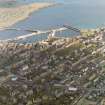
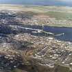
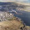
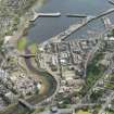
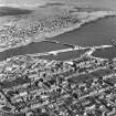
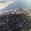
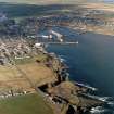
Wick Harbour


Harbour (19th Century)
Site Name Wick Harbour
Classification Harbour (19th Century)
Alternative Name(s) Wick Harbours; Lower Pultneytown; Wick Bay; Pultneytown Harbour; Wick River; Bay Of Wick
Canmore ID 9204
Site Number ND35SE 66
NGR ND 36820 50670
NGR Description Centred ND 36820 50670
Datum OSGB36 - NGR
Permalink http://canmore.org.uk/site/9204


- Council Highland
- Parish Wick
- Former Region Highland
- Former District Caithness
- Former County Caithness
ND35SE 66.00 centred 36820 50670
Inner Harbour [name: ND 3677 5068]
Outer Harbour [name: ND 3688 5054]
River Basin [name: ND 3680 5085]
North River Pier [name: ND 3694 5088]
South River Pier [name: ND 3691 5073]
The Jetty [name: ND 3683 5061]
South Quay [name: ND 3685 5048]
OS 1:10,000 map, 1985.
ND35SE 66.01 Centred ND 36800 50850 River Basin
ND35SE 66.02 ND 36941 50840 to ND c. 36947 50939 North River Pier
ND35SE 66.03 ND 36937 50802 to ND c. 36912 50697 South River Pier
ND35SE 66.04 ND 36920 50980 Dry Dock (Sandison's Harbour)
ND35SE 66.05 ND 37011 50557 to ND c. 36891 50681 to ND c. 36682 50827 North Pier
ND35SE 66.06 ND 36914 50612 to ND c. 36782 50605 The Jetty
ND35SE 66.07 ND 37111 50592 to ND c. 36950 50455 South Pier
ND35SE 66.08 ND 36770 50680 Inner Harbour
ND35SE 66.09 ND 36880 50540 Outer Harbour
ND35SE 66.10 Cancelled: see ND35SE 66.01.
ND35SE 66.11 ND 36859 50480 South Quay
ND35SE 66.12 ND 37110 50586 South Pier, Lighthouse [Beacon: 'Wick 1']
ND35SE 66.13 ND 36940 50635 North Pier, Lighthouse [Beacon]
ND35SE 66.14 ND c. 367 507 North Quay, Light Tower [Beacon: 'Wick 2']
ND35SE 66.15 ND c. 369 504 North Quay, Leading Light [Beacon: 'Wick 3']
ND35SE 66.16 ND 36871 50424 Pilot Station (Harbour Road)
ND35SE 66.17 Centred ND 36859 50960 Baikie's Harbour, River Basin (piers)
ND35SE 66.18 Centred ND 36765 50972 Tait's Harbour, River Basin (piers)
ND35SE 66.19 ND 36559 50982 Town Quay
See also:
ND35SE 68 ND 36462 50920 Weir
ND35SE 137 ND 36880 50450 (present) Fish Market, on South Quay
ND35SE 207 ND 36770 50504 (predecessor) Fish Market, on Harbour Pier ('Harbour Quay')
ND35SE 142 ND 36531 50874 Martha Terrace, Old Lifeboat House (within harbour area)
ND35SE 362 ND 37150 50301 Salmon Rock, Lifeboat Station (to SE of harbour area)
ND35SE 363 ND 3646 5091 Weir
Location formerly entered as ND 3682 5067.
For stone battle-axe found in Wick Harbour, see ND35SE 13.
For storehouse and curing yard on Harbour Quay (centred ND 36635 50759), see ND35SE 61.
For Wick Harbour Bridge (ND 36535 50952, formerly swing bridge), see ND35SE 69.
For kippering house at The Steps (ND 3661 5061), see ND35SE 92.
For (associated) fish processing plant and cooperage ('Wick Heritage Centre' in Bank Row at ND 36525 50671), see ND35SE 94.
For monument to James Bremner (to SE of the harbour, at ND 37128 50244), see ND35SE 159.
For (associated) boat repair yard, slipway and former dry dock (centred ND 36658 50828), see ND35SE 173.00.
For Wick, Lifeboat Station (to SE of the harbour, at ND 37150 50301), see ND35SE 362.
For bathing pool at ND 37207 50934 (Blackrock), see ND35SE 364.
REFERENCE
Scottish Record Office: RHP 8722 and 8724, Robt. Stevenson 1822 - plan & section of imp to harbour.
(Undated) information in NMRS.
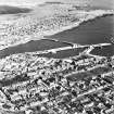
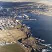
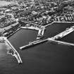
(Location cited as ND 368 505). Pultneytown Harbour. Built from 1824, first engineer Thomas Telford. The main harbour consists of two irregularly-shaped large basins, with a massive breakwater terminating in a lighthouse with a tapering octagonal tower. The other fixed light is on four cast-iron legs. At the extreme landward end of the inner basin is a boat slip. The harbour works are largely executed in mass concrete.
J R Hume 1977.
The Inner Harbour on the S (or Pultneytown) side of Wick Bay was built in 1808 by George Burn and reconstructed by Thomas Telford in 1824-31; it forms a roughly triangular basin.
J Gifford 1992.
Summary.
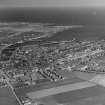
(Location of entrance to 1831 harbour cited as ND 370 506). Wick: the old part of the town of Wick stands on the left bank of the river of the same name, close to its mouth and well within its tidal range. Bishop Leslie, writing in the 1570's, describes Wick as the chief town of Caithness, but makes no mention of a harbour. Although the Bay of Wick is the first opening in the coastline to the S of Duncansby Head to receive the outfall of a river of any considerable size, harbour development has always been difficult. Shelter from the E is lacking, and it is from that quarter that some of the worst storms blow. Even today, no extensive area of the bay can be enclosed behind heavy protective works, because the seabed is of clay, in which foundations tend to shift. Sand from the sea and silt from the river choke the head of the bay, so that the better sheltered areas require constant dredging.
On Bishop Leslie's map, a long narrow inlet of the sea is shown in place of the stretch of river above the town, and this strikes inland along a line corresponding with the strip of the low-lying and particularly muddy ground that extends almost to Loch Watten. Shipping in the late 16th century used the town's waterfront, whether this was simply a beach or some kind of wharfage. In 1589 the Royal Burgh of Wick had a charter of King James VI, after Sutherland's men had plundered the possessions of a merchant, including his ships; at least one ship was seriously damaged. A Macfarlane document, dateable to the early 17th century, describes Wick as a safe harbour for ships to call at (oppidum, portu appelandis navibus tutum) while another mentions it as a harbour for the coasting trade in imports and exports. In 1654, however, the Crmwellian Commissioner Tucker reported no vessel belonging to Wick. By 1701, the description of Wick by the Rev John Brand shows that a revival had begun: 'Wick is a Royal Burgh, by the side of which runneth a small river, at the mouth of the River is a harbour for Boats or Barks to ly in, which they come in at full sea, but this harbour is not so much frequented as another [Staxigoe: ND35SE 65], about a Mile to the North East of Wick, where they judge the boats do ly safer.'
Sutherland relates this development to legislative changes beginning with the Act of 1661, the first to encourage the setting up of a company to establish fishing stations. Sutherland further relates harbour development at Wick to the associated change from the use of large ships, 'herring busses', to much smaller craft. Legislation provided in 1750 for a bounty on herring fishing boats of 20 to 80 tons, and in 1756 for the free use by fishermen of any suitable harbour or shore. Staxigoe [name: ND 384 524], the inlet N of Wick where Brand heard that ships could 'ly safer', adjoins the farm of Field, from where, in 1757, Alexander Miller with two partners fitted out two sloops on the bounty and began to fish, Wick having then no harbour 'only a rough quay', as most of the small trade it had was taken over the sandy shores of its river. Miller and his neighbours prospered. The first local station of the British Fisheries Society, incorporated in 1786, was at Staxigoe, the owners of smaller boats participating in greatly increasing numbers after 1785 when bounty was made payable on herring caught. Bounty was paid on 32 sloops in 1790 when 200 small boats worked out of Staxigoe, Wick and Broadhaven (ND35SE 101: ND 380 513), which is a rather less snug inlet between the two. Of the 230, 44 vessels wintered in the 'ship pool' at Wick. In 1793, J Rennie approved a plan, attributed in the Report of the Washington Commission on gale damage in 1849 to J Henderson, made a survey, and estimated for the British Fisheries Society that to build a harbour at Wick would cost £14,441 9s. Henderson had planned a harbour in the natural bend of the river [presumably at ND 363 508] to be excavated to the level of low water at spring tide, and to have a canal leading to it on the W (ie. the right bank) side of the estuary. By 1801, however, when the Society sent T Telford to acquire a harbour site, the 'natural harbour' site was required for the development of the Society's settlement, and the harbour was sited, perhaps more economically, in the NW corner of the bay.
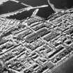
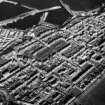
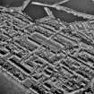
The first, inner or North harbour [ND35SE 66.08] was planned and laid out by Telford in 1803. The society obtained a grant of £7500 under the Fisheries Act of 1806, and the foundation stone was laid on 6 September in that year. The grant accrued from the work of the Commissioners for the Forfeited Estates. Half the initial cost of the harbour was in this way derived from one of the major operations which changed land ownership and management in the Highlands at this time and caused many people to seek work especially in coastal areas, including Wick. The harbour was not completed until 1811. Feus on the right bank of the river had been acquired from the estate of Hempbriggs, to which Alexander Miller was factor. Telford designed the new settlement for the fishing community, named Pulteney Town after the chairman of the society. The resident population of Lower Pulteney Town grew from 15 in 1790 to 2300 in 1830, and there was also a very large seasonal increase. Piped water, however, did not reach the harbour area until 1844. The resulting epidemic cholera merely checked further expansion periodically.
This expansion necessitated the provision of an outer harbour [ND35SE 66.09], planned in 1824, surveyed by Mitchell in 1825, partially destroyed by a storm while under construction by Bremner in 1827, and completed, together with modifications of the inner harbour, including the closing of its original entrance and the opening of another into the new harbour, in 1831. The Secretary to the British Fisheries Society gave 1834 as the date of final completion in his report. In 1842, Gibb, the Aberdeen engineer, was being consulted about sand accumulating in that harbour. The recommendation was than that Salmon Rock [name: ND 3719 5033], further out along the same shore of the bay, would be a suitable site for a steamer pier. A proposed harbour between Salmon Rock and the E pier of the outer harbour is marked on the 1839 Admiralty Survey plan, published by the Tidal Harbours Commissioners in 1847. Instead, the outer and inner harbours were deepened in 1847 and 1848. From then until the terminal date of this study (1850), the harbour facilities at Wick were continually overcrowded, and their deficiencies felt. In particular, the inadequacy of Wick as a harbour of refuge, with its narrow N-facing entrance at right-angles to the river mouth, led to the loss of 37 lives in sight of the harbour, in a storm in 1848. The Salmon Rock proposal was therefore reconsidered. In view of the failure of Stephenson's later massive breakwater, the society was probably right in rejecting the scheme on the advice of their Secretary and Law agents in 1848.
Small harbour works along the N shore of the bay are shown on the OS 1:2500 map of 1903, having grown in response to the overcrowding of the 1811 and 1831 harbours, Though none of the later 19th century attempts to render Wick safe as a harbour of refuge succeeded, its vast trade in herring declined only recently. A fortnightly steamer began to ply to Leith in 1833, and later a weekly one ran to Lerwick, Kirkwall, Aberdeen and again Leith. Sand in the harbour interrupted steamer services in 1860, no doubt with adverse effects on the traffic in freight, which in 1841 amounted to 30,000 tons.
Structure
The harbour area of Wick lies in a narrow cleft between the old town on the left [N] bank of the river a steep slope from the right [S] bank to the high ground from which upper Pulteneytown overlooks the estuary. The location of the 'ship-pool of Wick', in use in 1791, has not been identified. A plan of the town in Henderson's General View of the Agricultural of Caithness, printed in 1812, differs from the plan of 1789, referred to in the Washington Report, in many ways, including the lack of an exit, with piers and sluices, for the proposed canal. On a stretch of the river below the (A9) road bridge (Bridge of Wick: ND35SE 60) are the words ''vessels, lie in this part of the river.' It is not a pool, but above the bridge and the next bend in the river there is a wider stretch which might be so described. This is marked 'THE RIVER OF WICK' and was crossed by a timber bridge. An oil painting of this period shows boats beached on the left [N] bank where the river narrows, below an area still known as the Drying Green [not noted on OS 1:10,000 map, 1985].
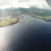
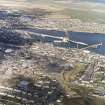
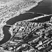
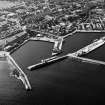
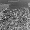
The layout of the harbours as completed in 1831 is little changed today, though largely covered in by modern surfacing. The entrance to the outer harbour [ND35SE 66.09] consists of an opening between the tip of a breakwater running out north-eastwards into the bay, and a pier, the N pier (ND35SE 66.02), which extends north-westwards along the edge of the tideway on the right-hand side of the estuary to join the river bank just below a bridge (ND35SE 69) which now spans the mouth. At the entrance of the 1831 harbour the breakwater pier originally extended well out into the tideway beyond the opening. A further extension was added in 1883. The 1831 harbour had originally a paved slope along its SW side, but a wharf was built over this before 1920. The present entrance to the inner (1811) harbour [ND 3691 5061] is an opening between its N pier and the E arm of the outer harbour. Slabs of grey stone, laid laterally, are visible from about half way along the inner face of the 1811 N pier to its E tip [around ND 3700 5055], which could be those laid in place by Bremner when he closed the original entrance and built the outer harbour. A slight change in the alignment of the N pier inner face before it reaches the opening of the outer harbour suggests that the original opening of the outer harbour may have been at about this point. Vertically-laid flagstones, which Bremner used in so much harbour construction, are still readily visible only on the outer face of the 1834 harbour's E breakwater pier.
The very recent construction of the N and S river piers [ND35SE 66.02 and ND35SE 66.03, respectively] and works along the left bank of the estuary have completely altered the river mouth, now a river basin, and the N shore frontage. A model of the estuary prior to these works is in the Wick Society's museum, and shows the names of some of the old small landing places, such as Reid's Harbour, and a projection called the Dicky.
A Graham and J Gordon 1988.
Build (1803 - 1811)
From 1790 both {Thomas] Telford and [John] Rennie produced plans and estimates for improving the harbour for the British Fisheries Society, but it was not until 1803 that the inner or north harbour was planned and laid out by Telford and completed in 1811.
R Paxton and J Shipway, 2007.
Build (1825 - 1831)
Expansion of the fishing industry required the provision of an outer harbour. This ‘New Harbour’ was planned in 1824, surveyed by Joseph Mitchell in 1825 and a contract awarded to James Bremner. Soon afterwards much of his partly completed work was destroyed in a storm. With consummate skill he saved the harbour from complete destruction in the teeth of the storm and eventually completed it in 1831 using the ingenious expedient of near vertically laid flagstones. Modifications were also made to the north harbour as part of this improvement.
R PAxton and J Shipway 2007
Publication Account (2007)
Wick Harbour and Pulteneytown
(Institute Civil Engineers Historic Engineering Works no. HEW 0599)
Harbour development at Wick has always been difficult because of a lack of shelter from the east. In the 18th century Wick had only a rough quay. From 1790 both Telford and Rennie produced plans and estimates for improving the harbour for the British Fisheries Society, but it was not until 1803 that the inner or north harbour was planned and laid out by Telford and completed in 1811.
Expansion of the fishing industry required the provision of an outer harbour. This ‘New Harbour’ was planned in 1824, surveyed by Joseph Mitchell in 1825 and a contract awarded to James Bremner. Soon afterwards much of his partly completed work was destroyed in a storm. With consummate skill he saved the harbour from complete destruction in the teeth of the storm and eventually completed it in 1831 using the ingenious expedient of near vertically laid flagstones. Modifications were also made to the north harbour as part of this improvement. Bremner’s vertical stone construction is still readily visible only on the outer face of the outer harbour.
For the Society Telford also planned the layout and designed numerous buildings in the new district of Pulteneytown [ND 3680 5080], named after Sir William Pulteney, adjoining the harbour to the south, in the early decades of the 19th century, of which Argyll Square survives as a fine testimonial to his planning and architectural skills.
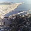
In 1861, in an attempt to protect the harbour from the effects of storms and to provide a larger haven, the British Fisheries Society obtained a report from D. & T. Stevenson which recommended the construction of a breakwater from each shore with a navigational channel opening between them. Work commenced in 1863 on the construction of a stone pier about 50 ft wide using narrow stone blocks weighing 5–10 tons set on edge resting on a
rubble mound the top of which was about 18 ft below low water.
By 1868 the southern breakwater had reached a length of about 1100 ft but, in 1870, one-third of its length was destroyed in a gale. An attempt was then made to secure the pier by means of blocks of concrete weighing from 80–100 tons each but this too failed. The upper structure was then rebuilt in Portland cement concrete but further serious damage ensued which was duly remedied. But, in 1877, the whole of the end of the breakwater, weighing
1350 tons, was carried away and the project abandoned to its fate after a total expenditure of £132 000. Its end with the inclined slabs can still be seen at the south shore. The problem, not then appreciated, was that when the breakwater encountered waves about 40 ft high, the rubble base beneath was susceptible to movement where it was less than about 40 ft below the surface. R. L. Stevenson, Thomas Stevenson’s son, who acted as resident inspector
in 1868, dubbed the project ‘the chief disaster of my father’s life’, but it did furnish an instructive example for engineers.
R Paxton and J Shipway, 2007.
Reproduced from 'Civil Engineering heritage: Scotland - Highlands and Islands' with kind permission from Thomas Telford Publishers.

