
Following the launch of trove.scot in February 2025 we are now planning the retiral of some of our webservices. Canmore will be switched off on 24th June 2025. Information about the closure can be found on the HES website: Retiral of HES web services | Historic Environment Scotland
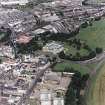
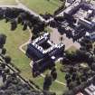
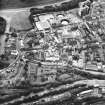
Edinburgh, Holyrood Road, Holyrood Brewery


Brewery (18th Century)
Site Name Edinburgh, Holyrood Road, Holyrood Brewery
Classification Brewery (18th Century)
Alternative Name(s) South Back Of Canongate; William Younger And Company; 112 Canongate; Milton House
Canmore ID 86530
Site Number NT27SE 588
NGR NT 26619 73777
NGR Description Centred NT26619 73777
Datum OSGB36 - NGR
Permalink http://canmore.org.uk/site/86530


- Council Edinburgh, City Of
- Parish Edinburgh (Edinburgh, City Of)
- Former Region Lothian
- Former District City Of Edinburgh
- Former County Midlothian
NT27SE 588 266 737
Includes information from cancelled site NT27SE 541
See also new Scottish Parliament Site No. NT27SE 4322
This brewery dates from the 18th and 19th centuries. A group of 1, 2 and 3-storey rubble buildings arranged around a courtyard with an L-plan 3-storey office block.
[see MS/744/68; DC27263-266; C91001-21/PO; C48553/9,10]
J R Hume 1976
NT 266 737 (centre). An evaluation was carried out on a number of derelict brewery sites between Canongate and Holyrood Road and S of Holyrood Road.
A sandstone quarry dated by artefacts to the 17th century was located in Wilson's Court, adjacent to Huntly House and Acheson House. Its limits could not be identified. It appeared to have had a relatively short life, but had a complex series of midden and other fills, probably complete by about the turn of the 17th and 18th centuries.
An 18th century cellar with a possible fireplace was identified in a gap site on the Canongate frontage adjacent to Acheson House (136 Canongate). Trenches in and behind a pend at 124 Canongate revealed natural silts directly underlying the modern surface, and demolition deposits not earlier than the 18th century.
Trenches in a large gap site between Royal Mile Promary School and Holyrood Road confirmed that most of this area had been truncated by terracing of the natural slope. A trench adjacent to Holyrood Road contained a deep accumulation of garden soils, deposited progressively from medieval times (possibly the 14th century) to the 17th century. A black deposit up to 3.5m deep waterlogged at its base, was present in the SW corner of this site. Identical black deposits (Probably part of the same episode) were recognised in trenches at 73 Holyrood Road and in a gap site opposite, on the S side of Holyrood Road; these formed a broad band at least 130m long from N to S. This material accumulated from late medieval to post-medieval times, but its origin is unknown.
A post-glacial loch occupied part of the area between Canongate and Salisbury Crags. A trench within this area revealed no evidence for any potential value for environmental studies, or for the survival of the loch as a body of water into historical times.
Sponsor: Lothian and Edinburgh Enterprise Limited.
D A Johnstone 1992.
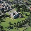
NT 267 738 An archaeological evaluation was undertaken jointly by Headland Archaeology and SUAT in advance of the redevelopment of the site as the new Scottish Parliament. Features of medieval date were restricted to an extensive backland soil, up to 1.4m in depth, together with a single drystone boundary wall. Early post-medieval activity was evident in the form of cultivation slots and structures relating to the formal gardens of Queensberry House. Tenement development dating to the 18th and 19th centuries was identified fronting onto Reids Close at the W edge of the site.
Sponsor: Historic Scotland
C Moloney 1998
NT 267 738 The excavation of a number of boreholes over the site of the New Parliament for Scotland site was monitored. The boreholes indicated the possible survival of early cultivation horizons, although post-medieval activity had resulted in the removal of earlier features over much of the site.
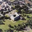
In the light of previous desk-based assessment and trial trenching, a trial trench was partially excavated in the gardens to the rear of Queensberry House (NT27SE 32.00) in April and May 1998. The archaeological potential of the site was suggested by documentary and cartographic evidence and the findings of a borehole survey sited a short distance to the S. The available evidence suggested the presence of deep stratified deposits reflecting primarily the evolution of the private formal gardens behind the 17th-century Queensberry House to the early 18th-century army parade ground, culminating in the present arrangement of flower beds, lawn and car parking serving the site's most recent role as a hospital (early 19th century to present).
The present threshold level for the S doorway at Queensberry House appears to be essentially unchanged since the construction of the mansion in the 17th century. However, the trial trenches showed clearly that a considerable degree of infilling over 17th-century garden levels has taken place. This in turn probably reflects the original terraced nature of the 17th-century layout, a consequence of the natural landfall down towards the line of Cowgate/Holyrood Road.
The broad chronology of the development of the garden area behind Queensberry House can be summarised as:
1. c 1679-1750 Formal, compartmentalised beds, probably on three steep and possibly graded terraces. The 17th-century and earlier deposits probably lie over 3m below ground level at the S end of the site and over 2m in the area of the trench.
2. c 1750-1785 Possible formal planting over infilled terraces, creating a large single garden plot. This appears to be the point at which the general ground level was raised significantly for the first time, creating a sloping profile for a large garden, rather than individual beds. This may in turn reflect the occupancy of the house by the Lord Chief Baron of Exchequer, James Montgomery of Stanhope.
3. c 1785-1808 Final formal layout for the garden, this time introducing formal divisions over the informal planting, creating a parterre arrangement. This was probably preceded by further landfill activity, bringing the general level of the garden up by losing the glacis or slope of the Period 2 layout.
4. c 1808-1832 After the sale of the house to the Board of Ordnance in 1803, the parterre garden was eventually cleared and converted to a parade ground.
5. c 1832-present The later history of the site is associated with the service and communal space behind the newly created People's Refuge and later Hospital. The layout as shown on the OS map of 1893 was succeeded by the present arrangement of parking bays around a central lawn, by the simple clearance of partition walls and the importation of new garden soils.
The majority of the deposits encountered are thought to be late 19th or 20th century in date although in some cases the majority of the finds were earlier than this. Given the degree of landfill from the late 18th century, this material is either imported or residual.
Sponsor: Historic Scotland
G Ewart 1998.
NT 267 738 An archaeological excavation was undertaken jointly by Headland Archaeology and SUAT in advance of the redevelopment of the site as the new Scottish Parliament. Five main phases of activity were identified.
Phase 1 Pre-burghal activity
Two features were identified pre-dating the formal division of the site into burgage plots, presumably in the 12th century. The first comprised a large ditch over 3m wide and 2m deep which ran along the boundary of the site parallel to Holyrood Road. Stratigraphically contemporary with this feature was a gravel track which ran diagonally across the site from SW-NE.
Phase 2 Medieval properties
The second phase of activity relates to the formal division of the site into burgage plots. These varied in width, but in general were approximately 10m wide in their earliest form but appear to have been sub-divided into 5m wide strips by the 15th-16th centuries. Typical backland features were found within these properties such as wells, rubbish pits and industrial features which were probably used for brewing and dying. The fragmentary remains of a number of stone buildings at the Canongate frontage suggest that stone was used for construction from the earliest times. The remains of the Canongate were also identified at least 1m wider than the present street on the S side.
Phase 3 Post-medieval cultivation
During the 16th century the site appears to have been given over to cultivation. An extensive sequence of cultivation slots was identified crossing the entire W side of the site. These may represent part of the formal gardens which developed with the grand residence which eventually became Queensberry House. A similar arrangement of cultivation slots was identified on the E side of the site (formerly the headquarters of Scottish and Newcastle) and these were probably associated with Lothian Hutt.
Phase 4 Formal gardens
The formal gardens of Queensberry House (built in the second half of the 17th century) were identified, laid out on two terraces with a wall revetting the upper terrace adjacent to the house and a set of splayed steps dropping down to the lower terrace. The boundary wall of the Queensberry property was also identified, as were a number of cultivation beds and tree pits associated with the formal garden. The neighbouring property to the W was also identified. This comprised a more modest dwelling identified as Haddington House, the town residence of the Earls of Haddington.
Phase 5 Military occupation (1808-32)
A number of buildings were added during the military occupation. In particular the quartermaster's block was particularly well preserved and was totally excavated. During this phase the terraced gardens of Queensberry House were levelled to form a parade ground.
Sponsor: Historic Scotland
C Moloney and R Coleman 1999
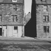
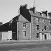
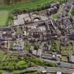
During May 1999, RCAHMS conducted a photographic survey of Holyrood Brewery at 93 Holyrood Road. The purpose of this survey was to enhance and augment the existing holdings of the National Monuments Record Scotland.
Visited by RCAHMS (MKO), May 1999
Boiler in Boiler House is oil or gas fired. Burner made by Hamworthy, Poole, England; Boiler made by Thompson Cochran, Annan, Scotland.
Oil-fired boiler -burner made by Laidlaw & Drew, Edinburgh; Boiler made by John Thompson, Lily Bank Works, Glasgow (1956).
Feed water pumps in Boiler House made by Weirs of Cathcart, and were formerly steam-powered, later electric.
Fuel oil heater and pump in Boiler House made by Laidlaw & Drew, Edinburgh.
Depth of water in Well -185 feet.
Excavation (April 1998 - May 1998)
NT 267 738 An archaeological evaluation was under taken jointly by Headland Archaeology and SUAT in advance of the redevelopment of the site as the new Scottish Parliament.
Features of medieval date were restricted to an extensive backland soil, up to 1.4m in depth, together with a single drystone boundary wall. Early post-medieval activity was evident in the form of cultivation slots and structures relating to the formal gardens of Queensberry House. Tenement development dating to the 18th and 19th centuries was identified fronting onto Reids Close at the W edge of the site.
C Moloney 1998
Sponsor: Historic Scotland
Headland, SUAT (Kirkdale Archaeology)
Note (10 May 1998)
This building was recorded as part of the TBS recording programme because it lies within the area proposed for the new Scottish Parliament building.
This housing development consists of two attached blocks. Built ar part of Holyrood Brewery
78 Canongate is also known as Vallence’s Entry. A four storeyed, four bayed block. The ground floor is faced in rubble while the upper floors are dry dash harled brick with a shallow jetty at first floor level. The roof is of asphalt. The ground floor contains storage and the bin store. The upper floors are reached via an open concrete stair which provides access to one, one bedroomed flat per floor.
80 Canongate is of identical construction. The block is three bayed and five storied.. The ground floor contains the pend of Reid’s Close and storage. Two bedroomed flats are located on the first, second and third floors and a covered drying green occupies the fourth floor. The upper floors are reached by an open concrete stair to the rear ,south, of the block.
78-80 Canongate was designed by Ian G Lindsay and Partners. The drawings are dated 14 January 1960. They were passed by the Dean of Guild Court on the 25 November 1960.
Photographic Survey (1999)
Photographic survey by RCAHMS in 1999 of the Holyrood Brewery, Edinburgh
Standing Building Recording (10 December 2011 - 12 June 2012)
NT 2657 7374 A programme of archaeological work was undertaken 10 December 2011 – 12 June 2012 prior to and during redevelopment of the site, and recorded six phases of activity. The earliest phase consisted of multiple layers of garden soils and a large well cut into the bedrock, possibly associated with medieval and post-medieval activity on the site. The remains of two walls, which may have related to a sugar refinery that occupied the site 1765–1850, represent the only upstanding features from Phase 2. A layer of pottery-rich loam recorded above the garden soils provided additional evidence of the sugar refinery. The pottery included large quantities of sugar cone and syrup jar fragments. Further excavation across the upper terrace of the site recorded various walls, floors, flues and culverts and discreet features associated with buildings linked to Phase 3 of the site. All these features were inside buildings first depicted in the 1852 OS map and seem to reflect industrial activity.
The standing building recording revealed that although the main fabric of the original brewery survived, much of the internal fixtures had been modified or completely removed. Four main phases (Phases 3–6) associated with the present buildings were identified. The first (Phase 3) saw the construction of the tenement located to the N side of the site. This was followed by the construction of the brewery (Phase 4) in 1868. A third phase (Phase 5) saw a reconstruction of the front entrance to the site in the 1940s along with a number of other superficial alterations. The final phase, commencing in the 1960s saw the demolition of a number of smaller buildings to the N of the main brewery complex and the subsequent construction a laboratory in the 1980s.
Archive: RCAHMS
Funder: Watkin-Jones Group
Donald Wilson, Headland Archaeology Ltd
2012

