
Dundee, East Dock Street, Dundee Gasworks


Gas Works (19th Century) - (20th Century)
Site Name Dundee, East Dock Street, Dundee Gasworks
Classification Gas Works (19th Century) - (20th Century)
Alternative Name(s) Peep O Day Lane; Melville Lane
Canmore ID 83745
Site Number NO43SW 136
NGR NO 41260 30760
Datum OSGB36 - NGR
Permalink http://canmore.org.uk/site/83745


- Council Dundee, City Of
- Parish Dundee (Dundee, City Of)
- Former Region Tayside
- Former District City Of Dundee
- Former County Angus
Publication Account (2013)
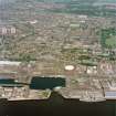
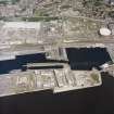
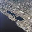
DUNDEE GASWORKS, North side of East Dock Street: The gasworks took made-up ground between what was the shore and the escarpment that
carries Broughty Ferry Road. This land was taken by some of the more noxious industries, and remains are fragmentary, e.g. the abattoir, which
once sported carved animals. The main gasworks has been cleared of most structures except one large postwar spiral-guided gas holder and some brick buildings with arched windows.
M Watson, 2013

