
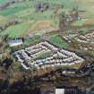
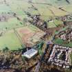
Wester Kittochside Farm


Building (18th Century)(Possible), Farmhouse (18th Century), Farmstead (19th Century), Museum (20th Century), Threshing Machine (Post Medieval)
Site Name Wester Kittochside Farm
Classification Building (18th Century)(Possible), Farmhouse (18th Century), Farmstead (19th Century), Museum (20th Century), Threshing Machine (Post Medieval)
Alternative Name(s) Museum Of Scottish Country Life; Kittochside
Canmore ID 83237
Site Number NS65NW 72
NGR NS 60832 56331
Datum OSGB36 - NGR
Permalink http://canmore.org.uk/site/83237


First 100 images shown. See the Collections panel (below) for a link to all digital images.
- Council South Lanarkshire
- Parish East Kilbride (South Lanarkshire)
- Former Region Strathclyde
- Former District East Kilbride
- Former County Lanarkshire
NS65NW 72 60832 56331
NS 6081 5636 Excavation was undertaken of an area around the in situ remains of an iron horse gin used for powering the threshing mill in the barn at Wester Kittochside Farm. The gin is positioned just to the NW of the barn, between it and a later structure, and was unenclosed. The gin was probably installed in the 1860s but had gone out of use by the 1890s.
An area 8m long SW-NE by 6.5m wide was excavated around the central wheel of the gin. This revealed a partially preserved cobbled surface, 5.5m in diameter and about 1m wide, around which the horses would have walked. The central iron-toothed wheel was c 1.35m in diameter and sat on a central spindle in a shallow, circular, stone-lined pit. This wheel pit was around 0.15m deep and had large flat stones along the base. The edge of the pit was also faced with stones. A small cog wheel was uncovered below the teeth of the main wheel on the SE side. This was attached to an iron drive shaft that was at least 3.7m long and ran into the barn to power the threshing machine. The gully along which the drive shaft ran was covered with a large sleeper beam (possibly a railway sleeper) and was built of two courses of brick on a base of slates. One brick was clearly marked with the name 'ADAM RUTHER'.
The iron drive shaft had been built in three lengths jointed at two collars and was held in place by an iron bracket. On removal of the soil from the base, and with a certain amount of persuasion by a blacksmith, the main wheel was able to turn. In due course the NMS hope to completely restore the gin and threshing mill to working order.
Archive to be deposited in the NMRS.
Sponsors: NTS, NMS.
D Alexander, M Miller 2003
NS 6083 5633 A ground resistance survey of four 20 x 20m squares was made in the area surrounding Wester Kittochside Farm. Three of the squares were to the front of the 1780s farmhouse, one to the S and two to the W, and one square was to the N of the farm buildings. No features were found in the area immediately to the S of the farmhouse (approx one 20m square), and of the two squares to the W of the farmhouse, the two high resistance anomalies were considered to be associated with the underlying geology. The resistance readings for the square to the N of the farm buildings were also affected by the proximity of the volcanic rock on which the farm was built. However, one high resistance area, approximately 7m square, in front of the Dutch Barn, might indicate the presence of a former building.
Sponsors: NMS, NTS, Edinburgh Archaeological Field Society.
ACM Calder, 2006.
NS65NW 72 6083 5634
Wester Kittochside Farm was in full use as a dairy farm until the early 1970s. There is a surviving example of a roller feed, horse driven fixed barn mill with external open horse engine. It was last used in the 1920s. The maker was McCartney and Drummond of Cumnock, Ayrshire. For a full description of the threshing machine and for a farm building outlay, see NMRS MS 744/165
Visited by RCAHMS (GJD) September 1986.
NMRS MS 744/165.
Geophysical Survey (2006)
NS 6083 5633 A ground resistance survey of four 20 x 20m squares was made in the area surrounding Wester Kittochside Farm. Three of the squares were to the front of the 1780s farmhouse, one to the S and two to the W, and one square was to the N of the farm buildings. No features were found in the area immediately to the S of the farmhouse (approx one 20m square), and of the two squares to the W of the farmhouse, the two high resistance anomalies were considered to be associated with the underlying geology. The resistance readings for the square to the N of the farm buildings were also affected by the proximity of the volcanic rock on which the farm was built. However, one high resistance area, approximately 7m square, in front of the Dutch Barn, might indicate the presence of a former building.
Sponsors: NMS, NTS, Edinburgh Archaeological Field Society.
A C M Calder 2006

