
Greenside, Steading


Farmstead (19th Century)
Site Name Greenside, Steading
Classification Farmstead (19th Century)
Canmore ID 80929
Site Number NO30NE 26
NGR NO 39314 07354
Datum OSGB36 - NGR
Permalink http://canmore.org.uk/site/80929


- Council Fife
- Parish Ceres
- Former Region Fife
- Former District North East Fife
- Former County Fife
NO30NE 26 39314 07354.
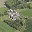
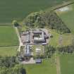
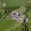
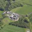
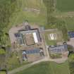
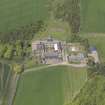
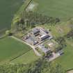
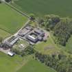
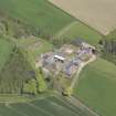
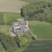
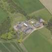
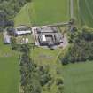
This very unusual U-shaped steading of about 1845 is partly built into the slope of the land and has late-nineteenth-century additions. These include a sunken covered cattle court with a slate roof carried on laminated wooden roof trusses (see MS/744/22/1-5).
The OS maps of 1854 (1st edition, 6-inch map, Fife, sheet XVIII), 1893 (2nd edition, 25-inch map, Fife, sheet XXI.1), 1912 (2nd edition revision, 25-inch map, Fife, sheet XXI.1) and 1964 (1:2500) show the development of the steading. The 1st edition OS map (1854) does not show the sunken cattle court, a roof over the S cattle court or the row of workers' houses.
The ONB entry (1854) states that "...the steading is of recent construction and in good repair..." and that it was the property of William Rofs Esquire.
Visited by RCAHMS (GJD & HLG) January, March 1990.
This U-plan steading with a detached fourth side is occupied by a workshop, store and henhouse There is also a steam-powered threshing barn. The courtyard contains a roofed, sunken cattle court, with a second covered court below the detached front range. The steading was disused but in fair order on the date of survey.
RCAHMS and NMS, 1998a.

