
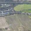
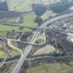
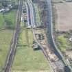
Antonine Wall: Dullatur - Castlecary


Defensive Pits (Roman), Frontier Defence (Roman)
Site Name Antonine Wall: Dullatur - Castlecary
Classification Defensive Pits (Roman), Frontier Defence (Roman)
Canmore ID 74532
Site Number NS77NE 62
NGR NS 77255 77828
NGR Description From NS 7500 7720 to NS 8000 7875
Datum OSGB36 - NGR
Permalink http://canmore.org.uk/site/74532


- Council North Lanarkshire
- Parish Cumbernauld
- Former Region Strathclyde
- Former District Cumbernauld And Kilsyth
- Former County Dunbartonshire
NS77NE 62.00 7500 7720 to 8000 7875
NS77NE 62.01 NS 757 773 Antonine Wall, Mainhead Antonine Wall; Field Survey Area; Trial Excavation
NS77NE 62.02 from NS 7500 7719 to NS 8000 7875 Antonine Wall, Military Way
RRX505 7785 7790 to 7854 7813.
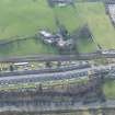
RRX505 756 773 to 764 774 - Westerwood
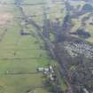
RRX505 779 777 - 783 781 - Garnhall
RRX505 768 776 - 778 779 - Wardpark
RRX 505 793 785 - 796 786 - Dundas Cottages
NS 7500 7723 to NS 7515 7726 Published course (OS 25 inch 1958) revised. No trace; destroyed by railway embankment. A slight alignment change can be expected at in the area of NS 7515 7726, (the highest point before the descent to Dullatur) in order to meet the extant straight further W.
NS 7517 7726 to NS 7600 7741 Published survey (OS 25 inch 1958) revised. The Ditch is progressively well defined from E to W, averaging 11m to 14m wide and from 1.5m deep on the E to over 3m deep on the W. A slight alignment angle can be determined at NS 755 773. There are no extant remains of the Rampart, and only occasional indications of the Outer Mound. Under Scottish Development Department (Inspectorate of Ancient Monuments) Guardianship from NS 7565 7733 westwards.
NS 7600 7741 to NS 7650 7751 Published survey (OS 25 inch 1972) revised. The Ditch, up to 2.5m deep and c.14m wide, is reasonably well defined though mutilated in places. No surface remains of Rampart or Outer Mound.
NS 7606 7741 Pipe trenches cut in c.1978 revealed sections of Rampart, Ditch and Outer Mound. (see NS77NE 8) (L J F Keppie and D J Breeze 1982).
NS 7650 7751 to NS 7679 7763 Published course (OS 50 inch 1967) resurveyed. There are scant remains of the Ditch, up to 1m deep, that confirm the exact course as clearly shown on the 2nd edition of the OS 2 and a half inch map (Stirlingshire 1898, sheet 29/10). No trace of Outer Mound, but a spread of remnant of the Rampart is visible on the S side of the derelict Arniebog Cottage at NS 7650 7751.
NS 7679 7763 to NS 7700 7776 Published survey (OS 50 inch 1967) revised. The Ditch is fairly well preserved, c.12m to c.14m wide and up to 3m deep. No trace of Rampart. The Outer Mound is largely extant, up to 2m high. Under Scottish Development Department (Inspectorate of Ancient Monuments) Guardianship from sheet edge to NS 7690 7769.
NS 7700 7776 to NS 7750 7787 Published survey (OS 50 inch 1967) revised. The Ditch, though spread, is fairly well defined and up to 16m wide and 2.5m deep. No trace of Rampart. The Outer Mound is prominent, c.15m wide and 1.2m high. Under Scottish Development Department (Inspectorate of Ancient Monuments) Guardianship.
NS 7702 7775 Several sections were cut across the Rampart in 1979, and a stone built platform revealed. (see NS77NE 28) (L J F Keppie and D J Breeze 1982).
NS 7705 7774 Several sections were cut across the Rampart and Military Way in c.1964 (L J F Keppie and D J Breeze 1982).
NS 7714 7779 Large freestones were found c.1851 on the S side of the Ditch (ONB 1861).
NS 7750 7787 to NS 7800 7796 Published survey (OS 50 inch 1970) revised. The Ditch, though much spread, is fairly well-defined and up to about 24m wide and 2.5m deep. No trace of Rampart. The Outer Mound is extent in the W half of this sector. Under Scottish Development Department (Inspectorate of Ancient Monuments) Guardianship.
NS 7800 7796 to NS 7809 7800 Published course (OS 25 inch 1969) resurveyed. The Ditch, only, survives and although spread, is still well-defined, being about 20m wide and up to 2m deep. Under Scottish Development Department (Inspectorate of Ancient Monuments) Guardianship.
NS 7809 7800 to NS 7834 7815 Published course (OS 25 inch 1970) resurveyed from remains of Ditch, spread to an average width of some 20m and depth up to 2m. No trace of Wall (or 1977 excavations); the Outer Mound is confused by a trackway, and is truncated by a hedgerow W of the ruins of Garnhall. Under Scottish Development Department (Inspectorate of Ancient Monuments) Guardianship.
NS 7822 7815 Excavations in 1977 exposed areas of the Wall base, defined the edges of the Ditch, and located possible traces of the Military Way (L J F Keppie and H B Millar 1977; L J F Keppie and D J Breeze 1982).
NS 7834 7815 to NS 7877 7820 Published course (OS 25 inch 1970) resurveyed. No traces through developed area apart from a c. 12m length overgrown and denuded Ditch c. 13m wide and 1.2m deep (N side) at NS 7862 7824. The exact course of the Ditch is well defined on the 1st edition of the OS 2 and a half inch (Stirlingshire 1860, sheet 29/10) which shows a distinctive flattened bend at NS 7850 7826. This may be a convenience to lessen the otherwise sharp dog-leg required because the bend in the ridge-line, or it could indicate an unknown feature on the Wall at this point. The new line utilizes Macdonald's conclusions and the clear indication of the 1st edition of the OS 2 and a half inch map.
NS 7838 7815 Wall base excavated in 1931 (G Macdonald 1934).
NS 7855 7845 Watching brief during redevelopment of former brickworks about 1977 proved negative (L J F Keppie and D J Breeze 1982).
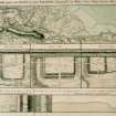
NS 7877 7821 Ditch crosses Red Burn just S of old bridge (W Maitland 1757).
NS 7877 7820 to NS 7900 7835 Published course (OS 25 inch 1970) resurveyed. No traces across developed area, although there is significant subsidence cracking at Castra Cottage. The new line is based on re-examination of excavated plans NS 7884 7827 and NS 7888 7829 and the projected line of these results. It is assumed that the c. 5m width of the Ditch across difficult ground was constant as far as Red Burn.
NS 7884 7827 Course and width of Ditch found by excavation in 1902. Re-excavation in 1930-1 inconclusive after disturbances (G Macdonald 1934; D Christison 1902-3; M Buchanan 1902-3).
NS 7888 7829 to NS 7904 7835 Position and form of Ditch on N side of Castlecary fort determined by excavation. Excavation proved the line of Rampart and Ditch. Military Way was found to run south of and parallel to the modern road. (see NS77NE 24) (D Christison 1902-3; M Buchanan 1902-3).
NS 7900 7835 to NS 7906 7838 The Ditch is barely perceptible through school (now a private house) grounds. Distinctive profile against east wall. The line is extant on 1st edition of the OS 2 and a half inch (Stirlingshire 1860, sheet 29/7).
NS 7906 7838 to NS 7966 7864 Published course (OS 25 inch 1970) revised. The Ditch only, is evident as a severely ploughed down hollow up to 1.3m deep. The line is extant on 1st edition of the OS 2 and a half inch (Stirlingshire 1860, sheet 29/7). Under Scottish Development Department (Inspectorate of Ancient Monuments) Guardianship W of NS 7921 7843.
NS 791 783 Excavations to underpin the foundations of a house that had cracked at both east and west gables and was settling along its entire south frontage revealed the forward slope of the Antonine ditch at a depth of 1.2m below the present surface under the gable cracks and sloping to a depth of 3m below the front wall. In the section to the rear or north of the gable cracks an old turf line was observed at an average depth of 1.2m with an upcast over this to a maximum height of 3.5m. A fragment of antler some 125mm long with two well eroded points was recovered from the ditch surface under the south east corner of the house (J S Wood 1982).
NS 7966 7864 to NS 7987 7870 No surface trace; destroyed by development. The line is extant on 1st edition of the OS 2 and a half inch (Stirlingshire 1860, sheet 29/7).
NS 7987 7870 to NS 8000 7875 Published survey (OS 25 inch 1970) revised. The Ditch, c.16m wide and 1m to 2m deep, and Outer Mound, up to 1m high, are both denuded but reasonably well delineated. No trace of Rampart. The line is extant on 1st edition of the OS 2 and a half inch (Stirlingshire 1860, sheet 29/7).
Information from OS 1980
D Christison 1902-3; M Buchanan 1902-3; L J F Keppie and H B Millar 1977; L J F Keppie and D J Breeze 1982; G Macdonald 1934; W Maitland 1757; ONB 1861; J S Wood 1982
NS 770 777 (See also NS77NE 28) Excavation to locate a 'watch-tower' recorded in 1872 proved unsuccessful, but the line of the Wall was checked for a distance of 90m. Up to six layers of turf were visible above the stonework. Lengths of cobbling 0.6m S of the stone base and a stone dyke two courses high, overlying fallen turf, represent repairs to prevent slippage. A platform had been added to the S kerb of the Wall foundation. It was one stone thick and measured 12m E-W by 18m, with wing-walls, one at least 4.5m long, projecting from its southern corners. It showed considerable signs of burning and seems not to have supported a turf stack. A trench was dug to the south, to establish whether it lay within a ditched enclosure of the type observed near Balmuildy (NS57SE 19), but no such ditch was found.
F O Grew 1980.
NS 791 783 Excavation to underpin cracks in a house ('Castra') revealed the forward face of the Antonine ditch sloping to a depth of 3m.
J S Wood 1982; S S Frere 1983.
ALLANDALE, DUNDAS COTTAGES - Antonine Wall.
NS 793 783 A stretch of 17m of the stone base of the Antonine Wall was cleared, prior to housebuilding. The base proved to have been considerably damaged over the years, especially by two sewer pipes running along its length. Both kerbs had been robbed away. The base was crossed by a culvert, of which four capstones remained in situ. The turf superstructure survived to a height of 0.25m. Some 50 fragments of Roman pottery, from at least three vessels in Black-burnished I fabric, were recovered. The S edge of the Antonine ditch was located at a distance of c.6.5m from the base. Wall and ditch lay on the alignment shown on current OS maps. A bungalow now stands on the site.
L J F Keppie and J J Walker 1985.
NS 7939 7855 Two test pits were excavated on a raised footpath within the Scheduled area of the Antonine Wall, prior to the proposed insertion of a foul water sewer. Excavation to a depth of 1m failed to progress beyond made-ground deposits, and no significant archaeological features or artefacts were located.
Sponsor: McGregor, McMahon & Associates.
J Gooder 2000
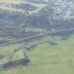
WESTERWOOD.
The construction of a golf course complex north of Cumbernauld has resulted in the landscaping of wide areas around Westerwood Roman Fort. A corridor comprising the upcast mound, Antonine Wall and Military Way will be left untouched. In December 1986 its N and S limits were determined by excavation. In April 1987 a sample area immediately W of the fort and S of the Military Way was selected for detailed inspection. Some spreads of cobbling and a sequence of stone lined pits may be linked to an agricultural establishment in the period 1450-1600. However, for the most part, ploughing in late medieval and more modern times had removed earlier features. A U-shaped ditch whose fill yielded Roman material ran NS across the site. Other shallow channels could be remnants of a Roman field system. A possible roadway was detected leading S from the fort's S gate. The line of the Antonine Wall and Military Way was also checked in advance of intended pipelaying. The stone base proved to be excellently preserved, at a depth of 0.23m. It was 4.3m wide. The Military Way had been totally removed at this point. Because of the fine state of the Wall base, the pipeline was eventually laid further W, close to a stream bed. The stone base (here somewhat disturbed), the ditch and upcast were again observed in section.
L Keppie 1987.
A trench across the Upcast Mound c.75m W of the NW corner of the fort showed it to be 21.6m wide and to be composed of successive tips of buff clay, broken stone and bluish-grey clay, possibly in order of excavation from the ditch.
S S Frere 1987.
An attempt was made to establish the alignment and purpose of the U-shaped ditch noted in 1987. The ditch seemed then to be heading N towards the Military Way. Excavation in 1988 failed to confirm its alignment, but served to establish the line of the Military Way itself more precisely. Numerous small finds, of Antonine date, included fragments of a face-mask jar and a colander. This material seemed to have been dumped and levelled perhaps as a foundation for hard-standing W of the fort.
L Keppie and J Walker 1988.
CASTLECARY
Excavations to underpin Castra Cottage, which had cracked at both E and W gables and was settling along its entire frontage, revealed the forward slope of the Antonine ditch at a depth of 1.2m below the present surface under the cracks and sloping to a depth of 3m below the front wall.
L J F Keppie and J J Walker 1990
GARNHALL
NS 782 780 Well-preserved stretches of rampart and ditch were exposed. The Wall base was 4.3m wide, with some turf-work above. At one point the junction between two working parties was noted. At another point was evidence of repairs to the S kerb. The ditch was 12.3m - 12.7m wide, both lips marked by edging-stones. The berm was 7.5m wide. The ditch upcast formed a direct continuation of the N face of the ditch. Sections were cut across the presumed line of the Military Way.
L J F Keppie and H B Millar 1977; R Goodburn 1978
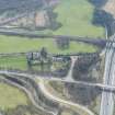
NS 780 779 Excavations were carried out between the forts of Castlecary and Westerwood and its importance lies in it being the only point on the Wall line able to see both forts simultaneously, from the height of a Roman tower. The excavations fall into two sections: the W area to study the circular feature, possibly a Roman tower, and an eastern area to look at anomalies detected during resistivity and probing surveys and to check on the exact course of the Wall. The Wall base was found close to its expected line. Only slight traces of turf work survived, but the southern side of the stone base was well preserved with a stone drain. Plough damage was progressively worse as the Ditch was approached whereas in some sections the northern part of the base had vanished altogether.
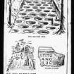
A series of three sub rectangular pits were found on the berm. These were c.1m E-W by 50cm N-S by 15cm - 20cm deep and were separated by c.45cm gaps. They ran in a line parallel to the Wall base, c.1.5m north of the projected line of the north kerb of the [wall base]. Two of the pits had well preserved stake holes in their bottoms, with one pit also being stone packed. These may well represent the Roman pit traps known as "Lilia", groups of which had already been found on the Antonine Wall at Rough Castle (NS87NW 6) and Callendar Park (NS97NW 46.01). Extensive plough damage may explain why only a single row of pits was discovered rather than the usual chequer board pattern.
Two trenches confirmed the position of the ring ditch seen in the aerial photograph. It was found to consist of a re-cut "V" shaped ditch of standard Roman military type, c.1m deep and 2.3m wide. This ditch surrounds an interior area of c.14m in diameter making the structure as a whole remarkably similar to the Roman towers on the Gask Ridge (Westerton) (NN81SE 7). A third trench in the interior revealed a closely grouped series of three postholes which may represent the south-east corner of a Roman timber tower which has been subject to several re-buildings.
D J Woolliscroft 1993
Excavation of part of the wall at NS 780 779 revealed the stone base, crossed by a culvert, with a spread of cobbling to the S. On the berm was an E-W alignment of three rectangular pits, 1m by 0.5m and 0.15-0.2m deep; in the bottoms of two of the pits were stake holes, 3cm-4cm in diameter.
L J F Keppie 1993
NS 780 779 Continued investigation of the ring-ditch enclosure (NS77NE 30) S of the Antonine Wall. The adjacent W defensive ditch of Garnhall 2 marching-camp (NS77NE 30) was also examined, at the point where it appeared from aerial survey to run below the Wall itself. However, excavation revealed that the camp ditch terminated in a butt-end 1m S of the Wall, and so may define an enclosure lying entirely S of it. Immediately E of the camp-ditch, and predating it, was a stone platform attached to the S kerb of the Wall which here incorporated an intact culvert, with turfwork surviving to a height of 0.26m (for a similar platform at Tollpark (NS77NE 62.00: NS 770 777) (Keppie and Breeze 1982).
L J F Keppie 1995; L J F Keppie and D J Breeze 1982.
NS 7610 7743 A series of excavations and watching briefs took place at Westerwood fort (NS77NE 8), Antonine Wall and the Military Way between 1985-87 in order to develop the Westerwood Golf Course. The line of the Antonine Wall, Ditch, upcast Mound and Military Way was established. Surface traces of the upcast mound N of the Antonine Ditch suggest a 26m wide embankment. In 1986 a single trench was cut across the mound c.75m W of the NW corner of the fort. The upcast proved to extend northwards for 2.16m from the likely position of the N lip of the Antonine Ditch.
Two trenches were cut in 1987 c.100m W of the fort, in advance of a pipe-trench, across the Military Way and stone-base of the Antonine Wall. The stone base was located in good preservation at a depth of 0.23m below the present day grassy surface. The base was 4.38m wide, made of large sandstone cobbles. Its position and alignment conform to OS maps. The superstructure was of turf, of which two courses were visible above the base, to a height of 0.3m. The ditch was not explored.
Sponsor: Historic Scotland
L J F Keppie 1996
NS 780 779 Further small-scale work identified the last of the four post-holes supporting a square tower, and clarified the alignment of a metalled track linking it to the Military Way.
L J F Keppie 1996.
Antiquarian Observation (1757)
NS 7877 7821 Ditch crosses Red Burn just S of old bridge (W Maitland 1757).
Antiquarian Observation (1851)
NS 7714 7779 Large freestones were found c.1851 on the S side of the Ditch (ONB 1861).
Excavation (1872)
NS 770 777 (See also NS77NE 28) Excavation to locate a 'watch-tower' recorded in 1872 proved unsuccessful, but the line of the Wall was checked for a distance of 90m.
Excavation (March 1902 - November 1902)
NS 7888 7829 to NS 7904 7835 Position and form of Ditch on N side of Castlecary fort determined by excavation. Excavation proved the line of Rampart and Ditch. Military Way was found to run south of and parallel to the modern road. (see NS77NE 24) (D Christison 1902-3; M Buchanan 1902-3).
Excavation (March 1902 - November 1902)
NS 7884 7827 Course and width of Ditch found by excavation in 1902. Re-excavation in 1930-1 inconclusive after disturbances (G Macdonald 1934; D Christison 1902-3; M Buchanan 1902-3).
Excavation (1930 - 1931)
NS 7884 7827 Course and width of Ditch found by excavation in 1902. Re-excavation in 1930-1 inconclusive after disturbances (G Macdonald 1934; D Christison 1902-3; M Buchanan 1902-3).
Aerial Photography (29 July 1945)
Aerial Photography (1 August 1946)
Aerial Photography (7 July 1948)
Aerial Photography (6 July 1949)
Aerial Photography (6 July 1949)
Aerial Photography (11 July 1951)
Aerial Photography (12 July 1952)
Aerial Photography (22 July 1952)
Aerial Photography (14 July 1955)
Aerial Photography (2 August 1956)
Aerial Photography (2 August 1956)
Aerial Photography (1 August 1957)
Aerial Photography (16 July 1958)
Aerial Photography (14 July 1959)
Trial Trench (1959 - 1980)
NS 770 777 Sections were taken across the presumed line of the Military Way and Rampart. Turfwork found on Rampart (MacIvor, I.).
Aerial Photography (17 July 1961)
Aerial Photography (27 July 1963)
Publication Account (1963)
NS 760 770 Ministry of Public Buildings and Works, Antonine Wall Base 14' 6" wide (MOPBW 1964).
Excavation (1964)
NS 7705 7774 Several sections were cut across the Rampart and Military Way in c.1964 (L J F Keppie and D J Breeze 1982).
Aerial Photography (2 August 1966)
Aerial Photography (28 July 1966)
Aerial Photography (28 July 1967)
Aerial Photography (27 July 1968)
Aerial Photography (1971)
Aerial Photography (26 July 1972)
Observation (1974)
NS 7700 7700 Base of stone Rampart measures 14ft 6in wide. Seen in stream bed (Information from D.J.Breeze to L.J.F.Keppie)(Tollpark).
Aerial Photography (3 August 1977)
Aerial Photography (21 July 1977)
Aerial Photography (30 July 1977)
Watching Brief (1977)
NS 7855 7845 Watching brief during redevelopment of former brickworks about 1977 proved negative (L J F Keppie and D J Breeze 1982).
Excavation (1977)
NS 782 780 Well-preserved stretches of rampart and ditch were exposed. The Wall base was 4.3m wide, with some turf-work above. At one point the junction between two working parties was noted. At another point was evidence of repairs to the S kerb. The ditch was 12.3m - 12.7m wide, both lips marked by edging-stones. The berm was 7.5m wide. The ditch upcast formed a direct continuation of the N face of the ditch. Sections were cut across the presumed line of the Military Way.
L J F Keppie and H B Millar 1977; R Goodburn 1978
Excavation (1977)
NS 7822 7815 Excavations in 1977 exposed areas of the Wall base, defined the edges of the Ditch, and located possible traces of the Military Way (L J F Keppie and H B Millar 1977; L J F Keppie and D J Breeze 1982).
Salvage Record (1978)
NS 7606 7741 Pipe trenches cut in c.1978 revealed sections of Rampart, Ditch and Outer Mound. (see NS77NE 8) (L J F Keppie and D J Breeze 1982).
Excavation (1979)
NS 7702 7775 Several sections were cut across the Rampart in 1979, and a stone built platform revealed. (see NS77NE 28) (L J F Keppie and D J Breeze 1982).
Excavation (1979)
NS 770 777 (See also NS77NE 28) Excavation to locate a 'watch-tower' recorded in 1872 proved unsuccessful, but the line of the Wall was checked for a distance of 90m. Up to six layers of turf were visible above the stonework. Lengths of cobbling 0.6m S of the stone base and a stone dyke two courses high, overlying fallen turf, represent repairs to prevent slippage. A platform had been added to the S kerb of the Wall foundation. It was one stone thick and measured 12m E-W by 18m, with wing-walls, one at least 4.5m long, projecting from its southern corners. It showed considerable signs of burning and seems not to have supported a turf stack. A trench was dug to the south, to establish whether it lay within a ditched enclosure of the type observed near Balmuildy (NS57SE 19), but no such ditch was found.
F O Grew 1980.
Field Visit (1980)
NS 7900 7835 to NS 7906 7838 The Ditch is barely perceptible through school (now a private house) grounds. Distinctive profile against east wall. The line is extant on 1st edition of the OS 2 and a half inch (Stirlingshire 1860, sheet 29/7).
Field Visit (1980)
NS 7500 7723 to NS 7515 7726 Published course (OS 25 inch 1958) revised. No trace; destroyed by railway embankment. A slight alignment change can be expected at in the area of NS 7515 7726, (the highest point before the descent to Dullatur) in order to meet the extant straight further W.
Information from OS 1980
Field Visit (1980)
NS 7600 7741 to NS 7650 7751 Published survey (OS 25 inch 1972) revised. The Ditch, up to 2.5m deep and c.14m wide, is reasonably well defined though mutilated in places. No surface remains of Rampart or Outer Mound.
Information from OS 1980
Field Visit (1980)
NS 7517 7726 to NS 7600 7741 Published survey (OS 25 inch 1958) revised. The Ditch is progressively well defined from E to W, averaging 11m to 14m wide and from 1.5m deep on the E to over 3m deep on the W. A slight alignment angle can be determined at NS 755 773. There are no extant remains of the Rampart, and only occasional indications of the Outer Mound.
Information from OS 1980
Field Visit (1980)
NS 7650 7751 to NS 7679 7763 Published course (OS 50 inch 1967) resurveyed. There are scant remains of the Ditch, up to 1m deep, that confirm the exact course as clearly shown on the 2nd edition of the OS 2 and a half inch map (Stirlingshire 1898, sheet 29/10). No trace of Outer Mound, but a spread of remnant of the Rampart is visible on the S side of the derelict Arniebog Cottage at NS 7650 7751.
Information from OS 1980
Field Visit (1980)
NS 7700 7776 to NS 7750 7787 Published survey (OS 50 inch 1967) revised. The Ditch, though spread, is fairly well defined and up to 16m wide and 2.5m deep. No trace of Rampart. The Outer Mound is prominent, c.15m wide and 1.2m high.
Information from OS 1980
Field Visit (1980)
NS 7750 7787 to NS 7800 7796 Published survey (OS 50 inch 1970) revised. The Ditch, though much spread, is fairly well-defined and up to about 24m wide and 2.5m deep. No trace of Rampart. The Outer Mound is extent in the W half of this sector.
Information from OS 1980
Field Visit (1980)
NS 7679 7763 to NS 7700 7776 Published survey (OS 50 inch 1967) revised. The Ditch is fairly well preserved, c.12m to c.14m wide and up to 3m deep. No trace of Rampart. The Outer Mound is largely extant, up to 2m high.
Information from OS 1980
Field Visit (1980)
NS 7800 7796 to NS 7809 7800 Published course (OS 25 inch 1969) resurveyed. The Ditch, only, survives and although spread, is still well-defined, being about 20m wide and up to 2m deep.
Information from OS 1980
Field Visit (1980)
NS 7809 7800 to NS 7834 7815 Published course (OS 25 inch 1970) resurveyed from remains of Ditch, spread to an average width of some 20m and depth up to 2m. No trace of Wall (or 1977 excavations); the Outer Mound is confused by a trackway, and is truncated by a hedgerow W of the ruins of Garnhall.
Information from OS 1980
Field Visit (1980)
NS 7834 7815 to NS 7877 7820 Published course (OS 25 inch 1970) resurveyed. No traces through developed area apart from a c. 12m length overgrown and denuded Ditch c. 13m wide and 1.2m deep (N side) at NS 7862 7824. The exact course of the Ditch is well defined on the 1st edition of the OS 2 and a half inch (Stirlingshire 1860, sheet 29/10) which shows a distinctive flattened bend at NS 7850 7826. This may be a convenience to lessen the otherwise sharp dog-leg required because the bend in the ridge-line, or it could indicate an unknown feature on the Wall at this point. The new line utilizes Macdonald's conclusions and the clear indication of the 1st edition of the OS 2 and a half inch map.
Information from OS 1980
Field Visit (1980)
NS 7877 7820 to NS 7900 7835 Published course (OS 25 inch 1970) resurveyed. No traces across developed area, although there is significant subsidence cracking at Castra Cottage. The new line is based on re-examination of excavated plans NS 7884 7827 and NS 7888 7829 and the projected line of these results. It is assumed that the c. 5m width of the Ditch across difficult ground was constant as far as Red Burn.
Information from OS 1980
Field Visit (1980)
NS 7906 7838 to NS 7966 7864 Published course (OS 25 inch 1970) revised. The Ditch only, is evident as a severely ploughed down hollow up to 1.3m deep. The line is extant on 1st edition of the OS 2 and a half inch (Stirlingshire 1860, sheet 29/7).
Information from OS 1980
Field Visit (1980)
NS 7966 7864 to NS 7987 7870 No surface trace; destroyed by development. The line is extant on 1st edition of the OS 2 and a half inch (Stirlingshire 1860, sheet 29/7).
Field Visit (1980)
NS 7987 7870 to NS 8000 7875 Published survey (OS 25 inch 1970) revised. The Ditch, c.16m wide and 1m to 2m deep, and Outer Mound, up to 1m high, are both denuded but reasonably well delineated. No trace of Rampart. The line is extant on 1st edition of the OS 2 and a half inch (Stirlingshire 1860, sheet 29/7).
Information from OS 1980
Excavation (1982)
NS 791 783 Excavations to underpin the foundations of a house that had cracked at both east and west gables and was settling along its entire south frontage revealed the forward slope of the Antonine ditch at a depth of 1.2m below the present surface under the gable cracks and sloping to a depth of 3m below the front wall. In the section to the rear or north of the gable cracks an old turf line was observed at an average depth of 1.2m with an upcast over this to a maximum height of 3.5m. A fragment of antler some 125mm long with two well eroded points was recovered from the ditch surface under the south east corner of the house (J S Wood 1982).
NS 791 783 Excavation to underpin cracks in a house ('Castra') revealed the forward face of the Antonine ditch sloping to a depth of 3m.
J S Wood 1982; S S Frere 1983.
Augering Survey (1983)
NS 772 778 The continuing search for a Roman fortlet at Tollpark revealed the S kerb of the Wall, with further evidence of repair, and a stone-filled hollow running away to the S.
L F J Keppie and J J Walker 1982
A raised plateau immediately to the E of the area explored in 1979 was investigated in 1982-3 but without positive result.
L J F Keppie and J J Walker 1990
Salvage Record (April 1985)
NS 793 783 A stretch of 17m of the stone base of the Antonine Wall was cleared, prior to housebuilding. The base proved to have been considerably damaged over the years, especially by two sewer pipes running along its length. Both kerbs had been robbed away. The base was crossed by a culvert, of which four capstones remained in situ. The turf superstructure survived to a height of 0.25m. Some 50 fragments of Roman pottery, from at least three vessels in Black-burnished I fabric, were recovered. The S edge of the Antonine ditch was located at a distance of c.6.5m from the base. Wall and ditch lay on the alignment shown on current OS maps. A bungalow now stands on the site.
L J F Keppie and J J Walker 1985.
Excavation (December 1986 - April 1987)
The construction of a golf course complex north of Cumbernauld has resulted in the landscaping of wide areas around Westerwood Roman Fort. A corridor comprising the upcast mound, Antonine Wall and Military Way will be left untouched. In December 1986 its N and S limits were determined by excavation. In April 1987 a sample area immediately W of the fort and S of the Military Way was selected for detailed inspection. Some spreads of cobbling and a sequence of stone lined pits may be linked to an agricultural establishment in the period 1450-1600. However, for the most part, ploughing in late medieval and more modern times had removed earlier features. A U-shaped ditch whose fill yielded Roman material ran NS across the site. Other shallow channels could be remnants of a Roman field system. A possible roadway was detected leading S from the fort's S gate. The line of the Antonine Wall and Military Way was also checked in advance of intended pipelaying. The stone base proved to be excellently preserved, at a depth of 0.23m. It was 4.3m wide. The Military Way had been totally removed at this point. Because of the fine state of the Wall base, the pipeline was eventually laid further W, close to a stream bed. The stone base (here somewhat disturbed), the ditch and upcast were again observed in section.
L Keppie 1987.
NS 757 773 to NS 759 774 Excavation W of the fort (NS77NE 8), to determine the line of a corridor to be left unlandscaped along the line of the Wall and Military Way during construction of a golf course, showed that the Military Way , on leaving the fort, ran slightly NW of the expected line to approach close to the Wall just as it does E of the fort. At 70m W of the west gate the road was 5m N of the line shown on the OS maps. Here it consisted of hard-packed stones and gravel with a kerbing of larger cobbles on the S side. South of this ran a U-shaped drainage gully 1m wide and 0.1m deep, bounded on the S by a low clay or turf bank 1.6m wide. The road, c.5m wide, was trace for c.280m further W but was found to be extensively plough-damaged over lost of its length.
S S Frere 1987.
Excavation (1 April 1987)
NS 7610 7743 A series of excavations and watching briefs took place at Westerwood fort (NS77NE 8), Antonine Wall and the Military Way between 1985-87 in order to develop the Westerwood Golf Course. The line of the Antonine Wall, Ditch, upcast Mound and Military Way was established. Surface traces of the upcast mound N of the Antonine Ditch suggest a 26m wide embankment. In 1986 a single trench was cut across the mound c.75m W of the NW corner of the fort. The upcast proved to extend northwards for 2.16m from the likely position of the N lip of the Antonine Ditch.
Two trenches were cut in 1987 c.100m W of the fort, in advance of a pipe-trench, across the Military Way and stone-base of the Antonine Wall. The stone base was located in good preservation at a depth of 0.23m below the present day grassy surface. The base was 4.38m wide, made of large sandstone cobbles. Its position and alignment conform to OS maps. The superstructure was of turf, of which two courses were visible above the base, to a height of 0.3m. The ditch was not explored.
Sponsor: Historic Scotland
L J F Keppie 1996
Publication Account (1987)
A trench across the Upcast Mound c.75m W of the NW corner of the fort showed it to be 21.6m wide and to be composed of successive tips of buff clay, broken stone and bluish-grey clay, possibly in order of excavation from the ditch.
S S Frere 1987.
NS 757 773 to NS 759 774 Excavation W of the fort (NS77NE 8), to determine the line of a corridor to be left unlandscaped along the line of the Wall and Military Way during construction of a golf course, showed that the Military Way , on leaving the fort, ran slightly NW of the expected line to approach close to the Wall just as it does E of the fort. At 70m W of the west gate the road was 5m N of the line shown on the OS maps. Here it consisted of hard-packed stones and gravel with a kerbing of larger cobbles on the S side. South of this ran a U-shaped drainage gully 1m wide and 0.1m deep, bounded on the S by a low clay or turf bank 1.6m wide. The road, c.5m wide, was trace for c.280m further W but was found to be extensively plough-damaged over lost of its length.
S S Frere 1987.
Excavation (1 August 1988 - 31 August 1988)
Third typescript excavation report - Excavation at Westerwood, August 1988.
An attempt was made to establish the alignment and purpose of the U-shaped ditch noted in 1987. The ditch seemed then to be heading N towards the Military Way. Excavation in 1988 failed to confirm its alignment, but served to establish the line of the Military Way itself more precisely. Numerous small finds, of Antonine date, included fragments of a face-mask jar and a colander. This material seemed to have been dumped and levelled perhaps as a foundation for hard-standing W of the fort.
L Keppie and J Walker 1988.
Excavation (1988)
NS 759 773 Further small-scale excavation W of the fort (NS77NE 8) showed that, contrary to deduction made in 1986 (see S S Frere 1987) the Military Way ran on a straight course from the west gate. It was represented by a firm though plough-damaged surface of small stones 5.5m wide. To the south of it the shallow gully previously recorded was seen again on a curving course. North of this was a thin layer of burnt material containing pottery which had probably been spread to support a layer of scattered cobbles above it; to the south some other small boundary-ditches were encountered.
S S Frere 1989.
A series of excavations and watching briefs took place at Westerwood fort (NS77NE 8), Antonine Wall and the Military Way between 1985-87 in order to develop the Westerwood Golf Course. The line of the Antonine Wall, Ditch, upcast Mound and Military Way was established. The Military Way was established 70m W of the fort's W gate, and 5m N of the expected line. The road surface was of small stones and gravel, packed hard, and was edged on its S side by a line of larger cobbles. Adjacent to the S side of road was a U-shaped drainage gully 1m wide and 0.1m deep. Two other areas also established the location of the road. In general, ploughing had served much to reduce the extent of the surviving remains, which seemed to have been quite substantial when Macdonald wrote (1933).
A later trench (an extension off of an earlier trench) also located the Military Way and determined it to be some 5.5m heading E towards the visible causeway across the fort-ditches at the western gate.
Two trenches were cut in 1987 c.100m W of the fort, in advance of a pipe-trench, across the Military Way and stone-base of the Antonine Wall. Only a few cobbles remained of the Military Way, at a depth of 0.3m, giving merely a general indication of the road's alignment.
An early antiquarian speaks of the Military Way at Westerwood as going 'round the Fort on the top of the Ramparts' (Gordon 1726). This has been interpreted as a loop road skirting the fort ditches, for the benefit of 'through traffic'. No evidence for such a road was forthcoming during the excavations in 1986-88.
Sponsor: Historic Scotland
L J F Keppie 1996; G Macdonald 1933; A Gordon 1726
Excavation (1990)
Excavations to underpin Castra Cottage, which had cracked at both E and W gables and was settling along its entire frontage, revealed the forward slope of the Antonine ditch at a depth of 1.2m below the present surface under the cracks and sloping to a depth of 3m below the front wall.
L J F Keppie and J J Walker 1990
Excavation (1993)
NS 780 779 Excavations were carried out between the forts of Castlecary and Westerwood and its importance lies in it being the only point on the Wall line able to see both forts simultaneously, from the height of a Roman tower. The excavations fall into two sections: the W area to study the circular feature, possibly a Roman tower, and an eastern area to look at anomalies detected during resistivity and probing surveys and to check on the exact course of the Wall. The Wall base was found close to its expected line. Only slight traces of turf work survived, but the southern side of the stone base was well preserved with a stone drain. Plough damage was progressively worse as the Ditch was approached whereas in some sections the northern part of the base had vanished altogether.
A series of three sub rectangular pits were found on the berm. These were c.1m E-W by 50cm N-S by 15cm - 20cm deep and were separated by c.45cm gaps. They ran in a line parallel to the Wall base, c.1.5m north of the projected line of the north kerb of the [wall base]. Two of the pits had well preserved stake holes in their bottoms, with one pit also being stone packed. These may well represent the Roman pit traps known as "Lilia", groups of which had already been found on the Antonine Wall at Rough Castle (NS87NW 6) and Callendar Park (NS97NW 46.01). Extensive plough damage may explain why only a single row of pits was discovered rather than the usual chequer board pattern.
Two trenches confirmed the position of the ring ditch seen in the aerial photograph. It was found to consist of a re-cut "V" shaped ditch of standard Roman military type, c.1m deep and 2.3m wide. This ditch surrounds an interior area of c.14m in diameter making the structure as a whole remarkably similar to the Roman towers on the Gask Ridge (Westerton) (NN81SE 7). A third trench in the interior revealed a closely grouped series of three postholes which may represent the south-east corner of a Roman timber tower which has been subject to several re-buildings.
D J Woolliscroft 1993
Excavation of part of the wall at NS 780 779 revealed the stone base, crossed by a culvert, with a spread of cobbling to the S. On the berm was an E-W alignment of three rectangular pits, 1m by 0.5m and 0.15-0.2m deep; in the bottoms of two of the pits were stake holes, 3cm-4cm in diameter.
L J F Keppie 1993
Excavation (1994)
NS 780 779 Continued investigation of the ring-ditch enclosure (NS77NE 30) S of the Antonine Wall. The adjacent W defensive ditch of Garnhall 2 marching-camp (NS77NE 30) was also examined, at the point where it appeared from aerial survey to run below the Wall itself. However, excavation revealed that the camp ditch terminated in a butt-end 1m S of the Wall, and so may define an enclosure lying entirely S of it. Immediately E of the camp-ditch, and predating it, was a stone platform attached to the S kerb of the Wall which here incorporated an intact culvert, with turfwork surviving to a height of 0.26m (for a similar platform at Tollpark (NS77NE 62.00: NS 770 777) (Keppie and Breeze 1982).
L J F Keppie 1995; L J F Keppie and D J Breeze 1982.
Excavation (1995)
NS 780 779 Further small-scale work identified the last of the four post-holes supporting a square tower, and clarified the alignment of a metalled track linking it to the Military Way.
L J F Keppie 1996.
Test Pit Survey (2000)
NS 7939 7855 Two test pits were excavated on a raised footpath within the Scheduled area of the Antonine Wall, prior to the proposed insertion of a foul water sewer. Excavation to a depth of 1m failed to progress beyond made-ground deposits, and no significant archaeological features or artefacts were located.
Sponsor: McGregor, McMahon & Associates.
J Gooder 2000
Desk Based Assessment (May 2002)
Watching Brief (19 November 2010 - 28 June 2011)
Archaeological monitoring works were carried out in support of Access Improvement works along the line of the Antonine Wall and surrounding areas. Despite the fact the all of the archaeologically monitored excavation works took place within the boundary of the Scheduled Monument the Antonine Wall no significant archaeological features were observed and no anthropic material was recovered other than would relate to the modern (20th or 21st century) use of the site. The most likely explanation for the lack of significant material is the small nature of the excavations and the fact that they were often carried out on sites of previous modern disturbance.
Information from OASIS ID: rathmell1-98131 (T Rees) 2011
Watching Brief (8 November 2021 - 11 November 2021)
NS 78408 78152, NS 77935 77907, NS 76111 77452, NS 75573 77324 A watching brief was undertaken by CFA Archaeology Ltd under the terms of the Minor Archaeological Services Call-off Contract, to monitor ground-breaking works for the installation of new interpretation panels and removal of old interpretation along the stretch of the Antonine Wall from Dullatur to Garnhall (PIC172, 173, 177). No archaeologically significant deposits or features were impacted upon.
Information from CFA Archaeology Ltd.
Note (19 January 2023)
The location, classification and period of this site have been reviewed.

