
Glasgow, Meadowside Quay, Meadowside Granaries


Granary(S) (Early 20th Century) - (Late 20th Century), Quay (20th Century)
Site Name Glasgow, Meadowside Quay, Meadowside Granaries
Classification Granary(S) (Early 20th Century) - (Late 20th Century), Quay (20th Century)
Alternative Name(s) Castlebank Street; Meadowside Granary
Canmore ID 68403
Site Number NS56NW 54
NGR NS 5480 6640
Datum OSGB36 - NGR
Permalink http://canmore.org.uk/site/68403


- Council Glasgow, City Of
- Parish Govan (City Of Glasgow)
- Former Region Strathclyde
- Former District City Of Glasgow
- Former County Lanarkshire
NS56NW 54 548 664
For (associated) Meadowside Quay (NS 5470 6642 to NS 5537 6615), see NS56NE 3033.
Desk Based Assessment (October 2001)
Archaeological desk based study carried out on Glasgow Harbour by FIRAT Archaeological Services.
Desk Based Assessment (14 July 2017)
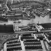
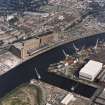
The Meadowside Quay was located on the north bank of the River Clyde, and built in stages extending eastwards over time. The first part, which was completed in 1907 and is depicted on the 3rd edition of the OS 25-inch map (Lanarkshire 1913, 006.0), ran between the Partick Sawmills (NS56NW 510) on the W and the Meadowside Shipbuilding Yard (NS56NE 2569) on the E. The quay, dotted with mooring posts and bucket elevators (later pneumatic suction elevators), served the Meadowside Granary (NS56NE 54) which was built in 1914, extended in 1937, 1960 and 1966, and demolished in 2002-3. Today, the Meadowside Quay Walk runs along the old quayside.
Information from HES Survey and Recording (AMcC) 14 July 2017.

