Pricing Change
New pricing for orders of material from this site will come into place shortly. Charges for supply of digital images, digitisation on demand, prints and licensing will be altered.
Connected with the Clyde 2


Date 2017 - 2018
Event ID 1024867
Category Project
Type Project
Permalink http://canmore.org.uk/event/1024867
This project, which was undertaken mainly in 2017, followed on from the first Connected with the Clyde Project (https://canmore.org.uk/project/995458) and upgraded about 360 existing Canmore records for which a direct association with the River Clyde could be demonstrated. The enhancements to the records included changing, when necessary, the location of the site, its classification and/or period; site descriptions were brought up to date and these were supported by a programme of photography. Several sites were also recorded through measured survey.

| Event | Type | Subtype | Notes | Date |
|---|---|---|---|---|
| 1026426 | RECORDING | DESK BASED ASSESSMENT | Prince’s Dock (NS56NE 4920), located on the south bank of the River Clyde in the Govan area of Glasgow, was designed by James Deas and constructed between 1892 and 1897. It was built primarily to cater for general cargo trade and comprised a large canting basin with associated quays and an entrance on the NW (NS56NE 4920) and (to the ESE of this) three basins (NS56SE 87.05-07 and NS56NE 4921) that lay parallel to the river (OS 25-inch 3rd edition map: Lanarkshire 1913, Sheets 006.09 and 006.10). [...] | 9 August 2017 |
| 1026827 | RECORDING | DESK BASED ASSESSMENT | The second of the three Govan Graving Docks, designed by James Deas and built by the Clyde Navigation Trust on the S bank of the River Clyde, opened in October 1886. It measures 575 feet (175m) long by 67 feet (20.4m) wide, with a depth of 22 feet 10 inches (7m) at high tide. The docks remained in use until 1988 but are now derelict. [...] | 15 August 2017 |
| 1026814 | RECORDING | DESK BASED ASSESSMENT | The tidal basin at William Denny and Brothers Ltd was situated at the southern end of the shipbuilding yard (NS47SW 91), on the west bank of the River Leven directly north of Dumbarton Rock. Rectangular on plan, it is first depicted on the 2nd edition of the OS 25-inch map (Dunbartonshire 1898, Sheet 022.06) and measured 200m from ENE to WSW by 62m transversely. Launched vessels were towed here to be fitted out with machinery and other internal furnishings. William Denny and Brothers Ltd. went in to liquidation in 1963 and the yard was later demolished, but a sawmill company later utilised the fitting-out basin. It has since been filled in and its site is now occupied Dumbarton Football Stadium (NS47SW 134), built in 2000. [...] | 14 August 2017 |


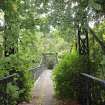
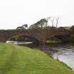
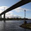
DP 262179
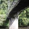
View of footbridge from NW
Historic Environment Scotland
14/9/2017
© Crown Copyright: HES

DP 262180
View of footbridge from SE
Historic Environment Scotland
14/9/2017
© Crown Copyright: HES

DP 262181
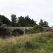
View of weir from E
Historic Environment Scotland
14/9/2017
© Crown Copyright: HES

DP 262182
View from WSW showing WNW and SSW fronts
Historic Environment Scotland
14/9/2017
© Crown Copyright: HES

DP 262183
View from SW showing SSW front
Historic Environment Scotland
14/9/2017
© Crown Copyright: HES

DP 262184
View from WSW showing SSW front
Historic Environment Scotland
14/9/2017
© Crown Copyright: HES

DP 262185
View from ENE
Historic Environment Scotland
14/9/2017
© Crown Copyright: HES

DP 262186
View from SE showing SSW front
Historic Environment Scotland
14/9/2017
© Crown Copyright: HES


DP 262188
Detail of gate from NE
Historic Environment Scotland
14/9/2017
© Crown Copyright: HES

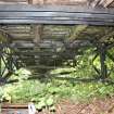
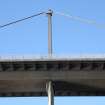
DP 262189
View of underside of bridge decking
Historic Environment Scotland
14/9/2017
© Crown Copyright: HES

DP 262190
View from ESE
Historic Environment Scotland
14/9/2017
© Crown Copyright: HES


DP 262193
View from SSW
Historic Environment Scotland
14/9/2017
© Crown Copyright: HES


DP 262195
View from NNE
Historic Environment Scotland
14/9/2017
© Crown Copyright: HES


DP 262197
Detail of panel
Historic Environment Scotland
14/9/2017
© Crown Copyright: HES

DP 262198
View from SSE
Historic Environment Scotland
14/9/2017
© Crown Copyright: HES


DP 262203
Detail from NE
Historic Environment Scotland
14/9/2017
© Crown Copyright: HES

DP 262204
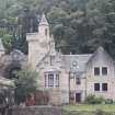
View from WSW
Historic Environment Scotland
14/9/2017
© Crown Copyright: HES

DP 262205
View from NNW
Historic Environment Scotland
14/9/2017
© Crown Copyright: HES

DP 262206
View from WSW
Historic Environment Scotland
14/9/2017
© Crown Copyright: HES


DP 262208
Detail from N
Historic Environment Scotland
14/9/2017
© Crown Copyright: HES

DP 262209
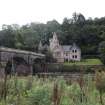
View from E with counting house in background
Historic Environment Scotland
14/9/2017
© Crown Copyright: HES

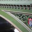
DP 263525
Detail of wrought ironwork with crest
Historic Environment Scotland
28/9/2017
© Crown Copyright: HES

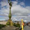
DP 263526
Detail of lamp
Historic Environment Scotland
28/9/2017
© Crown Copyright: HES

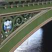
DP 263527
Detail of Glasgow coat of arms
Historic Environment Scotland
28/9/2017
© Crown Copyright: HES

DP 263528
Detail of arch showing wrought ironwork shield
Historic Environment Scotland
28/9/2017
© Crown Copyright: HES

DP 263532
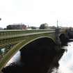
View from WSW
Historic Environment Scotland
28/9/2017
© Crown Copyright: HES

DP 263533
View from SSE
Historic Environment Scotland
28/9/2017
© Crown Copyright: HES

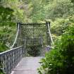
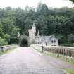
DP 263534
View of footbridge from S
Historic Environment Scotland
28/9/2017
© Crown Copyright: HES

DP 263535
View of footbridge from NNW
Historic Environment Scotland
28/9/2017
© Crown Copyright: HES


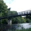
DP 263537
View from footbridge looking south to Cambuslang Bridge
Historic Environment Scotland
28/9/2017
© Crown Copyright: HES

DP 263538
View from ENE
Historic Environment Scotland
28/9/2017
© Crown Copyright: HES

DP 263539
View of Cambuslang footbridge (left) and Cambuslang Bridge (right) from NNW
Historic Environment Scotland
28/9/2017
© Crown Copyright: HES


DP 263541
Detail of memorial stone
Historic Environment Scotland
28/9/2017
© Crown Copyright: HES

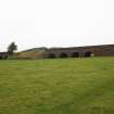
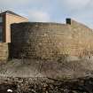
DP 263542
Detail of Harvie's Dyke from SE
Historic Environment Scotland
28/9/2017
© Crown Copyright: HES


DP 263544
View from NNW
Historic Environment Scotland
28/9/2017
© Crown Copyright: HES


DP 263546
View from NNW
Historic Environment Scotland
28/9/2017
© Crown Copyright: HES

DP 263547
View from WSW
Historic Environment Scotland
28/9/2017
© Crown Copyright: HES

DP 263548
View from WSW
Historic Environment Scotland
28/9/2017
© Crown Copyright: HES


DP 263550
View from SSE
Historic Environment Scotland
28/9/2017
© Crown Copyright: HES


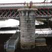
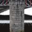
DP 263556
Detail of pier from S
Historic Environment Scotland
28/9/2017
© Crown Copyright: HES


DP 263558
View from WNW
Historic Environment Scotland
28/9/2017
© Crown Copyright: HES

DP 263559
View from NNE
Historic Environment Scotland
28/9/2017
© Crown Copyright: HES

DP 263560
View from ESE
Historic Environment Scotland
28/9/2017
© Crown Copyright: HES


DP 263563
View from ENE
Historic Environment Scotland
28/9/2017
© Crown Copyright: HES

DP 263564
Detail of second floor carved panels
Historic Environment Scotland
28/9/2017
© Crown Copyright: HES

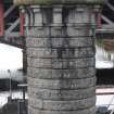
DP 263565
Detail of pier
Historic Environment Scotland
28/9/2017
© Crown Copyright: HES

DP 263566
Detail of pier
Historic Environment Scotland
28/9/2017
© Crown Copyright: HES

DP 263567
Detail of pier
Historic Environment Scotland
28/9/2017
© Crown Copyright: HES

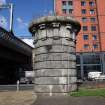
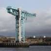
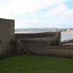
DP 264944
General view of mine watchers post, from ESE
Historic Environment Scotland
12/10/2017
© Crown Copyright: HES


DP 264946
View from SE
Historic Environment Scotland
12/10/2017
© Crown Copyright: HES

DP 264947
View from SW
Historic Environment Scotland
12/10/2017
© Crown Copyright: HES

DP 265204
View from NE
Historic Environment Scotland
12/10/2017
© Crown Copyright: HES

DP 265205
View from SE
Historic Environment Scotland
12/10/2017
© Crown Copyright: HES


DP 265208
View from SE
Historic Environment Scotland
12/10/2017
© Crown Copyright: HES

DP 265209
View from SW
Historic Environment Scotland
12/10/2017
© Crown Copyright: HES

DP 265651
Detail of monument inscription
Historic Environment Scotland
26/10/2017
© Crown Copyright: HES

DP 265652
View from NE
Historic Environment Scotland
26/10/2017
© Crown Copyright: HES

DP 265653
View from SE
Historic Environment Scotland
26/10/2017
© Crown Copyright: HES


DP 265655
View from SE
Historic Environment Scotland
26/10/2017
© Crown Copyright: HES

DP 265656
View from SE
Historic Environment Scotland
26/10/2017
© Crown Copyright: HES

DP 265657
View from WNW
Historic Environment Scotland
26/10/2017
© Crown Copyright: HES

DP 265658
View from NNW
Historic Environment Scotland
26/10/2017
© Crown Copyright: HES

DP 265659
Detail view of concrete drum
Historic Environment Scotland
26/10/2017
© Crown Copyright: HES

DP 265660
View from NW
Historic Environment Scotland
26/10/2017
© Crown Copyright: HES

DP 265661
View from WNW
Historic Environment Scotland
26/10/2017
© Crown Copyright: HES

DP 265662
View from ESE
Historic Environment Scotland
26/10/2017
© Crown Copyright: HES


DP 314659
View from SW showing blocked opening in the building adjacent to the possible searchlight platform.
Historic Environment Scotland
26/10/2017
© Copyright: HES