
Pricing Change
New pricing for orders of material from this site will come into place shortly. Charges for supply of digital images, digitisation on demand, prints and licensing will be altered.
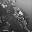
Port Glasgow, Ferguson Ailsa Shipyard


Shipyard (19th Century)
Site Name Port Glasgow, Ferguson Ailsa Shipyard
Classification Shipyard (19th Century)
Alternative Name(s) Lower Clyde; Newark Works; Castle Shipyard; Newark Shipbuilding Yard
Canmore ID 68380
Site Number NS37SW 37
NGR NS 3270 7457
NGR Description Centred NS 3270 7457
Datum OSGB36 - NGR
Permalink http://canmore.org.uk/site/68380


First 100 images shown. See the Collections panel (below) for a link to all digital images.
- Council Inverclyde
- Parish Port Glasgow
- Former Region Strathclyde
- Former District Inverclyde
- Former County Renfrewshire
NS37SW 37 centred 3270 7457
This shipyard was orginally founded around 1870 by Blackwood and Gordon. An example of a small shipbuilding and repairing yard with a complete engine works relatively little altered. There are several plateworking machines from the 19th century and two patent slips at the E end of the yard which were added around 1900 and later.
J R Hume (1976)
This is now known as Ferguson Shipbuilders Ltd. The site consists of an office block, East and West Fabrication Shops, Building Berth, outfitting quay, stores (general and joiner's) and workshops (joiner's and hydraulics). General engineering is carried out on site. Little shipbuilding or repair work is now carried out.
Visited by RCAHMS (MMD) 13 October 2009.
Port Glasgow, Ferguson Yard
Background
The original company was founded at the Newark site (adjacent to Newark Castle) in 1903 by the Ferguson Brothers, who subsequently acquired the freehold in 1907. The company and site changed hands in 1918, 1920 and 1961, eventually becoming part of the nationalised British Shipbuilders in 1977. It was then merged with Ailsa Shipbuilding Company in 1980. Ferguson’s then merged with Appledore of Devon and Clark Kincaid acquired the site in 1989, eventually selling to Kvaerner and then onto Ferguson Marine in 1991. Holland House Electrical Group acquired the company in 1995. The company on the site is now called Ferguson Shipbuilders Ltd. The site currently covers an area of approximately 30,220 square metres.
The site is depicted and named on the 2nd edition of the Ordnance Survey 25-inch map (Renfrewshire, 1897, sheet II.12) as ‘Newark Works (Disused)’ prior to it being taken over by the Ferguson Brothers in 1903. A mineral railway is also shown running along the SW edge of the site, connecting with the Caledonian Railway. The site is depicted and named as ‘Shipbuilding yard’ on the Ordnance Survey 25-inch map, Renfrewshire, 1913 and 1938, sheet II.12.
There are six cranes named and depicted at NS32645 74594, NS32721 74533, NS 32731 74510, NS32747 74509, NS32 757 74499 and NS3257 74468 on the Ordnance Survey Revision 25-inch map (Renfrewshire, 1938, sheet II.12). These are now gone.
The site was visited by RCAHMS in October and December 2009, as the company was reducing ship construction and diversifying into other fabrication and engineering markets.
West Ranges
The building at NS32702 74509 (adjacent to the West Fabrication Shed) appears to date from the post-1857 and pre-1897 period (see DP069300 and DP069301) and is the oldest surviving building on site, covering an area of approximately 1274 square metres. This building currently houses offices and its N end, W elevation and S end show remodelling (see DP069380 and DP069387). The NE arm of this building is shown on the 1897 map (Ordnance Survey Revision 25-inch map, Renfrewshire, 1938, sheet II.12) but is now gone. By 1897, the whole of the W range (including the surviving office area) covered an area of approximately 2498 square metres, by 1913 it covered approximately 3827 square metres and by 1938 this had increased to approximately 4383 square metres.
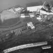
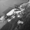
The current West Fabrication shed (DP069376-8) occupies the site of the earlier extension to the current Office Block and partly on reclaimed land. It covers (including the current Office Block range) approximately 3770 square metres. The West Fabrication Hall has two bays. Bay 1 measures 85m in length by 19m in width and has two entrances (4.76m in height and 7.96m in width and 4.49 in height and 4.07m in width respectively). It has two, 10 Ton overhead cranes, a Hancock bar/plate Burner (DP 069336), a Hugh Smith frame bar bender (DP 0693136), a Hugh Smith plate roller (DP06320-23 and DP069334), an office block and a bar store. Bay 2 measures 110m in length by 19m in width and has one entrance which measures 4.85m in height and 10.78m in width. It has a 10 ton magnetic lift crane (DP069314), a 10 Ton overhead crane, a 15 ton overhead crane, a 2.4m wide guillotine (maximum 15mm thick plate, see DP069318), a 500 Ton flanging machine (DP069319), a SMT plate mangle or roller (DP069316 and DP069317), a Messer plasma and gas cutting machine (DP069310-13; DP069315, and DP069340-44) and a plate store (DP069313).
East Ranges
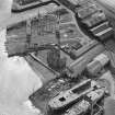
The brick built building at NS32781 74494 (see DP069302), which is incorporated into the East Fabrication Shed, was built after 1913 and had developed the footprint we see today by 1938.
The East Fabrication Shed has two bays. This building range which covered an area of 936 square metres in 1897, expanded to 1377 square metres by 1913 and 1665 square metres by 1938 (by which time Bay 2 had been added). Bay 1 of the East Fabrication Shed, pre-dates 1897 at its S end. It is constructed from brick with corrugated iron upper walls and has a ‘belfast’ roof at the original S end and a pitched roof and general structure similar to Bay 2 at its later N end. It measures 70m in length by 17.5m in width and has two entrances (6m in height and 8.7m in width and 6.6m in height and 7.9m in width respectively). It contains a 12.5 ton overhead crane and a 20 Ton overhead crane (DP 069289).
Bay 2 of the East Fabrication Shed and the N end of Bay 1 have a similar building style, although it would appear from map evidence that the shortened, rebuilt N end of Bay 1 was built before Bay 2 (Ordnance Survey 25-inch map of 1913, Renfrewshire, 1913, sheet II.12). Bay 2 measures 35m by 14m and has two entrances (6m in height and 8900m in width and 6.6m in height and 7.9m in width respectively) and contains a 25 Ton overhead crane and a mechanical and electrical plant department.
Outfitting Quay
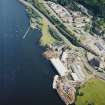
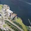
The Outfitting Quay (DP069345) is on land previously outwith the Newark yard extent as shown on the 1897 map. There are two quays. Quay 1 is 90m in length and is parallel to the river and dredged to 5m below Chart Datum. Quay 2 is 50m in length and adjacent to the river and also dredged to 5m below Chart Datum. There are eight 30 Ton mooring bollards, a compressor house and a paint workshop.
Building Berth
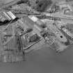
The Building Berth (DP069293, DP069303, DP069360-61, DP06391) measures 100 m in length by 40m in width and has a tower crane with a lift capacity of 16 tons at 19.4m in height to 6 tons at 45 m in height.
Other Buildings
The building housing the Pipe Fabrication Shop (measuring 45 m in length by 15m in width), General Store (measuring 48m in length by 17m in width), Joiners Workshop (measuring 33.9m in length by 26m in width) and Store (measuring 15.5m in length by 33.9m in width) and Ferguson Marine Hydraulic Workshop (measuring 18.8m in length by 12m in width) are housed in a modern building (DP069376).
Visited by RCAHMS (MMD), 12 October 2009.
http://www.archiveshub.ac.uk/news/0504scottlithgow.html, retrieved 24 February 2010; http://www.portglasgow4u.co.uk/Shipyards/Early_Shipyards.html, retrieved 24 February 2010; http://www.portglasgow4u.co.uk/Shipyards/datesowners.html, retrieved 24 February 2010; http://web.archive.org/web/20071011160001/http://www.fergusonshipbuilders.com/history.html, retrieved 24 February 2010.
Field Visit (2009)
This is now known as Ferguson Shipbuilders Ltd. The site consists of an office block, East and West Fabrication Shops, Building Berth, outfitting quay, stores (general and joiner's) and workshops (joiner's and hydraulics). General engineering is carried out on site. Little shipbuilding or repair work is now carried out.
Visited by RCAHMS (MMD) 13 October 2009.
Port Glasgow, Ferguson Yard
Background
The original company was founded at the Newark site (adjacent to Newark Castle) in 1903 by the Ferguson Brothers, who subsequently acquired the freehold in 1907. The company and site changed hands in 1918, 1920 and 1961, eventually becoming part of the nationalised British Shipbuilders in 1977. It was then merged with Ailsa Shipbuilding Company in 1980. Ferguson’s then merged with Appledore of Devon and Clark Kincaid acquired the site in 1989, eventually selling to Kvaerner and then onto Ferguson Marine in 1991. Holland House Electrical Group acquired the company in 1995. The company on the site is now called Ferguson Shipbuilders Ltd. The site currently covers an area of approximately 30,220 square metres.
The site is depicted and named on the 2nd edition of the Ordnance Survey 25-inch map (Renfrewshire, 1897, sheet II.12) as ‘Newark Works (Disused)’ prior to it being taken over by the Ferguson Brothers in 1903. A mineral railway is also shown running along the SW edge of the site, connecting with the Caledonian Railway. The site is depicted and named as ‘Shipbuilding yard’ on the Ordnance Survey 25-inch map, Renfrewshire, 1913 and 1938, sheet II.12.
There are six cranes named and depicted at NS32645 74594, NS32721 74533, NS 32731 74510, NS32747 74509, NS32 757 74499 and NS3257 74468 on the Ordnance Survey Revision 25-inch map (Renfrewshire, 1938, sheet II.12). These are now gone.
The site was visited by RCAHMS in October and December 2009, as the company was reducing ship construction and diversifying into other fabrication and engineering markets.
West Ranges
The building at NS32702 74509 (adjacent to the West Fabrication Shed) appears to date from the post-1857 and pre-1897 period (see DP069300 and DP069301) and is the oldest surviving building on site, covering an area of approximately 1274 square metres. This building currently houses offices and its N end, W elevation and S end show remodelling (see DP069380 and DP069387). The NE arm of this building is shown on the 1897 map (Ordnance Survey Revision 25-inch map, Renfrewshire, 1938, sheet II.12) but is now gone. By 1897, the whole of the W range (including the surviving office area) covered an area of approximately 2498 square metres, by 1913 it covered approximately 3827 square metres and by 1938 this had increased to approximately 4383 square metres.
The current West Fabrication shed (DP069376-8) occupies the site of the earlier extension to the current Office Block and partly on reclaimed land. It covers (including the current Office Block range) approximately 3770 square metres. The West Fabrication Hall has two bays. Bay 1 measures 85m in length by 19m in width and has two entrances (4.76m in height and 7.96m in width and 4.49 in height and 4.07m in width respectively). It has two, 10 Ton overhead cranes, a Hancock bar/plate Burner (DP 069336), a Hugh Smith frame bar bender (DP 0693136), a Hugh Smith plate roller (DP06320-23 and DP069334), an office block and a bar store. Bay 2 measures 110m in length by 19m in width and has one entrance which measures 4.85m in height and 10.78m in width. It has a 10 ton magnetic lift crane (DP069314), a 10 Ton overhead crane, a 15 ton overhead crane, a 2.4m wide guillotine (maximum 15mm thick plate, see DP069318), a 500 Ton flanging machine (DP069319), a SMT plate mangle or roller (DP069316 and DP069317), a Messer plasma and gas cutting machine (DP069310-13; DP069315, and DP069340-44) and a plate store (DP069313).
East Ranges
The brick built building at NS32781 74494 (see DP069302), which is incorporated into the East Fabrication Shed, was built after 1913 and had developed the footprint we see today by 1938.
The East Fabrication Shed has two bays. This building range which covered an area of 936 square metres in 1897, expanded to 1377 square metres by 1913 and 1665 square metres by 1938 (by which time Bay 2 had been added). Bay 1 of the East Fabrication Shed, pre-dates 1897 at its S end. It is constructed from brick with corrugated iron upper walls and has a ‘belfast’ roof at the original S end and a pitched roof and general structure similar to Bay 2 at its later N end. It measures 70m in length by 17.5m in width and has two entrances (6m in height and 8.7m in width and 6.6m in height and 7.9m in width respectively). It contains a 12.5 ton overhead crane and a 20 Ton overhead crane (DP 069289).
Bay 2 of the East Fabrication Shed and the N end of Bay 1 have a similar building style, although it would appear from map evidence that the shortened, rebuilt N end of Bay 1 was built before Bay 2 (Ordnance Survey 25-inch map of 1913, Renfrewshire, 1913, sheet II.12). Bay 2 measures 35m by 14m and has two entrances (6m in height and 8900m in width and 6.6m in height and 7.9m in width respectively) and contains a 25 Ton overhead crane and a mechanical and electrical plant department.
Outfitting Quay
The Outfitting Quay (DP069345) is on land previously outwith the Newark yard extent as shown on the 1897 map. There are two quays. Quay 1 is 90m in length and is parallel to the river and dredged to 5m below Chart Datum. Quay 2 is 50m in length and adjacent to the river and also dredged to 5m below Chart Datum. There are eight 30 Ton mooring bollards, a compressor house and a paint workshop.
Building Berth
The Building Berth (DP069293, DP069303, DP069360-61, DP06391) measures 100 m in length by 40m in width and has a tower crane with a lift capacity of 16 tons at 19.4m in height to 6 tons at 45 m in height.
Other Buildings
The building housing the Pipe Fabrication Shop (measuring 45 m in length by 15m in width), General Store (measuring 48m in length by 17m in width), Joiners Workshop (measuring 33.9m in length by 26m in width) and Store (measuring 15.5m in length by 33.9m in width) and Ferguson Marine Hydraulic Workshop (measuring 18.8m in length by 12m in width) are housed in a modern building (DP069376).
Visited by RCAHMS (MMD), 12 October 2009.
http://www.archiveshub.ac.uk/news/0504scottlithgow.html, retrieved 24 February 2010; http://www.portglasgow4u.co.uk/Shipyards/Early_Shipyards.html, retrieved 24 February 2010; http://www.portglasgow4u.co.uk/Shipyards/datesowners.html, retrieved 24 February 2010; http://web.archive.org/web/20071011160001/http://www.fergusonshipbuilders.com/history.html, retrieved 24 February 2010.
Project (May 2016 - September 2017)
Running from May 2016 to September 2017 and part of the Canmore Mapping Programme, Yard by Yard was an area-focused, desk-based project that tested the Defining Scotland’s Places (DSP) methodology in an area for which the records in the NRHE showed considerable variation from one historic map source to another.
Following discussions with local heritage groups and with the ambition of collecting data useful to the communities’ ambition to develop a coastal heritage trail, the project aimed to map the extent of the shipyards and associated industry between Port Glasgow and Greenock. To achieve this aim, the project used historic mapping, ortho-rectified modern aerial photography and the HES aerial photograph collection to map the extents of, and upgrade the records of, the shipyards and associated features such as quays, docks, areas of land reclamation and associated industry.
Field Visit (5 July 2017)
What may be the last vestiges of the outer circumference of a ship turntable (NS 32623 74493) were noted in the car park SSE of some temporary offices of Ferguson Marine. This turntable is depicted on an aerial photograph (CPA/Scot/UK/0235 FFO 0007) flown on 5 July 1947, when seven sheds were arranged radially upon it, with a slipway in the gap between them sloping gently down to the dock on the WNW. It is also shown on an aerial photograph (SC 1438083) flown on 6 June 1953, when only the foundations of the sheds remained.
An earlier, undated photograph (A29942), taken by Lieutenant E.A. Zimmerman (a Royal Navy Official photographer during the Second World War) is in the ‘Admiralty Official Collection’ curated by the Imperial War Museum. The caption reads, ‘The Landing Craft Maintenance Base at Port Glasgow seen from the East end’.
Visited by HES (ATW, ARG) 5 July 2017

