Following the launch of trove.scot in February 2025 we are now planning the retiral of some of our webservices. Canmore will be switched off on 24th June 2025. Information about the closure can be found on the HES website: Retiral of HES web services | Historic Environment Scotland
Aerial Defences of the Clyde


Date January 2017 - October 2019
Event ID 1024281
Category Project
Type Project
Permalink http://canmore.org.uk/event/1024281
An archaeological survey was undertaken between January 2017 and October 2019 to determine the infrastructure that had been set in place by the War Office and the Air Ministry to protect the City of Glasgow and the River Clyde from aerial attack during both the Second World War and the Post-War period. The survey covered an area extending from the Isle of Bute in the west to Carluke in the east, and from Loch Lomond in the north to Kilmarnock in the south. The aims of the survey were to establish the characteristics of this defence and what physical remains might still be observed and recorded in the field, and to enhance the National Record of the Historic Environment (NRHE) curated by Historic Environment Scotland (HES). This project was built on a recognition of the value of recording military archaeology across the country (Forbes, Page and Perez 2009; Lowry 1996) and complemented the fieldwork undertaken by Tam Ward and the North Clyde Archaeological Society (*), who had examined the surviving aerial defences in the West Dunbarton area.
The first phase of the project comprised data collection and analysis by Allan Kilpatrick with the assistance of Anne Landskron, drawing on sources held by the National Archives at Kew (TNA), Aerial Photography and existing records in the NHRE. Sources of information included the War Office files of the Anti-Aircraft Command and various war diaries connected with the units that were engaged on the sites. In addition, aerial photographs taken by the RAF, the Luftwaffe and Aerofilms were examined for the location of those elements that were not closely identified in the written and mapped resources. Where Cassini grid coordinates were provided in the cotemporary documentation these were evaluated and often proved helpful, but their accuracy was variable.
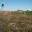
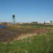
A database of 982 entries was compiled from the desk-based work. This included Ammunition Depots (3), Barrage Balloon Stations (136), a Barrage Balloon Depot (1), Decoys (19), Unit Head Quarters (5), Heavy Anti-Aircraft Batteries (43), Light Ant-Aircraft Batteries (61), Post-war Anti-Aircraft Batteries (26), Mine Watcher’s Observation Posts (9), Searchlight Batteries (140) and Rocket Projector Batteries (6). In addition, Air Raid Shelters were added when they were encountered (4), together with those Bomb Craters (529) that lay outside the urban areas of Clydebank, Greenock and Dumbarton, which had already been documented (National Record of Scotland HH50/162). However, Anti-Glider Defences (2) were not systematically collected. Many of the individual sites were made up of complex components, sometimes spread over an extensive area. These included the decoys and the camps for the personnel who serviced the larger batteries.
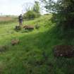
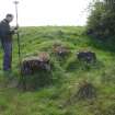
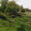
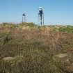
The second phase of the project constituted the fieldwork, which aimed to visit the locations of the sites identified during the desk-based work where that was deemed useful. This was informed by maps and relevant photographs, but certain sites were not visited because the desk-based work had established that nothing survived on the surface at their location. Otherwise, almost every site was visited where remains were thought to be extant, where there was some uncertainty as to whether anything survived, or where there were questions as to their character.
Fieldwork was generally undertaken by teams managed by Adam Welfare and Allan Kilpatrick, with participation by Angela Gannon, George Geddes, Alex Hale, Alison McCaig, Katerina Gilmour and Sazya Zeefat.
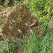
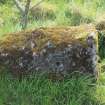
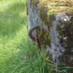
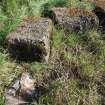
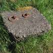
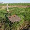
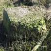
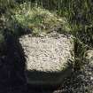
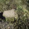
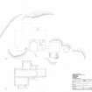
Extant remains were mapped in outline with a Leica differential GPS and also noted and photographed. In a few instances, detailed plans and elevations were produced with a plane table at a scale of 1:100 or from the GPS linework. They were then redrawn in vector graphics software at scales of 1:50, 1:200, or 1:250. These sites included the Command Posts at the Heavy Anti-Aircraft Gun Batteries at Carmunnock (Canmore ID: 43809, SC2145021) and High Mathernock (Canmore ID: 106359, SC2145022), the decoy control shelters at Auchenreoch Muir (Canmore ID: 229065, SC2145015) and Gleniffer Braes (Canmore ID: 232038, SC2145019), one of the Mine Watcher’s Observation Posts at Bowling (Canmore ID: 320143, SC1593032), the earthworks connected with the Light Anti-Aircraft Batteries at Barochan Hill (Canmore ID: 206087, SC1777690), Boghall Cottage (Canmore ID: 356323, SC17777685) and Flatterton (Canmore ID: 105645, SC1779561), and an air raid shelter at Balnakailly Bay on the Isle of Bute (Canmore ID: 305084, SC2142344).
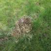
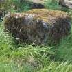
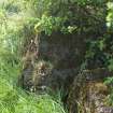
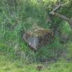
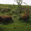
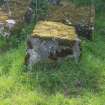
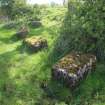
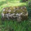
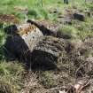
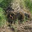
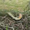
Significant discoveries during fieldwork demonstrated the value of the close inspection of a site on the ground. These included the shallow concentric rings of anchor pits in the turf at the Barrage Balloon Station on Glasgow Green (Canmore ID: 354721), the extensive range of surviving remains at the Auchenreoch Muir decoy (Canmore ID: 229065), the identification of small circular embanked earthworks for drums of burning oil in the decoys at Douglasmuir (Canmore ID: 229137) and Gleniffer Braes (Canmore ID: 232038), and the rusting remnants of the original large metal tanks that were also used for burning oil at the Balnakailly Bay decoy (Canmore ID: 305084). In addition, the recognition of the Emergency Rapid Deployment Anti-Aircraft Batteries of the Post-war period at Gleniffer Braes (Canmore ID: 107526) and Blairskaith Muir (Canmore ID: 294587) is exceptional, as this type of structure has rarely left surface remains. Moreover, several additions to the number of known Mine Watcher’s Observation Posts suggest the systematic reporting of enemy bombings, while the survey also provided an improved understanding of the evolution of the Heavy Anti-Aircraft Gun emplacements. Other noteworthy outcomes included the large area covered by the searchlight batteries, the density of the Barrage Balloons over the urban areas, and both the number and the distribution of the German bomb craters peppering the moorlands.
Following the completion of the fieldwork, the survey linework was archived and site area polygons were drawn. The classifications and written descriptions for pre-existing NRHE records were checked and refreshed where necessary, while entries were created for 239 previously unrecorded sites. The NHRE records were further enhanced by 275 ground photographs taken during the survey.
Information from HES Archaeological Survey (A.T. Welfare and A. K. Kilpatrick), 30 September 2019
* http://www.spanglefish.com/northclydearchaeologicalsociety/index.asp?pageid=514452