
Following the launch of trove.scot in February 2025 we are now planning the retiral of some of our webservices. Canmore will be switched off on 24th June 2025. Information about the closure can be found on the HES website: Retiral of HES web services | Historic Environment Scotland
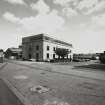
Edinburgh, Wheatfield Road, North British Distillery


Distillery (19th Century) (1885)
Site Name Edinburgh, Wheatfield Road, North British Distillery
Classification Distillery (19th Century) (1885)
Canmore ID 68132
Site Number NT27SW 112
NGR NT 22950 72588
Datum OSGB36 - NGR
Permalink http://canmore.org.uk/site/68132
Ordnance Survey licence number AC0000807262. All rights reserved.
Canmore Disclaimer.
© Bluesky International Limited 2025. Public Sector Viewing Terms
- Correction
- Favourite

SC 743790
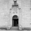
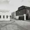
Detail of main entrance to Distillery Offices, viewed from south west, North British Distillery, Edinburgh Digital image of C 5630
Records of the Royal Commission on the Ancient and Historical Monuments of Scotland (RCAHMS), Edinbu
18/5/1993
© Crown Copyright: HES

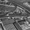
SC 1246190
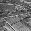
T and H Smith's works, Wheatfield Road, Edinburgh. Oblique aerial photograph taken facing west.
Records of Aerofilms Ltd, aerial photographers, Bristol, England
1/5/1927
© Copyright: HES (Aerofilms Collection)

SC 1246230
T and H Smith's works, Wheatfield Road, Edinburgh. Oblique aerial photograph taken facing north.
Records of Aerofilms Ltd, aerial photographers, Bristol, England
1/5/1927
© Copyright: HES (Aerofilms Collection)

SC 1677313
General oblique aerial view.
RCAHMS Aerial Photography
1993
© Crown Copyright: HES

SC 1677452
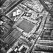
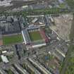
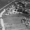
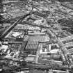
General oblique aerial view centred on the football ground and stadium with the whisky distillery adjacent, taken from the W.
RCAHMS Aerial Photography
29/5/2003
© Crown Copyright: HES

SC 2661945
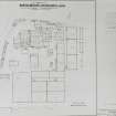
Photographic copy of plan of the North British Distillery plant, Gorgie
1971
© RCAHMS

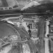
SC 2661987
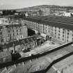
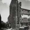
Elevated view from south east (on floodlight tower of Tynecastle Stadium) of range containing Duty Free Warehouses Nos. 5, 6 and 7 (6 roofless), and in background, Still House.
Records of the Royal Commission on the Ancient and Historical Monuments of Scotland (RCAHMS), Edinbu
20/4/1993
© Crown Copyright: HES

SC 2661991
Elevated view from east south east (on SW floodlight tower of Tynecastle Stadium) of Duty Free Warehouses Nos. 3 and 4, with neighbouring Blandfield Chemical Works and Murrayfield Stadium (being re-built) in the background
Records of the Royal Commission on the Ancient and Historical Monuments of Scotland (RCAHMS), Edinbu
20/4/1993
© Crown Copyright: HES

SC 2661996
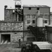
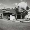
View from south south east of Carbon Dioxide Plant tanks and cooling tower
Records of the Royal Commission on the Ancient and Historical Monuments of Scotland (RCAHMS), Edinbu
18/5/1993
© Crown Copyright: HES

SC 2662000
View from south of Spirit Store, with J & B Whisky road tanker being filled with grain whisky.
Records of the Royal Commission on the Ancient and Historical Monuments of Scotland (RCAHMS), Edinbu
18/5/1993
© Crown Copyright: HES

SC 2662006
View from south west of Excise Office
Records of the Royal Commission on the Ancient and Historical Monuments of Scotland (RCAHMS), Edinbu
18/5/1993
© Crown Copyright: HES

SC 743784
Elevated view from south east (on south west floodlight tower of Tynecastle Stadium) of Duty Free Warehouses Nos. 3 and 4, with Still House block and Tun Room etc. in background. Digital image of C 5108 CN
Records of the Royal Commission on the Ancient and Historical Monuments of Scotland (RCAHMS), Edinbu
20/4/1993
© Crown Copyright: HES

SC 2661989
Elevated view from east south east (on floodlight tower of Tynecastle Stadium) of Duty Free Warehouses No. 5, with Duty Free warehouse No. 1 (extreme left), Still House (right) and in distance, Blandfield Chemical Works
Records of the Royal Commission on the Ancient and Historical Monuments of Scotland (RCAHMS), Edinbu
20/4/1993
© Crown Copyright: HES

SC 2661995
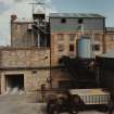
View of south east of range of buildings at west side of works, containing garages, electrical switchroom, electricians' workshop and store, canteen (upper floor), plumbers' shop, paint shop and in the distance, tanks of the Carbon Dioxide Plant.
Records of the Royal Commission on the Ancient and Historical Monuments of Scotland (RCAHMS), Edinbu
18/5/1993
© Crown Copyright: HES

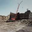
SC 2662014
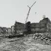
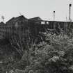
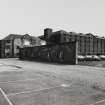
View from south of Duty Free Warehouses No. 7 during demolition
Records of the Royal Commission on the Ancient and Historical Monuments of Scotland (RCAHMS), Edinbu
18/5/1993
© Crown Copyright: HES

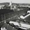
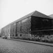
SC 590223
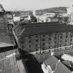
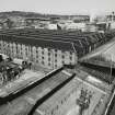
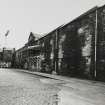
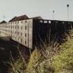
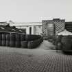
Edinburgh, Wheatfield Road, North British Distillery, Bonded Warehouse General View
Papers of Professor John R Hume, economic and industrial historian, Glasgow, Scotland
15/2/1967
© Copyright: HES (Reproduced courtesy of J R Hume)

SC 743780
View from east of south east corner of Tun Room block, withpart of Still House visible (right). Digital image of C 5637
Records of the Royal Commission on the Ancient and Historical Monuments of Scotland (RCAHMS), Edinbu
18/5/1993
© Crown Copyright: HES

SC 1246189
T and H Smith's works, Wheatfield Road, Edinburgh. Oblique aerial photograph taken facing north.
Records of Aerofilms Ltd, aerial photographers, Bristol, England
1/5/1927
© Copyright: HES (Aerofilms Collection)

SC 1246193
T and H Smith's works, Wheatfield Road, Edinburgh. Oblique aerial photograph taken facing west.
Records of Aerofilms Ltd, aerial photographers, Bristol, England
1/5/1927
© Copyright: HES (Aerofilms Collection)

SC 1246229
T and H Smith's works, Wheatfield Road, Edinburgh. Oblique aerial photograph taken facing north.
Records of Aerofilms Ltd, aerial photographers, Bristol, England
1/5/1927
© Copyright: HES (Aerofilms Collection)

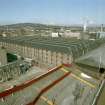
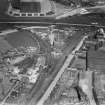
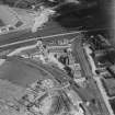
SC 1677312
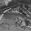
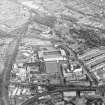
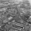
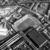
General aerial view of Gorgie, including Robertson Avenue Bakery, Wheatfield Road North British Distillery, Tynecastle Park Stadium, Murrayfield Stadium and Wheatfield Road Blandfield Chemical Works.
RCAHMS Aerial Photography
1993
© Crown Copyright: HES

SC 2661988
Elevated view from south east (on floodlight tower of Tynecastle Stadium) of range containing Duty Free Warehouses Nos. 5, 6 and 7 (6 roofless), and in background, Still House.
Records of the Royal Commission on the Ancient and Historical Monuments of Scotland (RCAHMS), Edinbu
20/4/1993
© Crown Copyright: HES

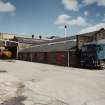
SC 2662007
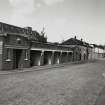
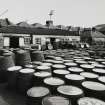
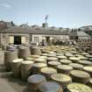
View from north west of Coopers building and cask yard
Records of the Royal Commission on the Ancient and Historical Monuments of Scotland (RCAHMS), Edinbu
18/5/1993
© Crown Copyright: HES

SC 2662012
View from north west of Duty Free Warehouses Nos. 6 and 5 during demolition
Records of the Royal Commission on the Ancient and Historical Monuments of Scotland (RCAHMS), Edinbu
18/5/1993
© Crown Copyright: HES

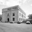
SC 743792
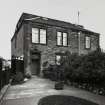
View of Distillery Offices from south west Digital image of C 5629
Records of the Royal Commission on the Ancient and Historical Monuments of Scotland (RCAHMS), Edinbu
18/5/1993
© Crown Copyright: HES

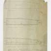
DP 002043
Floor and roof plans.
Records of Lorimer and Matthew, architects, Edinburgh, Scotland
c. 1956
© Courtesy of HES (Records of Lorimer and Matthew, architects, Edinburgh, Scotland)

SC 1246188
T and H Smith's works, Wheatfield Road, Edinburgh. Oblique aerial photograph taken facing north.
Records of Aerofilms Ltd, aerial photographers, Bristol, England
1/5/1927
© Copyright: HES (Aerofilms Collection)

SC 1246191
T and H Smith's works, Wheatfield Road, Edinburgh. Oblique aerial photograph taken facing north-east.
Records of Aerofilms Ltd, aerial photographers, Bristol, England
1/5/1927
© Copyright: HES (Aerofilms Collection)

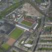
SC 1679384
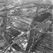
Aerial view of North British Distillery and Tynecastle Park Stadium
RCAHMS Aerial Photography
1993
© Crown Copyright: HES

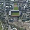
SC 1679691
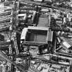
Oblique aerial view of Edinburgh centred on Tynecastle Park Stadium and the North British Distillery, taken from the NE.
RCAHMS Aerial Photography
2/3/1998
© Crown Copyright: HES

SC 2661990
Elevated view from south east (on south west floodlight tower of Tynecastle Stadium) of Duty Free Warehouses Nos. 3 and 4, with Still House block and Tun Room etc. in background.
Records of the Royal Commission on the Ancient and Historical Monuments of Scotland (RCAHMS), Edinbu
20/4/1993
© Crown Copyright: HES

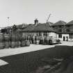
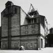
SC 2661992
View of Gatehouse and Distillery House from south
Records of the Royal Commission on the Ancient and Historical Monuments of Scotland (RCAHMS), Edinbu
18/5/1993
© Crown Copyright: HES

SC 2661993
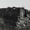
View of Distillery House from south (dated 1886)
Records of the Royal Commission on the Ancient and Historical Monuments of Scotland (RCAHMS), Edinbu
18/5/1993
© Crown Copyright: HES

SC 2661994
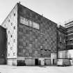
View of Distillery Offices from south
Records of the Royal Commission on the Ancient and Historical Monuments of Scotland (RCAHMS), Edinbu
18/5/1993
© Crown Copyright: HES

SC 2661999
View from west along north frontage of Duty Free warehouse No. 1
Records of the Royal Commission on the Ancient and Historical Monuments of Scotland (RCAHMS), Edinbu
18/5/1993
© Crown Copyright: HES

SC 2662002
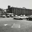
View from west of west side of Duty Free warehouses Nos. 1 (left) and 4 (right), viewed across car park area, which was created by the demolition of other duty free warehouses.
Records of the Royal Commission on the Ancient and Historical Monuments of Scotland (RCAHMS), Edinbu
18/5/1993
© Crown Copyright: HES

SC 2662009
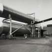
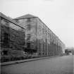
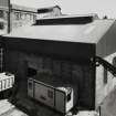
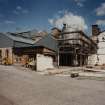
Elevated view from west south west of Mash House block, showing grain and green malt intakes.
Records of the Royal Commission on the Ancient and Historical Monuments of Scotland (RCAHMS), Edinbu
18/5/1993
© Crown Copyright: HES

SC 2662010
Elevated view from north west of west wing of Mash House block, containing cookers.
Records of the Royal Commission on the Ancient and Historical Monuments of Scotland (RCAHMS), Edinbu
18/5/1993
© Crown Copyright: HES

SC 2662011
View from north west of block containing Silos, with entrance to grain intake bay (right).
Records of the Royal Commission on the Ancient and Historical Monuments of Scotland (RCAHMS), Edinbu
18/5/1993
© Crown Copyright: HES

SC 590222
Edinburgh, Wheatfield Road, North British Distillery, Bonded Warehouse General View
Papers of Professor John R Hume, economic and industrial historian, Glasgow, Scotland
15/2/1967
© Copyright: HES (Reproduced courtesy of J R Hume)

DP 041803
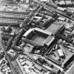
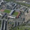
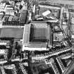
Oblique aerial view centred on the football stadium with the distillery adjacent, taken from the S.
RCAHMS Aerial Photography Digital
7/5/2008
© Crown Copyright: HES

DP 041804
Oblique aerial view centred on the football stadium with the distillery adjacent, taken from the SE.
RCAHMS Aerial Photography Digital
7/5/2008
© Crown Copyright: HES

SC 1678820
Oblique aerial view centred on the bonded warehouse with the whisky distillery and the pumphouse and pavilion adjacent, taken from the WSW.
RCAHMS Aerial Photography
29/5/2003
© Crown Copyright: HES

SC 1679291
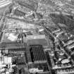
Aerial view of Tynecastle football ground and North British Distillery
RCAHMS Aerial Photography
1988
© Crown Copyright: HES

SC 2661997
View from west of Duty Free Warehouse No. 1 (left) and tall blocks (right) comprising Duty Free Warehouses Nos. 3 and 4.
Records of the Royal Commission on the Ancient and Historical Monuments of Scotland (RCAHMS), Edinbu
18/5/1993
© Crown Copyright: HES

SC 2662001
View from south of Spirit Store, with J & B WHisky road tanker being filled with grain whisky.
Records of the Royal Commission on the Ancient and Historical Monuments of Scotland (RCAHMS), Edinbu
18/5/1993
© Crown Copyright: HES

SC 2662003
View from south west across Empty Cask storage area (previously the site of duty free warehouses), looking towards Duty Free Warehouse No. 4
Records of the Royal Commission on the Ancient and Historical Monuments of Scotland (RCAHMS), Edinbu
18/5/1993
© Crown Copyright: HES

SC 2662005
View from south west of block containing Mash House, with remains of kilns (right).
Records of the Royal Commission on the Ancient and Historical Monuments of Scotland (RCAHMS), Edinbu
18/5/1993
© Crown Copyright: HES

SC 1246192
T and H Smith's works, Wheatfield Road, Edinburgh. Oblique aerial photograph taken facing north-east.
Records of Aerofilms Ltd, aerial photographers, Bristol, England
1/5/1927
© Copyright: HES (Aerofilms Collection)

SC 1679690
Oblique aerial view of Edinburgh centred on Tynecastle Park Stadium and the North British Distillery, taken from the ENE.
RCAHMS Aerial Photography
2/3/1998
© Crown Copyright: HES

SC 1679695
Oblique aerial view of Edinburgh centred on Tynecastle Park Stadium and the North British Distillery, taken from the SSE.
RCAHMS Aerial Photography
2/3/1998
© Crown Copyright: HES

SC 2661984
View from north east of range containing Duty Free Warehouses Nos. 7, 6 and 5 during demolition.
Records of the Royal Commission on the Ancient and Historical Monuments of Scotland (RCAHMS), Edinbu
20/4/1993
© Crown Copyright: HES

SC 2662004
View from south south east across Cask Yard towards Still House and Tun Room block
Records of the Royal Commission on the Ancient and Historical Monuments of Scotland (RCAHMS), Edinbu
18/5/1993
© Crown Copyright: HES

SC 2662008
Elevated view from west south west of Mash House block, showing grain and green malt intakes.
Records of the Royal Commission on the Ancient and Historical Monuments of Scotland (RCAHMS), Edinbu
18/5/1993
© Crown Copyright: HES

SC 2662015
General view from south west of Mash House block, with remains of kilns (right).
Records of the Royal Commission on the Ancient and Historical Monuments of Scotland (RCAHMS), Edinbu
18/5/1993
© Crown Copyright: HES

SC 743781
View from north west of Coopers building and cask yard, North British Distillery, Edinburgh
Records of the Royal Commission on the Ancient and Historical Monuments of Scotland (RCAHMS), Edinbu
18/5/1993
© Crown Copyright: HES

DP 041805
Oblique aerial view of Edinburgh centred on the Tynecastle Park football stadium with the North British Distillery adjacent and Murrayfield Stadium in the background, taken from the SE.
RCAHMS Aerial Photography Digital
7/5/2008
© Crown Copyright: HES

SC 2662013
View from north west of Duty Free Warehouses Nos. 6 and 5 during demolition
Records of the Royal Commission on the Ancient and Historical Monuments of Scotland (RCAHMS), Edinbu
18/5/1993
© Crown Copyright: HES

DP 041802
Oblique aerial view centred on the football stadium with the distillery adjacent, taken from the SW.
RCAHMS Aerial Photography Digital
7/5/2008
© Crown Copyright: HES

DP 041806
Oblique aerial view centred onTynecastle Park, Heart of Midlothian Football clubs stadium, with the distillery adjacent, taken from the East North-East.
RCAHMS Aerial Photography Digital
7/5/2008
© Crown Copyright: HES

SC 1677453
General oblique aerial view centred on the football ground and stadium with the whisky distillery adjacent, taken from the SE.
RCAHMS Aerial Photography
29/5/2003
© Crown Copyright: HES

SC 1679292
Aerial view of Tynecastle football ground and North British Distillery
RCAHMS Aerial Photography
1988
© Crown Copyright: HES

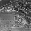
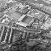
SC 1679383
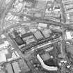
General aerial view showing Wheatfield Road, North British Distillery and Gorgie Road, Tynecastle Park Stadium
RCAHMS Aerial Photography
1993
© Crown Copyright: HES

SC 2661985
View from north east of range containing Duty Free Warehouses Nos. 7, 6 and 5 during demolition.
Records of the Royal Commission on the Ancient and Historical Monuments of Scotland (RCAHMS), Edinbu
20/4/1993
© Crown Copyright: HES

SC 2661986
View from north north west of range containing Duty Free Warehouses Nos. 7, 6 and 5 during demolition.
Records of the Royal Commission on the Ancient and Historical Monuments of Scotland (RCAHMS), Edinbu
20/4/1993
© Crown Copyright: HES

SC 2661998
View from west of Duty Free Warehouse No. 1 (left) and tall blocks (right) comprising Duty Free Warehouses Nos. 3 and 4.
Records of the Royal Commission on the Ancient and Historical Monuments of Scotland (RCAHMS), Edinbu
18/5/1993
© Crown Copyright: HES

SC 2662016
View from south west of Mash House block, with remains of kilns (right)
Records of the Royal Commission on the Ancient and Historical Monuments of Scotland (RCAHMS), Edinbu
18/5/1993
© Crown Copyright: HES

- Council Edinburgh, City Of
- Parish Edinburgh (Edinburgh, City Of)
- Former Region Lothian
- Former District City Of Edinburgh
- Former County Midlothian
Note (27 January 2014)
For Westfield warehouses built to accommodate grain whisky production at the North British Distillery, see NT27SW 4574.
Information from RCAHMS (HDS) 27 January 2014
Field Visit (17 November 2021)
Site assessed for designation in 2021-22. The designation report is available on our Heritage Portal.
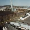
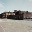
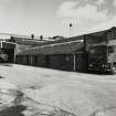
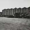
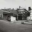
The North British Distillery is a multi-phase distillery site, established in 1885-86 by Andrew Usher, William Sanderson and John Crabbie.
The site comprises a gatehouse (dated 1886), an L-plan bonded warehouse range (built around 1886), a former filling house (dated 1891), a 1930s distillery office, a range of workshops and related distillery buildings and structures which have been altered and extended in the 20th and early-21st centuries.
Visited by HES Designations (REMB) 17 November 2021.

