
Pricing Change
New pricing for orders of material from this site will come into place shortly. Charges for supply of digital images, digitisation on demand, prints and licensing will be altered.
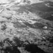
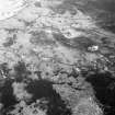
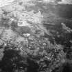
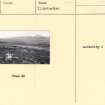
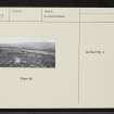
Cnoc Dail-chairn


Cairn (Prehistoric)
Site Name Cnoc Dail-chairn
Classification Cairn (Prehistoric)
Canmore ID 6644
Site Number NC82NE 17
NGR NC 8540 2886
Datum OSGB36 - NGR
Permalink http://canmore.org.uk/site/6644


- Council Highland
- Parish Kildonan
- Former Region Highland
- Former District Sutherland
- Former County Sutherland
Field Visit (30 May 1961)
NC82NE 17 8540 2886
See also NC82NE 16.
(NC 8540 2886) Cairn (NR)
OS 6" map, 1962.
A cairn, 14m in diameter and 1.3m high, partly heather-grown, found during field investigation.
Visited by OS (E G C) 30 May 1961
Field Visit (17 January 1977)
This cairn as described is prominently situated on a natural terrace on the undulating north slope of Cnoc Dail-chairn within a minor field system associated with a hut circle (See NC82NE 16). Kerbstones are visible intermittently on the perimeter; on the east side the kerb is particularly well-preserved, where there is a straight line of boulders up to 0.8m high and 7.5m long in the manner of a facade, though there is no break for an entrance passage. The centre of the cairn is disturbed revealing a content of rubble stones.
Visited by OS (J B) 17 January 1977
Field Visit (2 May 1991)
This cairn is situated on a natural terrace on the N flank of Cnoc Dail-chairn within the area of an extensive field-system (NC82NE 16). It measures 13.7m from N to S by 13m transversely and 1m in height. The mound is surrounded by the remains of an orthostatic kerb with stones up to 0.75m high; on the E there is a straight stretch of kerb 7.5m in length and elsewhere there are what appear to be facets within the kerb, suggesting that the cairn may be an octagonal on plan. A hut has been built in the disturbed stonework on top of the cairn. The straight stretch of kerbing on the E suggests that the cairn may be chambered. (KILD91 220)
Visited by RCAHMS (DCC) 2 May 1991.

