
Caerlaverock Castle


Castle (Medieval), Axehead(S) (Bronze)(Bronze Age), Flake (Chert)(Period Unassigned)
Site Name Caerlaverock Castle
Classification Castle (Medieval), Axehead(S) (Bronze)(Bronze Age), Flake (Chert)(Period Unassigned)
Alternative Name(s) Carlaverock
Canmore ID 66100
Site Number NY06NW 6
NGR NY 02548 65638
Datum OSGB36 - NGR
Permalink http://canmore.org.uk/site/66100


First 100 images shown. See the Collections panel (below) for a link to all digital images.
- Council Dumfries And Galloway
- Parish Caerlaverock
- Former Region Dumfries And Galloway
- Former District Nithsdale
- Former County Dumfries-shire
NY06NW 6 02548 65638.
For Old Caerlaverock Castle (NY 027 654), see NY06NW 7.
See also NY06NW 12.
(NY 0255 6561) Caerlaverock Castle (NR)
(NY 0251 6580) Gate (NR)
OS 1:10000 Map (1971)
Caerlaverock Castle, fully described in the DoE Guide (B H St J O' Neil 1952) was built about 1290, replacing that described on NY06NW 7.
There were only short breaks in occupation from then until its destruction in 1640, after a siege by Covenanters. Though it was slighted and rebuilt several times during that period, the later builders have followed the original design.
The castle can only be approached from the N. Here there is a rectangular outer courtyard on the slope of the hill; it is entered by a round-arched stone gateway of uncertain date at its NE corner. A low bank round the courtyard suggests that it may once have been defended. Triangular on plan, the castle has massive twin drum-towers and a backing keep or gatehouse at the apex, and circular flanking towers at the other two angles, that to the SW remaining entire. High curtain walls link these towers, enclosing a courtyard; subsidiary buildings have been erected against these walls by a wide moat, beyond which have been earthworks and outer ditches, some of which were modified to create defences during the 1640 siege.
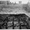
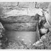
Excavations have revealed remains of four successive timber bridges crossing the moat. Little of the S range of the castle remains, but elsewhere the building is, at least externally, mainly entire to the wallhead.
S Cruden 1956; 1959; 1960; 1963; J G Dunbar 1966; N Tranter 1970; A E Truckell and J Williams 1967
This castle is as described and illustrated by the previous authorities.
Visited by OS (EGC) 18 August 1965
3 fragments of medieval Pottery found while excavating in Caerlaverock Castle, Dumfriesshire, 18 years ago. Factor Lord Herries.
J Williams 1975.
NY 0255 6560 Excavation of a trial pit prior to the creation of a soakaway was monitored in October 1999. The trial pit was located in the W corner of the field to the E of the Guardianship area, and was up to 2.5m in depth.
The excavations indicated that the surface scarp noted in the field is the line of a raised beach. No deposits of archaeological significance were disturbed.
The subsequent programme of drainage improvements was carried out in late February 2000, again with archaeological monitoring. These works involved the machine-excavation of a trench 58m long with a depth ranging from 300-950mm.
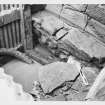
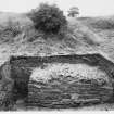
In the area to the N of the car park excavations revealed a complex area of cobbling, demolished walls and late cuts. Examination of this group of features suggested the existence of a cobbled surface, complete with central surface drain, with a width E-W of almost 10m. The surface appeared to be bounded to the E and W by roughly built red sandstone walls, with the possible existence of a central wall just W of the surface drain. The cobbles were sealed by up to 500mm of demolition debris, mounded up in the E and centre of the structure, and lensing out to the E and W. A late drain appeared to be cut into the position of the E wall, while a wide depression-like cut filled with debris and redeposited natural lay over the W wall. The whole was sealed with between 100-250mm of topsoil.
There is clearly a substantial structure existing to the S of the cottages adjacent to the entrance archway which may have been partly removed by the new car park. The structure appears to be a large cobbled compound of some sort, aligned N-S, which may have had a perimeter wall and been unroofed. No slates or tiles were found in the demolition debris covering the floor levels. The surface drain seems to indicate that livestock may have been housed within the structure.
Sponsor: Historic Scotland
D Stewart and P Sharman 2000
NY 025 656 Monitoring works at Caerlaverock Castle comprised the excavation of soakaway trenches in the grazed pasture field to the W of the Guardianship area, WSW of the visitor centre, and a hole for a septic tank to the SW of the toilet block. The monitoring of the soakaway trenches was undertaken on several visits during October, November and December 2001, and the excavation of the pit for the septic tank was monitored in January 2001.
This part of the Guardianship area has been used for dumping debris as well as for the creation of the car park. However, this material appears mostly to have sealed the surviving archaeology rather than destroying it, although it did stop the geophysical surveys from picking up the remains. The ditch cut also shows that archaeology survives below the pasture, despite it having been ploughed in the past. These are encouraging results for the survival of medieval remains in a superficially unpromising part of the monument.
A watching brief was also undertaken in the woods to the S of Caerlaverock Castle while trees were felled. There was no significant damage to the earthworks. The features recorded show that the earthworks in the wooded area of the Caerlaverock Estate are more complex and extensive than usually depicted. It may be possible, with further work, to identify which features are associated with the old castle, with the sieges, with water catchment and with later estate management, potentially including the use of the grounds as romantic pleasure gardens.
Archive to be deposited in the NMRS.
Sponsor: HS
G Ewart and P Sharman 2002.
NY 025 656 Archaeological monitoring was undertaken in August 2004 while contractors hand-dug a telephone cable trench in the field to the N of the monument. Nothing of archaeological significance was seen in this long slit trench.
Archive to be deposited in the NMRS.
Sponsor: HS.
D Stewart 2004
NY 0252 6582 Archaeological monitoring was undertaken in November 2004 while a post-hole was dug in the field to the N of the monument within the Guardianship area of Caerlaverock Castle (NY06NW 6). Nothing of archaeological significance was seen.
Archive to be deposited in NMRS.
Sponsor: HS
D Stewart 2005
NY 025 656 Reconnaissance coring of the sediments of the moat systems of Caerlaverock New Castle. The results of sediment coring within the outer moat are that the highly organic pond and peat sediments infilling the outer moat are interrupted by distinctive inwashed bands of grey minerogenic silty clays and clays. These are recorded up to 8.5 m OD. The data provisionally suggest that the outer moat may have been impacted by extreme marine flood events that were to at least this altitude, in the same way that the moat system at the Old Castle had been inundated. This interpretation remains tentative until definitive sediment- and bio-stratigraphic analyses can confirm the marine origin of the minerogenic sediments, but if confirmed would represent evidence for the most exceptional Medieval and post-Medieval marine inundation of all of the lower Lochar Valley.
R Tipping 2004
NY 025 656 Archaeological monitoring was undertaken during the digging of five trenches to establish the nature of the ground make-up to the N of the castle. This work was carried out in June 2006 in advance of the potential installation of a new drainage system. New drains were considered necessary since sustained periods of rain had been seen to leave areas waterlogged.
This trenching activity allowed a profile to be established in the proposed route of future drainage, and that there is a variation in the ground make-up from natural deposits to various road phases to modern landscaping. Partially revealed, unmortared masonry may be a reduced field wall. There were no other finds or features of archaeological significance.
Archive to be deposited in NMRS.
Sponsor: Historic Scotland
Paul Fox and Thom Walley, 2006.
NY 025 656 Archaeological monitoring was undertaken in August 2006 during the digging of five small trenches to hold the poured-concrete foundations of new information boards. There were no finds or features of archaeological significance.
Archive to be deposited in NMRS.
Sponsor: Historic Scotland
Angus Mackintosh, 2006.
NY 025 656 Archaeological monitoring was undertaken between 16-26 October 2006 while sub-contractors undertook
the excavation of two soakaways and two drainage channels alongside the current road and SE car parks. An additional day of monitoring was required during the removal of the road's subbase over a 56.4m section. During these works a field drain and wall were partially revealed. Neither feature was thought to be earlier than 18th-century in date.
Archive to be deposited with RCAHMS.
Funder: Historic Scotland.
Sarah Hogg, 2007.
NY 024 657 Archaeological monitoring was undertaken on 21 November 2006 during the excavation of a trench near the
visitor centre as part of works to replace an existing underground electricity cable. The works caused no disturbance to any previously undisturbed ground, and the trench ran through an area of much recent disturbance and landscaping. There were no finds or features of archaeological significance.
Archive to be deposited with RCAHMS.
Funder: Historic Scotland.
David Murray, 2007.
NY 025 656 A probable hoard of two EBA bronze axeheads, found in 1976 but not formally allocated to a museum service
at the time, was finally claimed as treasure trove in 2006 and allocated to Dumfries and Galloway Museums (Dumfries) (TT 94/06). Although published (Yates 1979), this discovery was too late for inclusion in Schmidt and Burgess's corpus of Bronze Age axes from Scotland and northern England (1981). In terms of their typology, the smaller axehead falls within the range of Migdale type axes, although its outline may have been modified by reworking and that it may originally have been larger. The larger axehead can be compared most closely in terms of overall shape, if not exact size, with axes of the Biggar variant of the Migdale type or among some decorated Migdale axes. In the light of these features, the hoard is likely to date to the later part of the Brithdir stage (2150-2000 BC) in Rohl and Needham's scheme outlining developments in Early Bronze Age.
T Cowie, 2007.
Aerial Photography (1972)
Oblique aerial photographs of Caerlaverock Castle taken by Mr John Dewar in 1972.
Artefact Recovery (1976)
NY 025 656 A probable hoard of two EBA bronze axeheads, found in 1976 but not formally allocated to a museum service at the time, was finally claimed as treasure trove in 2006 and allocated to Dumfries and Galloway Museums (Dumfries) (TT 94/06). Although published (Yates 1979), this discovery was too late for inclusion in Schmidt and Burgess's corpus of Bronze Age axes from Scotland and northern England (1981). In terms of their typology, the smaller axehead falls within the range of Migdale type axes, although its outline may have been modified by reworking and that it may originally have been larger. The larger axehead can be compared most closely in terms of overall shape, if not exact size, with axes of the Biggar variant of the Migdale type or among some decorated Migdale axes. In the light of these features, the hoard is likely to date to the later part of the Brithdir stage (2150-2000 BC) in Rohl and Needham's scheme outlining developments in Early Bronze Age.
T Cowie 2007
Publication Account (1986)
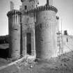
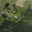
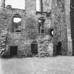
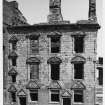
Caerlaverock is, without doubt, the region's premier castle. Its appearance in dazzling red sandstone conveys an impression both of solid strength and dignifIed splendour. The double-towered gatehouse and triangular layout, surrounded by a water-fIlled moat and earthen rampart, display some of the changes in design that were induced partly by Edward I's castle-building activities in the last quarter of the 13th century. Caerlaverock itself is of late 13th century origin, but, curiously, we know neither the identity nor even the nationality of its builder.
By 1300 the castle housed a Scots garrison which harassed English-held Lochmaben (no. 42). Accordingly, in that year, Edward I went out of his way to take Caerlaverock, a siege operation recorded by the author of a contemporary Anglo-Norman ballad. To him, 'Caerlaverock was so strong a castle that it feared no siege before the King came there . . . In shape it was like a shield, for it had but three sides round it, with a tower at each corner, but one of them was a double one, so high, so long, and so wide, that the gate was underneath it, well made and strong, with a drawbridge and a suffIciency of other defences. And it had good walls, and good ditches filled right up to the brim with water .. .'
The singular shape of the castle, unique in Britain, is recognisable in this description. Much of the original masonry is still discernible, particularly in the western curtain-wall and gatehouse-tower, although Caerlaverock suffered badly in the course of later Anglo-Scottish warfare. But just how far the 'destructions' wrought in about 1312 (by the Scots) and 1356-7 (by the English) rendered the castle unusable, and how much rebuilding was undertaken in the 14th century are difficult questions to answer. It is clear that the defences of the castle were restored and improved in the 15th and 16th centuries by the Lords Maxwell, whose armorial is carved above the main gateway. The curtain-walls and eastern gatehouse-tower were reconstructed, and additions were made to the gatehouse itself; the wide-mouthed gun-ports were probably inserted when repairs were in hand in 1593. The castle was among those 'thrown down' by an English army in 1570, palpably an overstatement, whereas the effects of the final episode in the active use of the castle cannot be gainsaid. In 1640 a Royalist garrison under Robert Maxwell, 1st Lord Nithsdale, capitulated after a 13-week siege and bombardment by an army of the Estates, the castle thereafter being partly dismantled to prevent its further occupation.
The vigorous history of this frontier castle satisfyingly bears out its martial appearance, but it was a residence as well as a stronghold. Originally the main hall was on the first floor of the gatehouse block, but was later sub-divided. The 15th century range on the western side of the courtyard contains a series of chambers, probably for guest accommodation. Little survives of the hall block built along the inside of the south curtain in the 1630s, although its doorway gives some idea of its former grandeur. The three-storeyed east range, Nithsdale's building (1634), had a symmetrical six-bay ashlar facade, of which four bays survive intact; the openings have moulded surrounds and carved pediments bearing armorials and relief sculptures. The service basement, which incorporates the castle well, is of early origin; the upper floors were served by a spacious staircase, and most rooms were well equipped with windows, latrines, and fireplaces.
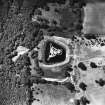
The splendours of Caerlaverock divert attention from the peculiarity of its low-lying setting, close to the edge of woodland swamps and overlooked from the north. An English report of 1563-6 was sceptical of its capabilities 'unless the hill above the same, called the Ward Law, be fortified . . :. However, it had some advantages insofar as 'boats ... often tons will come to the foot of this hill at the full sea'. Among the trees and swamps some 180m to the south of the castle is one of the great unsolved mysteries of Caerlaverock: a large, oblong, and formerly moated platform which has revealed traces of medieval masonry (NX 027656). It may have been a temporary substitute for the existing castle during an alleged phase of dereliction in the 14th century, or a 'failed' 13th century precursor, or even a near-contemporary bridge-head or supply depot. Immediately after the fall of Caerlaverock in 1300, Edward I reconstructed the peel at Dumfries on a large scale, involving the import and trans-shipment of much Cumbrian timber; it is possible that this structure at Caerlaverock may also belong to the English period between 1300 and 1312.
Information from ‘Exploring Scotland’s Heritage: Dumfries and Galloway’, (1986).
Artefact Recovery (19 November 1996 - 20 November 1996)
Kirkdale Archaeology Ltd, under contract with Historic Scotland, were commissioned to retrieve for dating purposes certain pieces of timber uncovered in previous excavations. The wood was to be taken, if possible, from 2 places, the first being a box-like structure or sump lined with planks discovered during the 1959 excavations (pit 3) in the moat at the junction between the S curtain wall and the SE tower. The other timber was to be retrieved from the remnants of a wooden bridge across the outer “dry” moat, excavated in 1966. The work was carried out on the 19th and 20th November 1996 and recorded using photography, notes and a location plan imposed on a copy of the location plan for the previous excavations.
Kirkdale Archaeology Ltd, 1996
Excavation (10 November 1999)
Excavation of a trial pit prior to the creation of a soakaway was monitored in October 1999. The trial pit was located in the W corner of the field to the E of the Guardianship area, and was up to 2.5m in depth.
The excavations indicated that the surface scarp noted in the field is the line of a raised beach. No deposits of archaeological significance were disturbed.
The subsequent programme of drainage improvements was carried out in late February 2000, again with archaeological monitoring. These works involved the machine-excavation of a trench 58m long with a depth ranging from 300-950mm.
In the area to the N of the car park excavations revealed a complex area of cobbling, demolished walls and late cuts. Examination of this group of features suggested the existence of a cobbled surface, complete with central surface drain, with a width E-W of almost 10m. The surface appeared to be bounded to the E and W by roughly built red sandstone walls, with the possible existence of a central wall just W of the surface drain. The cobbles were sealed by up to 500mm of demolition debris, mounded up in the E and centre of the structure, and lensing out to the E and W. A late drain appeared to be cut into the position of the E wall, while a wide depression-like cut filled with debris and redeposited natural lay over the W wall. The whole was sealed with between 100-250mm of topsoil.
There is clearly a substantial structure existing to the S of the cottages adjacent to the entrance archway which may have been partly removed by the new car park. The structure appears to be a large cobbled compound of some sort, aligned N-S, which may have had a perimeter wall and been unroofed. No slates or tiles were found in the demolition debris covering the floor levels. The surface drain seems to indicate that livestock may have been housed within the structure.
Sponsor: Historic Scotland
D Stewart and P Sharman
Kirkdale Archaeology
Watching Brief (21 February 2000 - 25 February 2000)
A programme of drainage improvements was carried out in late February 2000 at Caerlaverock Castle, Dumfriesshire, in order to counteract the constant flooding of the castle car park. These works involved the machine-excavation of a trench 58m long with a depth ranging from 300-950mm.
In the area to the N of the car park excavations revealed a complex area of cobbling, demolished walls and late cuts. Examination of this group of features suggested the existence of a cobbled surface, complete with central surface drain, with a width E-W of almost 10m. The surface appeared to be bounded to the E and W by roughly built red sandstone walls, with the possible existence of a central wall just W of the surface drain. The cobbles were sealed by up to 500mm of demolition debris, mounded up in the E and centre of the structure, and lensing out to the E and W. A late drain appeared to be cut into the position of the E wall, while a wide depression-like cut filled with debris and redeposited natural lay over the W wall. The whole was sealed with between 100-250mm of topsoil.
There is clearly a substantial structure existing to the S of the cottages adjacent to the entrance archway which may have been partly removed by the new car park. The structure appears to be a large cobbled compound of some sort, aligned N-S, which may have had a perimeter wall and been unroofed. No slates or tiles were found in the demolition debris covering the floor levels. The surface drain seems to indicate that livestock may have been housed within the structure.
Sponsor: Historic Scotland
D Stewart and P Sharman 2000
Kirkdale Archaeology
Watching Brief (19 September 2000)
A watching brief was conducted in September 2000 during the excavation of two test pits for soakaway holes in a field to the NW of Caerlaverock Castle, Dumfries and Galloway (NGR NY 025 656). Nothing of archaeological significance was disturbed.
Sponsor: Historic Scotland
G Ewart & P Sharman 2000
Kirkdale Archaeology
Excavation (7 January 2002 - 17 January 2002)
NY 025 656 Monitoring works at Caerlaverock Castle comprised the excavation of soakaway trenches in the grazed pasture field to the W of the Guardianship area, WSW of the visitor centre, and a hole for a septic tank to the SW of the toilet block. The monitoring of the soakaway trenches was under taken on several visits during October, November and December 2001, and the excavation of the pit for the septic tank was monitored in January 2002.
G Ewart and P Sharman 2002
Sponsor: Historic Scotland
Kirkdale Archaeology
Watching Brief (2 August 2004 - 4 August 2004)
NY 025 656 Archaeological monitoring was undertaken in August 2004 while contractors hand-dug a telephone cable trench in the field to the N of the monument. Nothing of archaeological significance was seen in this long slit trench.
D Stewart 2004
Sponsor: Historic Scotland
Kirkdale Archaeology
Excavation (15 August 2006)
Under the terms of its PIC call‐off contract with Historic Scotland, Kirkdale Archaeology was asked to undertake archaeological monitoring at Caerlaverock Castle while HS MCU personnel undertook the excavation of five small trenches to hold the poured‐concrete foundations of new information boards.
A Mackintosh 2006
Sponsor: Historic Scotland
Kirkdale Archaeology
Excavation (28 June 2006 - 29 June 2006)
Under the terms of its PIC call-off contract with Historic Scotland, Kirkdale Archaeology was asked to undertake archaeological monitoring at Caerlaverock Castle, near Dumfries, while HS MCU personnel undertook the digging of five trenches to establish the nature of the ground make-up to the N of the castle. This work was carried out in advance of the potential installation of a new drainage system. New drains were considered necessary since sustained periods of rain had been seen to leave areas waterlogged.
This trenching activity has allowed a profile to be established across the area of ground to the N of the Castle in the proposed route of future drainage. This has established that there is a variation in the ground make up from natural deposits to various road phases to modern landscaping. Wall line 2005 may be a reduced field wall as it is unmortared and would require further excavation ahead of any future groundbreaking activity at this depth.
P Fox and T Whalley 2006
Sponsor: Historic Scotland
Kirkdale Archaeology
Watching Brief (21 November 2006)
NY 024 657 Archaeological monitoring was undertaken on 21 November 2006 during the excavation of a trench near the visitor centre as part of works to replace an existing underground electricity cable. The works caused no disturbance to any previously undisturbed ground, and the trench ran through an area of much recent disturbance and landscaping. There were no finds or features of archaeological significance.
D Murray 2006
Sponsor: Historic Scotland
Kirkdale Archaeology
Watching Brief (16 October 2006 - 26 October 2006)
Under the terms of its PIC call‐off contract with Historic Scotland, Kirkdale Archaeology was asked to undertake archaeological monitoring at Caerlaverock Castle while sub‐contractors undertook the excavation of two soakaways and two drainage channels alongside the current road and SE car parks. An additional day of monitoring was required during the removal of the sub‐base over a 56.4 m section of the current road. The work was necessary because the current SE car parks slope away from the road surface in such a way that water draining from the road gathers at the back of the car parks, also causing an accumulation of soil and leaves. The water does not drain freely resulting in boggy ground unsuitable for parking. The drainage channel (Trench 2) and soakaway (Trench 1) on the W side of the current road were intended to work in conjunction with a new road surface cambered to the W, to drain surface water away from the car parks. The drainage channel (Trench 4) and soakaway (Trench 3) to the E of the car parks will drain any remaining water from back of the car parks.
S Hogg 2006
Sponsor: Historic Scotland
Kirkdale Archaeology
OASIS ID: kirkdale1-249626
Fabric Recording (December 2007 - January 2008)
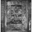
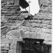
NY 0254 6563 This small collection of late and post-medieval stones, mostly in the striking red sandstone of the area, was assessed during December 2007–January 2008. It contains a number of impressive carvings. Many of the stones are substantial and include window pediments and heraldic panels. A fine example of Maxwell heraldry is on display in the castle’s museum. It shows a two-headed eagle with outstretched wings, and a small shield with a saltire. The damaged feature on the right-hand side of the shield is a stag, and one cloven hoof is still clearly visible. Another striking piece is the large gargoyle on display in the visitor tea room. The grimacing face is shown with lines around the eyes, nose and mouth, emphasizing the expression, and the teeth, Adam’s apple and wispy beard are given detailed treatment. The lack of weathering on the stone indicates that it originally came from an indoor location, for example the W range.
This and other inventories of carved stones at Historic Scotland’s properties in care are held by Historic Scotland’s Collections Unit. For further information go to: hs.collections@scotland.gsi.gov.uk.
Funder: Historic Scotland
Mary Markus, 2008
Excavation (8 February 2007)
Under the terms of its PIC call‐off contract with Historic Scotland, Kirkdale Archaeology was asked to undertake a short period of archaeological monitoring at Caerlaverock Castle during the extension of a drain in the N car park. The excavation was carried out by contractors.
The drain originally had been excavated in October 2006 (under archaeological supervision) to direct surface water away from the Golpla‐surfaced car parks to the NE of the castle but following three months of use there remained a build up of water in the SE corner of the N car park. From previous excavations carried out by Kirkdale Archaeology in June 2006 and a watching brief in October 2006 it was known that there is an 18th‐ or 19th‐century wall in this area, therefore the excavation was carried by hand when the area in which the wall was known to be located.
The excavation of the drain extension in the SE corner of the N car park revealed a previously excavated wall, probably dating to the 18th‐ or 19th‐century. There were no visible remains of this structure above ground, possibly due in part to the car park landscaping. Though relatively little of the wall was revealed during the current excavation the build of small, roughly rectangular blocks including bricks appeared fairly crude, suggesting that this structure may have been an outbuilding for one of the cottages at one time, which then fell into disuse and was demolished.
G Ewart 2007
Sponsor: Historic Scotland
Kirkdale Archaeology
Excavation (7 April 2008 - 8 May 2008)
NY 025 656 The hand excavation of an electricity cable trench was undertaken from 7 April–8 May 2008 in the grounds of the castle. A total of 285m was excavated of which c140m was inside the scheduled area. A small section of post-medieval wall was uncovered near the current Greenhead Cottages. The wall, which was two courses high, was constructed directly on top of the natural bedrock, which had been cut to form terrace-like steps. A probable return was located but it appeared the stone here had been robbed away. This robbed-out return also appeared to be the terminus of the wall, but the narrowness of the trench prevented any further to investigation. Although the main wall appeared to be running to the south-eastern corner of the existing cottages it was on a slightly more northerly alignment than the cottage wall. The finds from the fill of the cut for the wall indicate a later postmedieval date. A lead cannonball was recovered from a layer just to the SW of the current stone gate. It measured 45mm in diameter and weighed 630g. Several sherds of medieval pottery were recovered from the trench along with a silver George III half crown dating to 1819.
Archive: Historic Scotland. Report: Dumfries and Galloway SMR, RCAHMS and Historic Scotland
Funder: Scottish Power
David Sneddon (GUARD), 2008
Watching Brief (18 February 2009)
NY 025 658 A watching brief was carried out on 18 March 2009 during the excavation of six small and four larger test pits in the field to the N of the visitor centre. The pits were positioned to avoid possible features identified during a previous geophysical survey. Deposits of uncertain date containing a fragment of modern china and a chert flake lay between the plough soil and the underlying natural. As the plough soil did not reach the subsoil archaeological features may survive beneath this modern horizon. The chert flake, although probably redeposited is a reminder of the potential for early sites along a relic coastline.
Archive: RCAHMS (intended)
Funder: Historic Scotland
David Murray – Kirkdale Archaeology
Watching Brief (14 April 2010)
NY 0244 6556 A watching brief was undertaken on 14 April 2010 during the replacement of visitor direction signs and interpretation boards. A layer of redeposited yellow boulder clay was observed just beneath the turf line. This may date from the construction of the moat in the 13th century, and therefore may seal a medieval ground surface.
P Fox and D Gorman 2010
Sponsor: Historic Scotland
Kirkdale Archaeology
OASIS Id: kirkdale1-249879
Watching Brief (15 November 2010 - 17 November 2010)
NY 0248 6576, NY 0252 6570 and NY 0253 6566 A watching brief was maintained 15–17 November 2010 during the excavation of three small trenches that were dug in order to locate a fault in a power cable. Only one trench revealed any deposits of archaeological interest (NY 0253 6566). These deposits included possible construction debris, an earlier ground surface and gravel layers, which may have related to the excavation and re-deposition of natural deposits during the construction of the castle moat.
Archive: RCAHMS (intended)
Funder: Historic Scotland
Kirkdale Archaeology 2010
Excavation (25 February 2011 - 8 March 2011)
In preparation for the large scale excavation of the new car park in late March and early April Kirkdale Archaeology excavated a series of test trenches in the vicinity of the proposed area.
G Ewart 2011
Sponsor: Historic Scotland
Kirkdale Archaeology
Excavation (28 March 2011 - 7 April 2011)
NY 0244 6583 (centred on) A series of trenches was excavated 28 March–7 April 2011 in a field to the N of the visitor centre to assess the potential impact of a new car park. The trench locations were guided by an earlier geophysical survey. In addition to a modern service trench, a number of archaeological features were recorded. These consisted of a combination of linear slots and ditch-like features plus a series of discrete pits of various sizes. Archaeological features were located in all of the trenches. Only one of these features was fully excavated, the rest being revealed after the machine removal of topsoil. The features revealed towards the S edge of the site were generally more extensive and better preserved than those towards the N of the site, where the plough soil was shallower. The features are thought to mainly represent prehistoric activity across the whole site. A ditch and pit complex, noted in Trench 9, was partly excavated and prehistoric pottery was retrieved from the pit, with part of an edge of pottery also recorded in the ditch. The upper fill of the southern of two ditches in Trench 5 was partly excavated, exposing an underlying stone-rich fill.
Archive: RCAHMS (intended)
Funder: Historic Scotland
Kirkdale Archaeology 2011
Information also reported in Oasis (kirkdale1-122353) 2 April 2013
Magnetometry (14 December 2017 - 15 December 2017)
NY 02548 65638 A geophysical survey was undertaken, 14 – 15 December 2017, in a pasture field to the NW of the castle. Aerial photographs (APs) of the area show numerous cropmarks suggesting prehistoric features within the field and extending to the N. Previous excavation to the E revealed extensive archaeological remains.
The survey of the entire c4.9ha field with a fluxgate gradiometer aimed to determine the presence / confirm the location of any archaeological features prior to the potential creation of a car park. A well-defined enclosure and associated ditch-type anomaly were detected in the E of the survey area and shows good correlation with AP features. Additional short ditch-type anomalies, consistent with the AP transcription, were also detected, although some elements indicated on the AP transcriptions were not visible within the data. Some very weak anomalies were also noted which may be of archaeological interest, although such an interpretation is cautious. However, the data does not suggest a significant complex of features beyond what is visible in the APs.
Archive: Rose Geophysical Consultants
Funder: CFA Archaeology on behalf of HES
Susan Ovenden – Rose Geophysical Consultants
(Source: DES Vol 19)
Archaeological Evaluation (August 2018)
NY 0236 6573 A 10% trial trenching evaluation was carried out, August 2018, in advance of development. The 21 trenches established that archaeological remains are widespread across the site. Few artefacts were found in primary contexts and those recovered mainly dated to medieval and post-medieval periods.
Archive: NRHE (intended). Report: Dumfries and Galloway HER
Funder: Historic Environment Scotland
Ian Suddaby – CFA Archaeology Ltd
(Source: DES Vol 19)
Watching Brief (July 2018)
NY 0261 6549 A watching brief was carried out, July 2018, at Castle Wood between Old and New Caelaverock Castle, during the recovery of a geotechnical core extracted from a borehole close to the proposed location of a new boardwalk. The core attained a maximum depth of 3.6m below the present ground surface and contained five biostratigraphical units. The most dominant units were 3 and 4, and these were comprised of a deep deposit of marine (Carse) clay which was locally extensive. This deposit overlay breccia bedrock comprised of fractured rock and gravel. The carse clay (classified as the New Castle Surface) relates to the Main Postglacial Transgression of high sea level, the onset of which is dated to c6590 ± 65 14C BP and culminated at about 4000 14C BP.
Archive: NRHE (intended). Report: Dumfries and Galloway HER
Funder: Historic Environment Scotland
Mike Cressey – CFA Archaeology Ltd
(Source: DES Vol 19)
OASIS ID: cfaarcha1-326113
Field Visit (March 2018)
NY 02537 65469 A walkover survey of Castle Wood at Caerlaverock was undertaken, March 2018, complemented by historic map research. Castle Wood encompasses both the ‘old’ and ‘new’ castle remains and most of their surrounding earthworks, and forms a sub-rectangular block c1km wide. A LiDAR survey by HES revealed a complex palimpsest of old enclosures and field boundaries beneath the tree canopy, and helped us to sub-divide the wood into compartments for the purposes of the assessment. The objective of the work was to enhance the understanding of the property in care’s (PIC182) relationship with the surrounding wooded landscape.
The Maxwell’s built the ‘old’ castle around 1220; it was abandoned around 1270 when the ‘new’ castle was built, and the area is believed to have been wooded then too, based on pollen evidence. This ‘new’ castle continued to be developed into the early 17th century until a siege in 1640 rendered it a ruin. The first castle is beside an old harbour, thought to be contemporary with it, and showing how the shoreline has gradually shifted several hundred metres further S since then.
Based on the survey evidence, our working hypothesis is that small patches of early woodland survive at Caerlaverock, often on old boundary features, overlain by a much wider patchwork of improvement period oak plantings (mostly subsequently coppiced), interspersed with semi-natural wet woodlands and modern plantations. The improvement era planting of oak followed the drier upstanding old boundaries and the better drained open areas, some of them probably fields in medieval times, while wet alder-dominated woodland persisted in the lower wetter areas in between. New improvement era drains and enclosing banks were also created, evidence of continued economic investment in this wood after occupation of the castle ceased. The majority of oaks were coppiced, the last cut probably being in the early 19th century based on approximate ring counts of a couple of fallen stems.
Despite the still-functioning improvement drainage system, much of the woodland is very wet today, making for a rich biodiverse ecosystem and also likely to promote good organic survival of archaeological remains. While coppiced oak is most common, the rarer pollard and maiden forms of oak on some of the boundaries are likely to be rather older, for example on the bank of the bailey to the E of the old castle. A number of skirted old oaks indicate historic grazing pressure, and 18th-century mapping, the earliest to show any detail, shows a wood with a number of open meadow areas within. However, we found no obvious evidence of there being a deer park here. The form of a substantial curved dyke just W of the old castle, on which many oak coppice stools have grown, was more suggestive of a former sea wall than a park dyke.
Archive: NRHE (intended). Report: Dumfries and Galloway HER
Funder: Historic Environment Scotland
Coralie Mills and Peter Quelch – Dendrochronicle for CFA Archaeology Ltd
(Source: DES Vol 19)

