
Scheduled Maintenance
Please be advised that this website will undergo scheduled maintenance on the following dates: •
Tuesday 3rd December 11:00-15:00
During these times, some services may be temporarily unavailable. We apologise for any inconvenience this may cause.
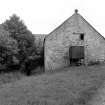
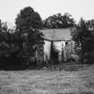
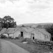
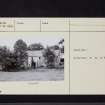
Snade Mill


Watermill (18th Century)
Site Name Snade Mill
Classification Watermill (18th Century)
Alternative Name(s) Cairn Water
Canmore ID 65102
Site Number NX88NW 22
NGR NX 84573 87080
Datum OSGB36 - NGR
Permalink http://canmore.org.uk/site/65102


- Council Dumfries And Galloway
- Parish Glencairn
- Former Region Dumfries And Galloway
- Former District Nithsdale
- Former County Dumfries-shire
NX88NW 22.00 84573 87080
Snade Mill
(disused) [NAT]
OS (GIS) MasterMap, August 2009.
NX88NW 22.01 NX 84422 87149 to NX 84429 87130 to NX 84512 87141 to NX 84547 87158 Caul (Weir)
NX88NW 22.02 NX 84548 87155 to NX 84577 87081 Lade
NX88NW 22.03 NX 84577 87081 Sluice
For footbridge to E (at NX 84613 87211), see NX88NW 24.
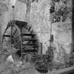
An 18th century corn mill in working order with a water wheel.
SDD List [undated].
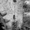
(Location cited as NX 846 871). Snade Mill, late 18th to early 19th century. A two-storey rubble building on an L plan, with a six-spoke, low-breast wood and iron paddle-wheel, 3ft 9ins (1.14m) wide by 16ft (4.88m) diameter. One pair of stones is still in position, and there is an unusual geared sluice-operating system.
J R Hume 1976.
The mill lade, mill building, wheel and internal workings are all int act and in working order.
Visited by OS 26 August 1977.

