
Green Island, Milton Loch


Fort (Period Unassigned)
Site Name Green Island, Milton Loch
Classification Fort (Period Unassigned)
Canmore ID 65045
Site Number NX87SW 3
NGR NX 8385 7164
Datum OSGB36 - NGR
Permalink http://canmore.org.uk/site/65045


- Council Dumfries And Galloway
- Parish Urr
- Former Region Dumfries And Galloway
- Former District Stewartry
- Former County Kirkcudbrightshire
NX87SW 3 8385 7164.
(NX 8385 7164) Earthwork (NR)
OS 6" map (1957)
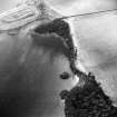
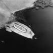
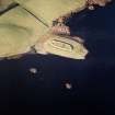
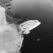
The earthwork (C M Piggott 1955) on Green Island, noted by the RCAHMS as a fort, consists of a narrow boat-shaped area 246' by 73', enclosed by a 3' high rampart and a shallow external ditch 10'-12' wide. There is a short berm between the rampart and ditch. The rampart has almost disappeared in the E. The 8' wide entrance is in the W; it is approached by a roadway carried over the ditch on unexcavated ground. The rampart on either side of the entrance is more massive than elsewhere, and the ditch has squared angles to N and S of it. A narrow gap in the rampart in the N is probably secondary. In the extreme NW angle of the ditch, adjacent to the entrance is a water-hole, while in the interior opposite the entrance is a small oblong depression, possibly a well.
Piggott considers that the work is 'almost certainly of Dark Age or medieval date', while Truckell states it 'seems a definitely Viking type of site.'
RCAHMS 1914, visited 1912; C M Piggott 1955; A E Truckell 1963
An earthwork generally as described. The date and purpose of this work cannot be determined but its situation and construction are not typical of a fort. Mr Truckell, of Dumfries Museum, now believes it to be Medieval.
Resurveyed at 1/2500.
Visited by OS (BS) 6 November 1973.
Field Visit (21 May 1951)
This site was included within the RCAHMS Marginal Land Survey (1950-1962), an unpublished rescue project. Site descriptions, organised by county, are available to view online - see the searchable PDF in 'Digital Items'. These vary from short notes, to lengthy and full descriptions. Contemporary plane-table surveys and inked drawings, where available, can be viewed online in most cases - see 'Digital Images'. The original typecripts, notebooks and drawings can also be viewed in the RCAHMS search room.
Information from RCAHMS (GFG) 19 July 2013.
Note (20 December 2013 - 23 May 2016)
This curious and undated earthwork cannot be classified as a fort as such, but occupying the crest of a promontory jutting out into Milton Loch it evidently retains some measure of defence in its perimeter. An elongated oval on plan, it measures 72m from E to W by 18m transversely (0.12ha) within a bank standing 0.9m high internally and 2.7m externally above the bottom of a concentric ditch, from which it is separated by a narrow berm. The ditch itself appears relatively shallow and is generally some 3.5m broad, but at the W end, where the bank is also more substantial, the counterscarp of the ditch splays outwards to form broad squared terminals facing onto the isthmus on the W to either side of a centrally placed entrance causeway. A second gap in the bank on the N is probably relatively modern.
Information from An Atlas of Hillforts of Great Britain and Ireland – 23 May 2016. Atlas of Hillforts SC0319

