
Following the launch of trove.scot in February 2025 we are now planning the retiral of some of our webservices. Canmore will be switched off on 24th June 2025. Information about the closure can be found on the HES website: Retiral of HES web services | Historic Environment Scotland
Green Island, Milton Loch


Fort (Period Unassigned)
Site Name Green Island, Milton Loch
Classification Fort (Period Unassigned)
Canmore ID 65045
Site Number NX87SW 3
NGR NX 8385 7164
Datum OSGB36 - NGR
Permalink http://canmore.org.uk/site/65045


- Council Dumfries And Galloway
- Parish Urr
- Former Region Dumfries And Galloway
- Former District Stewartry
- Former County Kirkcudbrightshire
NX87SW 3 8385 7164.
(NX 8385 7164) Earthwork (NR)
OS 6" map (1957)
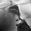
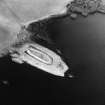
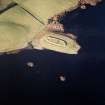
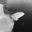
The earthwork (C M Piggott 1955) on Green Island, noted by the RCAHMS as a fort, consists of a narrow boat-shaped area 246' by 73', enclosed by a 3' high rampart and a shallow external ditch 10'-12' wide. There is a short berm between the rampart and ditch. The rampart has almost disappeared in the E. The 8' wide entrance is in the W; it is approached by a roadway carried over the ditch on unexcavated ground. The rampart on either side of the entrance is more massive than elsewhere, and the ditch has squared angles to N and S of it. A narrow gap in the rampart in the N is probably secondary. In the extreme NW angle of the ditch, adjacent to the entrance is a water-hole, while in the interior opposite the entrance is a small oblong depression, possibly a well.
Piggott considers that the work is 'almost certainly of Dark Age or medieval date', while Truckell states it 'seems a definitely Viking type of site.'
RCAHMS 1914, visited 1912; C M Piggott 1955; A E Truckell 1963
An earthwork generally as described. The date and purpose of this work cannot be determined but its situation and construction are not typical of a fort. Mr Truckell, of Dumfries Museum, now believes it to be Medieval.
Resurveyed at 1/2500.
Visited by OS (BS) 6 November 1973.
Field Visit (21 May 1951)
This site was included within the RCAHMS Marginal Land Survey (1950-1962), an unpublished rescue project. Site descriptions, organised by county, are available to view online - see the searchable PDF in 'Digital Items'. These vary from short notes, to lengthy and full descriptions. Contemporary plane-table surveys and inked drawings, where available, can be viewed online in most cases - see 'Digital Images'. The original typecripts, notebooks and drawings can also be viewed in the RCAHMS search room.
Information from RCAHMS (GFG) 19 July 2013.
Note (20 December 2013 - 23 May 2016)
This curious and undated earthwork cannot be classified as a fort as such, but occupying the crest of a promontory jutting out into Milton Loch it evidently retains some measure of defence in its perimeter. An elongated oval on plan, it measures 72m from E to W by 18m transversely (0.12ha) within a bank standing 0.9m high internally and 2.7m externally above the bottom of a concentric ditch, from which it is separated by a narrow berm. The ditch itself appears relatively shallow and is generally some 3.5m broad, but at the W end, where the bank is also more substantial, the counterscarp of the ditch splays outwards to form broad squared terminals facing onto the isthmus on the W to either side of a centrally placed entrance causeway. A second gap in the bank on the N is probably relatively modern.
Information from An Atlas of Hillforts of Great Britain and Ireland – 23 May 2016. Atlas of Hillforts SC0319

