
Innermessan Mote


Motte (Medieval)
Site Name Innermessan Mote
Classification Motte (Medieval)
Canmore ID 60771
Site Number NX06SE 3
NGR NX 08417 63296
NGR Description Centre
Datum OSGB36 - NGR
Permalink http://canmore.org.uk/site/60771


- Council Dumfries And Galloway
- Parish Inch
- Former Region Dumfries And Galloway
- Former District Wigtown
- Former County Wigtownshire
NX06SE 3 0841 6329
(NX 0841 6329) Innermessan Mote (NR)
OS 6" map (1938)
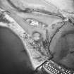
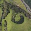
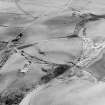
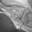
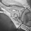
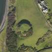
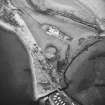
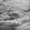
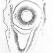
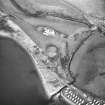
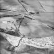
Mote of Innermessan. It rises to a height of above 30 feet above the bottom of the ditch which encircles it. The level top measures some 95 feet East to West by 98 feet north to south and has been surrounded by a low parapet at the edge of the scarp. The ditch has been much reduced by ploughing on the east side but on the seaward it is well preserved. It has been flat-bottomed with a width of 20 to 40 feet and a depth of 6 to 8 feet. The tongue of land to the south is natural.
RCAHMS 1912, visited 1911; R W Feachem 1956; M Harper 1896
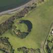
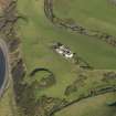
The remains of the motte are generally as described by Harper. It is probable that its flat top was enclosed by a wall or rampart of earth and stones, the scarp of which can be seen on the west side. The short stretch of bank on the south side may be modern. The top and sides of the mound are mutilated, with the remains of several slit-trenches in evidence. On the west side the ditch is being slowly destroyed by erosion.
Revised at 25".
Visited by OS (WDJ) 11 February 1963
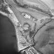
This motte is situated on the raised beach 50m SSW of Innermessan steading. It stands to a height of 12.8m on the SSW and its roughly level summit measures about 29m in diameter. Except on the SE side, where the ground falls steeply, the motte is enclosed by a ditch up to 11m broad and 1m deep. In 1834 excavations on the summit at a depth of about 0.9m 'a stratum consisting of ashes, charred wood and fragments of bone'.
RCAHMS 1987, visited March 1986
Visible on vertical air photographs, (OS 76/143/005-6, flown 1976).
Information from RCAHMS (DE) August 1996
Field Visit (21 June 1911)
Mote, Innermessan.
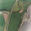
Situated on the end of a high bank skirting the coastline near where it terminates on the N. side of the Glen of the Messan Burn, and about 2 m. NE. of Stranraer, is the Mote of Innermessan (fig. 23). It rises with steeply scarped sides to a height of about 30' above the bottom of the ditch which encircles it. The level top measures some 95' from E. to W. by 98' from N. to S., and has been surrounded by a low parapet at the edge of the scarp. The ditch has been much reduced by ploughing on the E. side, but on the seaward side it is well preserved. It has been flat-bottomed, with a width of from 20' to 40', and a depth of from 6' to 8'. To the S. a tongue of land has been formed naturally, with a gradual fall towards the point of the heugh on the N. side of the glen. Above this is the narrowest portion of the ditch.
O. S.M., WIGTOWN, xi. SE.
Visited 21st June 1911.
Project (10 September 2012 - 15 September 2012)
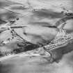
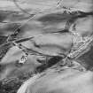
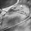
NX 0839 6384 Two extensive community geophysical surveys were carried out 10–15 September 2012 by volunteers as part of a series of events by Discovering Dumfries and Galloway’s Past, run by the University of Glasgow.
The magnetic survey focused on the area to the N of the base of the Motte of Innermessan (NX06SE 3), whilst the resistivity survey focused on a possible field boundary noted on aerial photographs, 350m to the N of Innermessan Farm (NX06SE 98). A number of features were visible in the resistance survey, which probably related to post-medieval agriculture, and the use of this area in WW2, including pipes connected to an extant 1940s water tank. A number of other features, including possible building platforms may relate to earlier activity in this area. The magnetic survey failed to record any traces of features associated with a bailey, but did locate a double-ditched feature, apparently cut by the motte ditch.
Report: Dumfries and Galloway SMR (intended)
Funder: The Scottish Government and The European Community, Dumfries and Galloway LEADER 2007–2013, The Crichton Foundation and The University of Glasgow
Giles Carey, University of Glasgow
2012
Earth Resistance Survey (10 September 2012 - 15 September 2012)
NX 0839 6384 Resistivity survey.
Report: Dumfries and Galloway SMR (intended)
Funder: The Scottish Government and The European Community, Dumfries and Galloway LEADER 2007–2013, The Crichton Foundation and The University of Glasgow
Giles Carey, University of Glasgow
2012
Magnetometry (10 September 2012 - 15 September 2012)
NX 0839 6384 Magnetometry survey.
Report: Dumfries and Galloway SMR (intended)
Funder: The Scottish Government and The European Community, Dumfries and Galloway LEADER 2007–2013, The Crichton Foundation and The University of Glasgow
Giles Carey, University of Glasgow
2012
Note (22 December 2021)
The location, classification and period of this site have been reviewed.

