Pricing Change
New pricing for orders of material from this site will come into place shortly. Charges for supply of digital images, digitisation on demand, prints and licensing will be altered.
Field Visit


Date 21 June 1911
Event ID 1117251
Category Recording
Type Field Visit
Permalink http://canmore.org.uk/event/1117251
Mote, Innermessan.
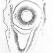
Situated on the end of a high bank skirting the coastline near where it terminates on the N. side of the Glen of the Messan Burn, and about 2 m. NE. of Stranraer, is the Mote of Innermessan (fig. 23). It rises with steeply scarped sides to a height of about 30' above the bottom of the ditch which encircles it. The level top measures some 95' from E. to W. by 98' from N. to S., and has been surrounded by a low parapet at the edge of the scarp. The ditch has been much reduced by ploughing on the E. side, but on the seaward side it is well preserved. It has been flat-bottomed, with a width of from 20' to 40', and a depth of from 6' to 8'. To the S. a tongue of land has been formed naturally, with a gradual fall towards the point of the heugh on the N. side of the glen. Above this is the narrowest portion of the ditch.
O. S.M., WIGTOWN, xi. SE.
Visited 21st June 1911.