
Pricing Change
New pricing for orders of material from this site will come into place shortly. Charges for supply of digital images, digitisation on demand, prints and licensing will be altered.
Achork


Cairn(S) (Prehistoric)
Site Name Achork
Classification Cairn(S) (Prehistoric)
Canmore ID 5998
Site Number NC70SW 41
NGR NC 7479 0459
NGR Description NC 7479 0459 and NC 7476 0452
Datum OSGB36 - NGR
Permalink http://canmore.org.uk/site/5998


- Council Highland
- Parish Rogart
- Former Region Highland
- Former District Sutherland
- Former County Sutherland
Field Visit (10 June 1981)
NC70SW 41 7479 0459 and 7476 0452
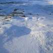
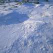
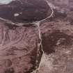
At NC 747 045, in a prominent position in an area of field clearance associated with hut circles (see NC70SW 37) is a group of three small heather covered cairns (A-C) between 3.0m and 4.0m in diameter and up to 0.5m high. These cairns are distinguishable from the numerous stone clearance heaps around them in that they have a regular shape, and are bounded by the remains of a well formed kerb of large stones on edge. Surveyed at 1:10000.
Visited by OS (N K B) 10 June 1981.
Field Visit (21 March 1995)
Only two of the three cairns located in this area by the OS (1981) were visible on the date of survey (A or B and C); this may be due to the deep heather covering the ridge on which the cairns lie. The two cairns identified lie about 75m apart; that to the N (ROG95 422, NC 7479 0459), which is situated on the crest of a rise, is oval on plan and measures 5.4m from N to S by 4.8m transversely over a kerb of boulders standing up to 0.6m high. The S cairn (ROG95 421, NC 7476 0452) lies on the edge of a terrace and measures 4m from NW to SE by 3.5m transversely over a ring of boulders up to 0.4m high. The cairns are situated on the W edge of an area of small cairns that forms part of the site recorded as NC 70SW 42.
(ROG95 421-2)
Visited by RCAHMS (PJD) 21 March 1995

