Following the launch of trove.scot in February 2025 we are now planning the retiral of some of our webservices. Canmore will be switched off on 24th June 2025. Information about the closure can be found on the HES website: Retiral of HES web services | Historic Environment Scotland
RCAHMS Afforestable Land Survey, Rogart


Date March 1995 - July 1995
Event ID 550869
Category Project
Type Project
Permalink http://canmore.org.uk/event/550869
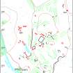
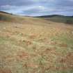
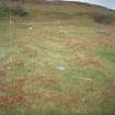
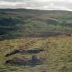
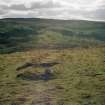
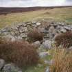
Rogart: fieldwork has been completed in a block of ground covering about 68 square kilometres around the village of Rogart, Sutherland. Although the Ordnance Survey had previously demonstrated that this was an archaeologically rich area, the present survey identified a significant number of hitherto unknown monuments, including two chambered cairns [NC70SW 51, NC70SW 52] and two probable Pictish cairn cemeteries [NC60NE 1, NC70SW 79].
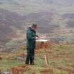
To complement the archaeological work, and to provide a context for the monuments, the Royal Commission, with the financial support of Historic Scotland and Scottish Natural Heritage, has commissioned Dr Richard Tipping to undertake a palaeo-environmental reconstruction of the Rogart basin.
RCAHMS (DES 1995, 115-6)
See also RCAHMS Annual Report 1994-5, 16; 1995-6, 18.
Structures database: DX001425
Linework: TM000355