
Cnoc Dubh


Cairnfield (Prehistoric)
Site Name Cnoc Dubh
Classification Cairnfield (Prehistoric)
Canmore ID 5897
Site Number NC70NW 57
NGR NC 7180 0600
Datum OSGB36 - NGR
Permalink http://canmore.org.uk/site/5897


- Council Highland
- Parish Rogart
- Former Region Highland
- Former District Sutherland
- Former County Sutherland
Field Visit (19 May 1981)
NC70NW 57 717 060.
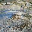
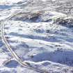
Centred on NC 717 060, along the lower E-facing slopes of Cnoc Dubh, are numerous stony heaps typical of a hut circle-associated field system. There are a number of hut circles known in the neighbourhood.
Visited by OS (J M) 19 May 1981.
Field Visit (18 May 1995)
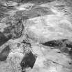
There is a scatter of small cairns on the heather-covered SE flank of Cnoc Dubh. The cairns, which measure up to 4m in diameter and 0.4m in height, are disposed along the crests and sides of two ridges of better drained ground, separated by a boggy gully.
(ROG95 932)
Visited by RCAHMS (DCC) 18 May 1995

