
Stenton, Old Parish Church


Architectural Fragment (14th Century), Burial Ground (Medieval), Church (16th Century), Dovecot (Post Medieval), Font (Medieval)
Site Name Stenton, Old Parish Church
Classification Architectural Fragment (14th Century), Burial Ground (Medieval), Church (16th Century), Dovecot (Post Medieval), Font (Medieval)
Alternative Name(s) Stenton Old Parish Church; Stenton Tower
Canmore ID 57841
Site Number NT67SW 8
NGR NT 62152 74276
Datum OSGB36 - NGR
Permalink http://canmore.org.uk/site/57841


- Council East Lothian
- Parish Stenton (East Lothian)
- Former Region Lothian
- Former District East Lothian
- Former County East Lothian
NT67SW 8 62152 74276
(NT 6215 7427) Church (NR) (Remains of)
OS 6" map (1957)
The remains of the former parish church, presumably that built in 1561 on its transfer from Pitcox (NT67NW 15). The whole structure appears to be 16th c. although the apparently 14th c. finial on the structure covering the Well of the Holy Rood (NT67SW 7) is said to have come from this church.
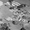
The church has been oblong, with a tower at the west end (in use as a dovecot in 1915), and a small sacristy (used as a burial-place by the Sydserffs of Ruchlaw) projecting from the north wall. The walls, of roughly coursed rubble, stand to a maximum height of 8ft.
RCAHMS 1924; J R Walker 1883
As described above.
Revised at 25".
Visited by OS (RD) 6 April 1966.
EXTERNAL REFERENCE:
Scottish Record Office
Sydserff Aisle in Stenton Church.
Permission granted to John Sydserff of Rouchlaw to build an aisle in the back parts of the Church in order to erect a loft for the accomodation of his family. He undertakes to make good any damage caused by the work.
1772 GD205/Box39/Portfolio 9
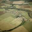
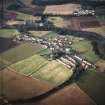
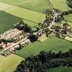
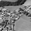
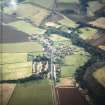
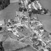
Field Visit (1 September 1915)
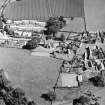
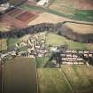
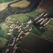
The ruin of the old parish church lies within the churchyard adjoining the modern church in the village of Stenton. It is an oblong structure (fig. 158 [plan]) built of local rubble roughly coursed and measures internally 63 feet along the incomplete east and west walls and 18 feet from north to south; the highest portion of walling standing is the south wall, which in parts is some 8 feet in height. On the north there projects a small sacristy, 12 feet by 18 ¼ feet, now occupied as the burial place of the Sydserffs of Ruchlaw.
At the western end of the church, but not centering with it, there is a tower (fig. 25) of two tiers, square on plan, which is complete, well preserved and is used as a dovecot. It is built of the same rubble as the church but in more regular courses with long and short quoins. The tower appears to be a structure of the16th century, to which period the church also may be assigned. The church is entered from the south by a doorway with a segmental head in two orders each moulded with a quirked edge roll. The jambs are of similar section and have splayed stops and rudimentary capitals following the plan of the mouldings above and below. A window west of the doorway has a splayed and back set margin of later date than the doorway. The tower contains three storeys, all unvaulted, the two lower of which have communicated with the church. It is entered by a doorway in the south wall, which has splayed jambs and lintel; communication between the floors has been by a ladder. The upper portion of the walls is intaken, where a splayed offset course returns horizontally. The upper storey is lit by a round-headed window in each wall with deeply splayed jambs. The gables are crowstepped, and the roof is of wood covered with slates. There was a gallery in the west end entered from a fore-stair.
FONT.There is a circular font at the eastern end of the church, which is now used as a receptacle for plants. The external diameter is 2 feet 7 inches, the total height 2 feet 1 inch, and it has a lip on the exterior rim to receive a leaden lining. It is illustrated and described in Proc. Soc. Ant. Scot. xxi., p. 357.
CROSS SOCKET. Beside the font is a stone, gabletted on each face and mortised on the upper surface to receive a small cross shaft, which is evidently the termination of a pinnacle or the apex of the east gable. It appears to be earlier than any portion of the present church and dates probably from the late 13th or early 14th century.
HISTORICAL NOTE. The parish was of old known as Pitcox or ‘Pitcokis’, and the parish church was at the village of that name a little over a mile to the north-east, where now only the site of the old church is known, Pitcox was a prebend in the collegiate church of Dunbar (1). The parish church was transferred to its present position in 1561 (2).
RCAHMS 1924, visited 1 September 1915.
(1) Act. Parl. Scot. iv., p. 294; (2) Fasti Eccles. Scot. (new edit.), i., p. 420.
Photographic Survey (September 1960 - 1962)
Photographic survey of dovecots in East Lothian by the Scottish National Buildings Record in 1960-1962.
Photographic Survey (December 1961)
Survey of Stenton Old Parish Church, tower and churchyard, East Lothian, by Kitty Cruft at the Scottish National Buildings Record in 1961.
The tower was at this time used as a dovecot.
Project (1996 - 2006)
A project recording graveyard monuments within the parish of Traprain.

