Accessibility

Font Size

100% 150% 200%

Background Colour

Default Contrast
Close Reset

Doon Hill

Settlement (Iron Age)

Site Name Doon Hill

Classification Settlement (Iron Age)

Canmore ID 57648

Site Number NT67NE 45

NGR NT 68607 75355

NGR Description Centre

Datum OSGB36 - NGR

Permalink http://canmore.org.uk/site/57648

Ordnance Survey licence number AC0000807262. All rights reserved.
Canmore Disclaimer. © Bluesky International Limited 2025. Public Sector Viewing Terms

Toggle Aerial | View on large map

Digital Images

Aerial view of Doon Hill, taken from the SSW, centred on a cropmark of a rectilinear enclosure.  A cropmark of a possible palisaded enclosure, situated to the N, is visible in the centre left of the photograph.  A timber hall encloure, also to the N, is visible in the top left-hand corner of the photograph.
Aerial view of Doon Hill, taken from the SSW, centred on a cropmark of a rectilinear enclosure.  A cropmark of a possible palisaded enclosure, situated to the N, is visible in the centre left of the photograph.  A timber hall encloure, also to the N, is visible in the top left-hand corner of the photograph.Oblique aerial view of the cropmarks of the forts on Doon Hill, looking SSE.Aerial view of Doon Hill, taken from the W, centred on a cropmark of a rectilinear enclosure.  A cropmark of a possible palisaded enclosure, situated to the N, is visible in the left-hand corner of the photograph.Oblique aerial view.Oblique aerial view centred on the cropmarks of the rectilinear settlement and other cropmarks with the timber halls and enclosure and the cropmarks of the possible enclosure adjacent, taken from the S.Oblique aerial viewOblique aerial view of the cropmarks of the forts on Doon Hill, looking WSW.Oblique aerial view centred on the cropmarks of the rectilinear settlement and further cropmarks, taken from the SSE.Oblique aerial view centred on the cropmarks of the rectilinear settlement and further cropmarks, taken from the SSE.Oblique aerial view centred on the cropmarks of the rectilinear settlement and other cropmarks with the timber halls and enclosure and the cropmarks of the possible enclosure adjacent, taken from the WSW.Doon Hill, NT67NE 45, Ordnance Survey index card, RectoAerial view of Doon Hill, taken from the NNW, centred on a cropmark of a possible palisaded enclusure.  A cropmark of a rectilinear enclosure, situated to the S, is visible in the top centre of the photograph.  A timber hall encloure, situated to the N, is visible in the bottom left-hand corner of the photograph.Oblique aerial view of Doon Hill centred on the cropmarks of a rectlinear settlement and other cropmarks, taken from the SE.Oblique aerial view of Doon Hill centred on the cropmarks of a rectlinear settlement and other cropmarks, taken from the NW.Doon Hill, NT67NE 45, Ordnance Survey index card, RectoOblique aerial view of the cropmarks of the forts, looking WNW.Oblique aerial view of the cropmarks of the rectilinear settlement enclosure, looking W.Aerial view of Doon Hill, taken from the NW, centred on the cropmark of a rectilinear enclosure.  A cropmark of a possible palisaded enclosure, situated to the N, is visible in the bottom centre of the photograph.Oblique aerial view centred on the cropmarks of the rectilinear settlement and further cropmarks, taken from the NE.Aerial view of Doon Hill, taken from the SSW, centred on a cropmark of a rectilinear enclosure.  A cropmark of a possible palisaded enclosure, situated to the N, is visible in the centre left of the photograph.  A timber hall encloure, also to the N, is visible in the top left-hand corner of the photograph.Aerial view of Doon Hill, taken from the NE, centred on a cropmark of a possible palisaded enclosure.  A cropmark of a rectilinear enclosure, situated to the S, is visible in the centre left of the photograph.  A timber hall encloure, situated to the N, is visible in the bottom centre of the photograph.Oblique aerial view.Oblique aerial view.Aerial view of Doon Hill, taken from the NNW, centred on a cropmark of a possible palisaded enclusure.  A cropmark of a rectilinear enclosure, situated to the S, is visible in the top centre of the photograph.  A timber hall encloure, situated to the N, is visible in the bottom left-hand corner of the photograph.Aerial view of Doon Hill, taken from the NW, centred on a cropmark of a possible palisaded enclosure.  A cropmark of a rectilinear enclosure, situated to the S, is visible in the top centre of the photograph.Aerial view of Doon Hill, taken from the W.  A cropmark of a rectilinear enlcosure is visible in the bottom left hand corner of the photograph.  A cropmark of a possible palisaded enclosure is visible in the bottom centre.  A timber hall enclosure is visible in the centre left of the photograph.Oblique aerial viewAerial view of Doon Hill, taken from the NE, centred on a cropmark of a possible palisaded enclosure.  A cropmark of a rectilinear enclosure, situated to the S, is visible in the centre left of the photograph.  A timber hall encloure, situated to the N, is visible in the bottom centre of the photograph.Oblique aerial view of the cropmarks of the rectilinear settlement enclosure, looking ENE.Oblique aerial view centred on the cropmarks of the rectilinear settlement and further cropmarks, taken from the WNW.Oblique aerial view of Doon Hill centred on the cropmarks of a rectlinear settlement and other cropmarks, taken from the NNW.Oblique aerial view of Doon Hill centred on the cropmarks of a rectlinear settlement and other cropmarks, taken from the SW.Oblique aerial view centred on the cropmarks of the rectilinear settlement and cropmarks with the cropmarks of the possible enclosure adjacent, taken from the SSE.Doon Hill, NT67NE 45, Ordnance Survey index card, page number 1, Recto

Administrative Areas

  • Council East Lothian
  • Parish Dunbar
  • Former Region Lothian
  • Former District East Lothian
  • Former County East Lothian

Archaeology Notes

NT67NE 45 NTt 68610 75359

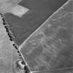
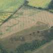
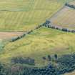
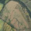
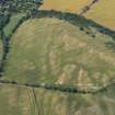
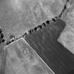
(NT 6860 7535) Air photographs (CPE/Scot/UK257: 3099-3100, flown 1947) reveal the cropmarks of a rectangular enclosure with sharp corners, 300 yds ESE of the fort on Doon Hill (NT67NE 20). The enclosure is bounded by a single ditch and measures 200ft from E to W by 150ft transversely; the entrance, which is over 25ft wide, is situated in the centre of the W side.

RCAHMS Marginal Lands MS 1954

No evidence of any feature can be found on the ground. Inspection of the terrain and of the air photographs suggests that this is a doubtful antiquity.

Visited by OS (EGC) 7 April 1966

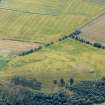
Also visible on CUCAP and RCAHMS air photographs. Listed as an enclosure by both these authorities.

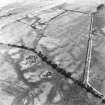
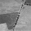
One of the field drains visible on oblique aerial photographs (RCAHMSAP 1995: C46492) and oriented N-S could be a field boundary that is depicted on the 2nd edition of the OS 6-inch map (Haddingtonshire 1894, sheet vii SW).

Information from RCAHMS (OGS) 6 May 2008

Activities

Aerial Photographic Interpretation (5 October 1954)

Enclosure, Doon Hill (Dunbar).

A rectangular enclosure with sharp corners, 300 yds ESE of the fort on Doon Hill. The enclosure is bounded by a single ditch and measures 200 ft from E to W by 150 ft transversely: the entrance, which is over 25 ft wide, is situated in the centre of the W side (1).

(1) CPE Scot UK 257, 3099-3100.

Information from RCAHMS (KAS) 5 October 1954.

Reference (1957)

This site is noted in the ‘List of monuments discovered during the survey of marginal land (1951-5)’ (RCAHMS 1957, xiv-xviii).

Information from RCAHMS (GFG), 24 October 2012.

Aerial Photographic Transcription (18 July 2019)

An interpretative transcription, or mapping, of information on oblique aerial photographs was produced on 18 July 2019.

Note (6 October 2022)

The location, classification and period of this site have been reviewed.

Note (10 June 2023)

The location, classification and period of this site have been reviewed and changed from ENCLOSED SETTLEMENT (IRON AGE), FIELD BOUNDARY(S) (POST MEDIEVAL).

References

MyCanmore Image Contributions


Contribute an Image

MyCanmore Text Contributions