|
Photographs and Off-line Digital Images |
EL 2843 PO |
Cambridge University Collection for Aerial Photography |
Oblique aerial view. |
1983 |
Item Level |
|
|
Photographs and Off-line Digital Images |
EL 3108 |
RCAHMS Aerial Photography |
Oblique aerial view. |
1976 |
Item Level |
|
|
Photographs and Off-line Digital Images |
EL 3109 |
RCAHMS Aerial Photography |
Oblique aerial view. |
1976 |
Item Level |
|
|
Photographs and Off-line Digital Images |
EL 4875 |
John Dewar |
Oblique aerial view. |
1971 |
Item Level |
|
|
Photographs and Off-line Digital Images |
EL 4876 |
John Dewar |
Oblique aerial view. |
1971 |
Item Level |
|
|
Photographs and Off-line Digital Images |
EL 2971 |
RCAHMS Aerial Photography |
Oblique aerial view. |
1976 |
Item Level |
|
|
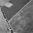
Photographs and Off-line Digital Images |
D 14054 |
RCAHMS Aerial Photography |
Aerial view of Doon Hill, taken from the NW, centred on the cropmark of a rectilinear enclosure. A cropmark of a possible palisaded enclosure, situated to the N, is visible in the bottom centre of the photograph. |
24/6/1997 |
Item Level |
|
|
Photographs and Off-line Digital Images |
D 14055 |
RCAHMS Aerial Photography |
Aerial view of Doon Hill, taken from the W, centred on a cropmark of a rectilinear enclosure. A cropmark of a possible palisaded enclosure, situated to the N, is visible in the left-hand corner of the photograph. |
24/6/1997 |
Item Level |
|
|
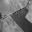
Photographs and Off-line Digital Images |
D 14056 |
RCAHMS Aerial Photography |
Aerial view of Doon Hill, taken from the SSW, centred on a cropmark of a rectilinear enclosure. A cropmark of a possible palisaded enclosure, situated to the N, is visible in the centre left of the photograph. A timber hall encloure, also to the N, is visible in the top left-hand corner of the photograph. |
24/6/1997 |
Item Level |
|
|
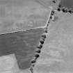
Photographs and Off-line Digital Images |
D 14057 |
RCAHMS Aerial Photography |
Aerial view of Doon Hill, taken from the NE, centred on a cropmark of a possible palisaded enclosure. A cropmark of a rectilinear enclosure, situated to the S, is visible in the centre left of the photograph. A timber hall encloure, situated to the N, is visible in the bottom centre of the photograph. |
24/6/1997 |
Item Level |
|
|
Photographs and Off-line Digital Images |
D 14058 |
RCAHMS Aerial Photography |
Aerial view of Doon Hill, taken from the NNW, centred on a cropmark of a possible palisaded enclusure. A cropmark of a rectilinear enclosure, situated to the S, is visible in the top centre of the photograph. A timber hall encloure, situated to the N, is visible in the bottom left-hand corner of the photograph. |
24/6/1997 |
Item Level |
|
|
Photographs and Off-line Digital Images |
D 14059 |
RCAHMS Aerial Photography |
Aerial view of Doon Hill, taken from the NW, centred on a cropmark of a possible palisaded enclosure. A cropmark of a rectilinear enclosure, situated to the S, is visible in the top centre of the photograph. |
24/6/1997 |
Item Level |
|
|
Photographs and Off-line Digital Images |
D 14060 |
RCAHMS Aerial Photography |
Aerial view of Doon Hill, taken from the W. A cropmark of a rectilinear enlcosure is visible in the bottom left hand corner of the photograph. A cropmark of a possible palisaded enclosure is visible in the bottom centre. A timber hall enclosure is visible in the centre left of the photograph. |
24/6/1997 |
Item Level |
|
 |
On-line Digital Images |
SC 651809 |
RCAHMS Aerial Photography |
Aerial view of Doon Hill, taken from the SSW, centred on a cropmark of a rectilinear enclosure. A cropmark of a possible palisaded enclosure, situated to the N, is visible in the centre left of the photograph. A timber hall encloure, also to the N, is visible in the top left-hand corner of the photograph. |
24/6/1997 |
Item Level |
|
 |
On-line Digital Images |
SC 651813 |
RCAHMS Aerial Photography |
Aerial view of Doon Hill, taken from the NE, centred on a cropmark of a possible palisaded enclosure. A cropmark of a rectilinear enclosure, situated to the S, is visible in the centre left of the photograph. A timber hall encloure, situated to the N, is visible in the bottom centre of the photograph. |
24/6/1997 |
Item Level |
|
|
Photographs and Off-line Digital Images |
D 14500 |
RCAHMS Aerial Photography |
Oblique aerial view of Doon Hill centred on the cropmarks of a rectlinear settlement and other cropmarks, taken from the NNW. |
25/7/1997 |
Item Level |
|
|
Photographs and Off-line Digital Images |
D 14501 |
RCAHMS Aerial Photography |
Oblique aerial view of Doon Hill centred on the cropmarks of a rectlinear settlement and other cropmarks, taken from the NW. |
25/7/1997 |
Item Level |
|
|
Photographs and Off-line Digital Images |
D 14502 |
RCAHMS Aerial Photography |
Oblique aerial view of Doon Hill centred on the cropmarks of a rectlinear settlement and other cropmarks, taken from the SW. |
25/7/1997 |
Item Level |
|
|
Photographs and Off-line Digital Images |
D 14503 |
RCAHMS Aerial Photography |
Oblique aerial view of Doon Hill centred on the cropmarks of a rectlinear settlement and other cropmarks, taken from the SE. |
25/7/1997 |
Item Level |
|
 |
On-line Digital Images |
SC 761544 |
RCAHMS Aerial Photography |
Aerial view of Doon Hill, taken from the NNW, centred on a cropmark of a possible palisaded enclusure. A cropmark of a rectilinear enclosure, situated to the S, is visible in the top centre of the photograph. A timber hall encloure, situated to the N, is visible in the bottom left-hand corner of the photograph. |
24/6/1997 |
Item Level |
|
|
Photographs and Off-line Digital Images |
C 46491 |
RCAHMS Aerial Photography |
Oblique aerial view centred on the cropmarks of the rectilinear settlement and further cropmarks, taken from the SSE. |
28/6/1995 |
Item Level |
|
|
Photographs and Off-line Digital Images |
C 46492 |
RCAHMS Aerial Photography |
Oblique aerial view centred on the cropmarks of the rectilinear settlement and further cropmarks, taken from the NE. |
28/6/1995 |
Item Level |
|
|
Photographs and Off-line Digital Images |
C 46493 |
RCAHMS Aerial Photography |
Oblique aerial view centred on the cropmarks of the rectilinear settlement and further cropmarks, taken from the WNW. |
28/6/1995 |
Item Level |
|
|
Photographs and Off-line Digital Images |
C 46494 |
RCAHMS Aerial Photography |
Oblique aerial view centred on the cropmarks of the rectilinear settlement and further cropmarks, taken from the SSE. |
28/6/1995 |
Item Level |
|


