
Pricing Change
New pricing for orders of material from this site will come into place shortly. Charges for supply of digital images, digitisation on demand, prints and licensing will be altered.
Jedburgh, Abbey Place, Newgate


Gatehouse (18th Century)
Site Name Jedburgh, Abbey Place, Newgate
Classification Gatehouse (18th Century)
Alternative Name(s) Steeple; Tower; Tolbooth; Entrance To Bridewell Jail; Prison; Old County Buildings; Sheriff Court
Canmore ID 57128
Site Number NT62SW 48
NGR NT 64994 20531
Datum OSGB36 - NGR
Permalink http://canmore.org.uk/site/57128


- Council Scottish Borders, The
- Parish Jedburgh
- Former Region Borders
- Former District Roxburgh
- Former County Roxburghshire
NT62SW 48 64994 20531.
(NT 6499 2053) Newgate (NAT)
OS 25" map, (1972).
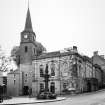
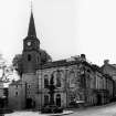
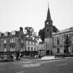
New Gate, Jedburgh: Near the SE corner of the Market Place there is a gatehouse, surmounted by a steeple, which today leads to the churchyard of the Abbey on the S and to the undercroft of the county buildings on its W side. In all probability it occupies the site of the principal entrance to the Abbey precinct, but as it stands it is not earlier than the 18th century. In its present form it comprises an oblong harled structure pierced by a central pend, above which there is a tower, ashlar-built where it rises above the slate roofs of the side buildings, and surmounted by a broach spire with a weather-vane. The tower contains a bell-chamber and there is a clock-chamber above that. The pend, arched at either end, is joisted and not vaulted.
On the N side of the gatehouse there is a panel inscribed 'NEW GATE 1755'; higher up is an armorial shield, dated 1720, inserted within the margin of a built-up window. Below the belfry window on the S side there is a panel with an inscription illegible but for the date 1761, the date of the tower and steeple.
RCAHMS 1956, visited 1946.
Publication Account (1996)
This comprises an oblong structure, 14.9m from E to W by 6.2m and pierced by a central pend above which there rises a tower surmounted by a spire 36m high. The main block and the lower stages of the tower are of harled rubble, but the upper part of the tower and the spire have been rendered and lined to imitate ashlar, over decayed ashlar which was exposed until the 1960s. The pend, which is entered by recessed segmental arches and has ajoisted cei ling, was originally closed at each end by folding gates. In its side-walls there are doorways giving access to vaulted cells in the flanking blocks, which were originally three-storeyed. The E block retains its hipped roof, but the Wend was heightened, probably when it was annexed to the County Buildings in the early 19th century. The fenestration is irregular, but some small original openings are preserved in the N front.
The lower stages of the tower are slightly recessed between the flanking blocks, like the pend-arches below. Its E angles have stepped quoins in the stage that rises above the slated roof of the E block, but the W elevation is concealed by the heightened adjacent block. Above a plain band, which probably marks the limit of the work completed in 1755-6, there is a tall plain stage with round-headed belfry-openings and a moulded cornice. The clock-stage has a simple pedimented projection on each face, and a similar cornice. The broached base and the octagonal spire are ashlar-built.
The N arch of the pend bears the painted inscription, 'Entrance to Bridewell Jail', and above it there is a simple date-stone inscribed 'Newgate 1755'. Set in the blocked first floor window above this there is a panel which was formerly incorporated in a public well in the market-place. It bears a shield with the burgh arms, a mounted warrior armed with a spear, with the motto 'Strenue et Prospere' ('With vigour and success') and the painted date '1720'. A stone inscribed '1761', marking the completion of the tower and spire, is built into the lower part of the S face of the belfry-stage.
A forestair against the E wall gives access, through a door with a simple architrave, to the rooms in the E block and thence to the tower. The first-floor room was in use as a museum in 1859, but it was subsequently fitted up as a kitchen with a large range. It opens into the lowest level of the tower, from which a series of metal stairs and platforms gives access to the upper stages, and also to the much-altered second-floor room. There was also access at both levels from the tower to the W wing, but the original openings have been blocked and the rooms there, which have been altered, are now entered from the County Buildings.
The lowest level of the belfry contains three early bells. The oldest, which is of pre-Reformation date and probably belonged to the abbey, measures 0.37m in height by 0.43m in diameter and bears a black-letter inscription: CAMPANA BEATE MARGARETE VIRGlNIS ('the bell of the blessed virgin Margaret'). The second bell, which came from the old parish church in the nave of the abbey, is 0.58m in height and 0.76m in diameter. It is inscribed: ROBERT LORD IEDBURG HIS GIFT TO THE KIRK OF IEDBWRG 1692 /JOHN MEIKLL ME FECIT EDINBURGI, and bears two medallions with the donor's arms. The third bell is un inscribed, but it is probably the one supplied by the Mines Royal Company of London in 1780, after a bell made by them in the previous year 'had entirely lost its sound'. The upper levels of the belfry contain four quarter-bells, cast by J Warner, London, in 1880 to serve the clock of 1881 on the level above.
Information from ‘Tolbooths and Town-Houses: Civic Architecture in Scotland to 1833’ (1996).
Sbc Note (15 April 2016)
Visibility: Standing structure or monument.
Information from Scottish Borders Council

