
Following the launch of trove.scot in February 2025 we are now planning the retiral of some of our webservices. Canmore will be switched off on 24th June 2025. Information about the closure can be found on the HES website: Retiral of HES web services | Historic Environment Scotland
Skid Hill


Fort (Prehistoric), Whinstone Quarry (Modern)
Site Name Skid Hill
Classification Fort (Prehistoric), Whinstone Quarry (Modern)
Canmore ID 56371
Site Number NT57NW 9
NGR NT 5068 7643
Datum OSGB36 - NGR
Permalink http://canmore.org.uk/site/56371


- Council East Lothian
- Parish Athelstaneford
- Former Region Lothian
- Former District East Lothian
- Former County East Lothian
NT57NW 9 5070 7641.
(NT 5070 7641) Fort (NR)
OS 6" map (1968)
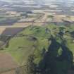
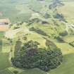
The remains of a fort occupy the summit of Skid Hill. They consist of a terrace 30' wide around the W curve of the hill on the edge of which in the SW is the remains of a wall 10' wide and 1' high. About 22' higher up the steep slope there are traces of an inner rampart. A gap 20' wide near the S end of the outer defence seems to be an entrance. A large quarry encroaches on the S side of the fort (RCAHMS 1924, visited 1913). The surviving portion of the interior is featureless.
RCAHMS MSS 1956
All that can be seen at this site are the terrace which is marked by a scarp 1.7m high and the slight traces of the inner rampart on the N.
Visited by OS (BS) 16 July 1975
Field Visit (31 May 1913)
About 1 ¼ miles south of the town of Haddington lies the short range of the Garleton Hills, rising about 600 feet above sea-level and overlooking the whole of the central and northern portions of the county. On Skid Hill, the highest point in the range, some 600 yards east of the Hopetoun Monument and ¾ mile west of the fort at Kae Heughs (No. 74), slight traces of fortification are to be detected towards the eastern end of the summit. The hill is strongly defended by nature on three sides; steep slopes and rocky cliffs rise about 200 feet on the northern side and about 100 feet on the east and south, while to the west, from which direction it is easiest of access, there is a sharp fall of some 70 feet from the summit to the hollow between it and a lower hill farther west. Round the western curve of the hill, some 16 feet above the bottom of the hollow, there is a terrace 30 feet wide in places, on the edge of which there seems to have been a wall now difficult to trace except at the south-west, where the mound is 10 feet in breadth at the base and rises I foot above the inner level. About 22 feet higher up the steep slope there are traces of an inner rampart. A gap 20 feet wide near the southern extremity of the outer defence seems to betoken the position of an entrance, and the shoulder of the hill appears to have been scarped to the eastern side of the roadway leading to the entrance. A large quarry, the Skid Hill Quarry, encroaches on the southern side of the fort.
RCAHMS 1924, visited 31 May 1913
Field Visit (30 October 1956)
Fort, Skid Hill (Inv. No. 14).
Virtually the whole of the interior of this fort has now been quarried away but the two ramparts recorded in the Inventory on the west side are still visible as shown in the sketch. The ramparts were probably composed of rock rubble, faced or kerbed with drystone-walling. No huts can be seen in the surviving portion of the interior. The work is undoubtedly an Early Iron Age Fort.
Visited by RCAHMS (KAS) 30 October 1956.
(Sketch in Typescript).
Note (15 December 2015 - 31 August 2016)
This fort occupied the summit of Skid Hill, but the greater part of its interior has been destroyed by a now disused quarry and fragments of two ramparts survive only on the N and NW. The sides of the hill are steep, dropping away in craggy outcrops around the N side, the inner rampart following the margins of the summit, and the outer the lip of a lower terrace. Where best preserved on the NW the inner forms a stony bank 0.3m high internally and 1.5m externally, while the outer is spread about 3m in thickness and is 0.5m in external height. While probably roughly oval, the original size of the interior is difficult to estimate, but it must have been in the order of 100m across (0.7ha), and there was probably an entrance approached by a track on the W.
Information from An Atlas of Hillforts of Great Britain and Ireland – 31 August 2016. Atlas of Hillforts SC3873

