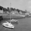
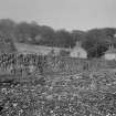
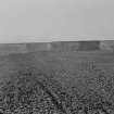
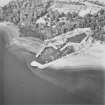
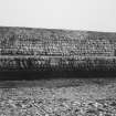
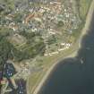
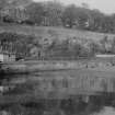
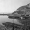
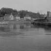
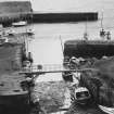
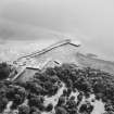
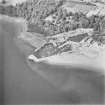
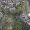
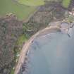
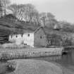
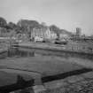
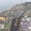
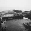
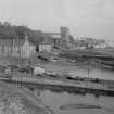
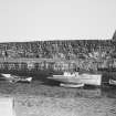
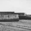
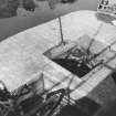
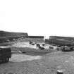
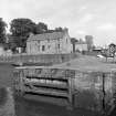
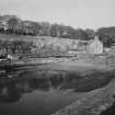
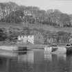
Accessibility

Font Size

100% 150% 200%

Background Colour

Default Contrast
Close Reset

Dysart Harbour

Harbour (19th Century)

Site Name Dysart Harbour

Classification Harbour (19th Century)

Alternative Name(s) New Harbour

Canmore ID 53993

Site Number NT39SW 21

NGR NT 30200 92800

NGR Description Centred NT 30200 92800

Datum OSGB36 - NGR

Permalink http://canmore.org.uk/site/53993

Ordnance Survey licence number AC0000807262. All rights reserved.
Canmore Disclaimer. © Bluesky International Limited 2025. Public Sector Viewing Terms

Toggle Aerial | View on large map

Digital Images

Dysart Harbour.
Aerial view from West.
Dysart Harbour.
Aerial view from West.Dysart Harbour
View of outer basin, from SDysart Harbour
View of building on central pier, from WView from SW showing harbour footbridge with Harbourmaster's House in the background.View of Dysart harbour from SSE.Oblique aerial view.Oblique aerial view centred on the harbour with the monastery, garden, church, churchyard and burial ground adjacent, taken from the W.Oblique aerial view centred on the house, monastery and gardens with the church, burial ground and harbour adjacent, taken from the WSW.View of Dysart harbour from S including detail of harbour wall.View of Dysart harbour showing harbour wall NE.Aerial view from South East.Interior of breakwater, showing rusticated masonry.Dysart, Harbour
View of Inner Basin, looking S to Outer BasinDysart Harbour
View of ruined storehouse on W quay, from SOblique aerial view centred on the house, monastery and gardens with the church, burial ground and harbour adjacent, taken from the SSW.View from South of harbour, St Serf's kirk and The Shore. Includes a top-sail schooner, called the 'Regina Brake'.View of Dysart harbour from S.View of Dysart harbour from NE across outer basin, including slipway in foreground.View of Dysart harbour from S showing St Serf's Kirk and The Shore.Dysart Harbour.
Outer basin and gated channel to inner basin.Dysart Harbour
View down slipway from carpark, from NGeneral oblique aerial view centred on the harbour with the monastery, garden, church, churchyard and burial ground adjacent, taken from the W.View from South of harbour, St Serf's kirk and The Shore. Includes a top-sail schooner, called the 'Regina Brake'.View of Dysart harbour from SW showing St Serf's Kirk and The Shore.Aerial view from West.Aerial view from East South East.Oblique aerial view.Oblique aerial view.Dysart Harbour.
Dock gate with hinge.Dysart Harbour.
Detail of East gate.Dysart Harbour
View of building on tip of central pier, fom WOblique aerial view centred on the harbour with the monastery, garden, church, churchyard and burial ground adjacent, taken from the SSE.View of derelict building in Dysart harbour from SE.View of Dysart harbour from S showing St Serf's Kirk and The Shore.Oblique aerial view.General view from North North West.Dysart Harbour.
Slipway (left) and gated channel to inner basin.Dysart Harbour
View of inner basin and harbour buildings, from SOblique aerial view centred on the harbour with the monastery, garden, church, churchyard and burial ground adjacent, taken from the SW.View of Dysart harbour from SSE.View of Dysart harbour showing detail of entrance to gated channel, from SE.View of Dysart harbour from SW showing St Serf's Kirk and The Shore.Aerial view from South East.Oblique aerial view.Interior of breakwater near landward end, showing variations in masonry.Entrance at low water, from West.Dysart Harbour.
Mechanism of dock gates.Dysart, Harbou
View of Outer Basin from Ashlar Head, looking SEDysart Harbour
View of inner basin and harbour buildings, from WView of Dysart harbour from S.View of Dysart harbour from outer basin, looking NW, including derelict harbour building and entrance to gated channel.View of Dysart harbour showing harbour wall.View of gated channel in Dysart harbour from WNW.Dysart Harbour, NT39SW 21, Ordnance Survey index card, RectoView of outer and inner basins from North.Dysart Harbour.
Recess for dock gates.General view from NNWView of harbour wall in Dysart harbour.Detail of harbour wall in Dysart harbour.View of Dysart harbour from S showing St Serf's Kirk and The Shore.View of Dysart harbour from SW showing St Serf's Kirk and The Shore.Dysart Harbour.
Aerial view from West.Aerial view from West South West.Dysart Harbour, NT39SW 21, Ordnance Survey index card, RectoView of outer and inner basins from North.

Administrative Areas

  • Council Fife
  • Parish Kirkcaldy And Dysart
  • Former Region Fife
  • Former District Kirkcaldy
  • Former County Fife

Archaeology Notes

NT39SW 21 centred 30200 92800

Location formerly cited as NT 302 928.

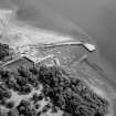
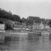
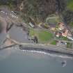
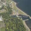
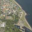
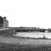
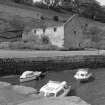
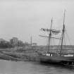
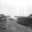
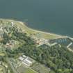
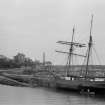
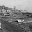
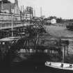
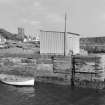
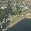
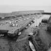
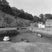
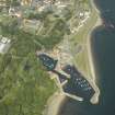
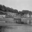
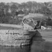
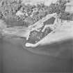
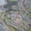
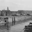
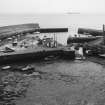
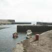
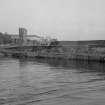
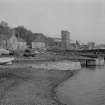
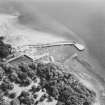
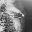
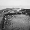
(Location cited as NT 302 928). Harbour, 17th Century and later. Harbour built for coal shipment, with 2 rubble piers forming an outer basin, and an inner, gated basin formed in 1831.

J R Hume 1976.

Site recorded by Maritime Fife during the Coastal Assessment Survey for Historic Scotland, Kincardine to Fife Ness 1996

Architecture Notes

See also NT39SW 70 Dysart, The Shore

Information from Architecture Catalogue Slip:

PLANS:

Kirkcaldy Museum and Library. Harbour improvements:-

1829 - plan of harbour

1829 - plan of sluices

1830 - plans of drawbridge

Undated plans - dock gates and Harbour

Dysart Harbour

Repairs and addition to East Head

Advertisement for tenders, 1803

(Edinburgh Evening Courant, March 26, 1803)

William Sibbald

Site Management (7 December 2009)

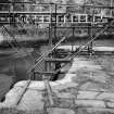
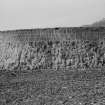
Roughly U-plan tidal basin with harbour mouth to S (at rounded end) and slipway to N; W arm with jetties projecting at W and NW forming mouth to almost rhomboidal-plan wet dock at NW. E pier with high ashlar sea wall to SE. Harbour walls largely ashlar, parts in vertical courses; stone sets to slipways. (ref: Historic Scotland)

Activities

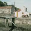
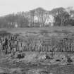
Photographic Survey (October 1964 - November 1964)

Photographic survey of buildings in Dysart by the Scottish National Buildings Record/Ministry of Work in October and November 1964.

Conservation (June 2007 - July 2007)

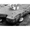
A conservation management plan was conducted on behalf of Fife council to address key remedial issues associated with the erosion of the East Pier at Dysart Harbour.

References

MyCanmore Image Contributions


Contribute an Image

MyCanmore Text Contributions