
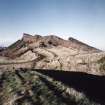
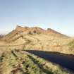
Edinburgh, Holyrood Park, Echoing Rock


Cultivation Terrace(S) (Period Unassigned), Enclosure (Period Unassigned), Field Boundary(S) (Period Unassigned), Rig And Furrow (Medieval) - (Post Medieval)
Site Name Edinburgh, Holyrood Park, Echoing Rock
Classification Cultivation Terrace(S) (Period Unassigned), Enclosure (Period Unassigned), Field Boundary(S) (Period Unassigned), Rig And Furrow (Medieval) - (Post Medieval)
Alternative Name(s) Queen's Park; Samson's Ribs; Holyrood Park Road; Queen's Drive; Powderhouse Corner
Canmore ID 52565
Site Number NT27SE 97
NGR NT 27201 72697
Datum OSGB36 - NGR
Permalink http://canmore.org.uk/site/52565


- Council Edinburgh, City Of
- Parish Edinburgh (Edinburgh, City Of)
- Former Region Lothian
- Former District City Of Edinburgh
- Former County Midlothian
NT27SE 97 2720 7269
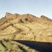
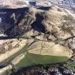
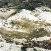
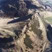
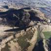
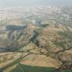
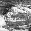
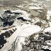
There are cultivation terraces immediately below the southernmost outcrop of the Echoing Rock (NT 272 726). Only the ends of two narrow terraces appear here, but it is possible that the broad rigs that cover the lower parts of this slope may have obliterated a group perhaps once comparable with those at Dunsapie (NT27SE 102).
(OS 6"map, 1966 depicts a bank running from NT 2708 7263 to NT 2714 7274.)
RCAHMS 1951.
These are the indistinct remains of cultivation terraces. Not a good example.
Visited by OS (S F S) 5 December 1975.
Publication Account (1951)
211. Cultivation Terraces, King's Park.
Cultivation terraces are to be seen at the following places in the King's Park:
(i) [NT27SE 76, NT27SE 77 and NT27SE 135] On the E. slopes of Arthur's Seat, both above and below the Queen’s Drive. An account of these very striking group has already been published in the Inventory of Midlothian (1).
(ii) [NT27SE 102] To S. and E. of Dunsapie Fort (2) and extending E. of the fort outside the boundary wall of the Park [NT27SE 102]. (iii) [NT27SE 97] Immediately below the southernmost outcrop of the Echoing Rock; only the ends of two narrow terraces appear here, but it is possible that the broad rigs that cover the lower parts of this slope may have obliterated a group perhaps once comparable with those at Dunsapie.
(iv) [NT27SE 27] On the N.E. face of Haggis Knowe. At the bottom of the slope there are three long terraces, and above them some shorter and less well marked terraces and shelves.
RCAHMS 1951, visited c.1941
(1) No. 11. Cf. also P.S.A.S., lxxiii (1938-9), pp.289 ff., and lxxxi (1946-7), pp. 159 ff.
(2) Inventory of Midlothian and West Lothian, No. 10.
OS Map: Midlothian iii N.E. and S.E
Field Visit (15 December 1998)
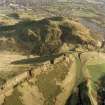
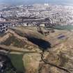
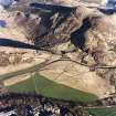
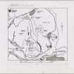
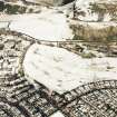
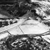
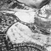
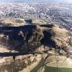
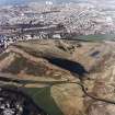
Between Samson's Ribs and the two roundabouts that connect Holyrood Park Road with the Queen's Drive, there are four plots of rig-and-furrow cultivation, a group of cultivation terraces, stretches of two field-banks, an enclosure, and a track. These features are all plotted at 1:5,550 on an archaeological map of Holyrood Park (RCAHMS 1999).
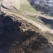
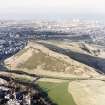
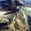
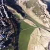
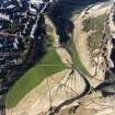
The westernmost plot of rig-and-furrow stands out particularly well under low sunlight, and is separated from the adjacent plot to the E by a well-formed lynchet 1.5m high. The rigs of both plots curve at their N ends, and range in alignment from N and S to NNE and SSW. The rigs are of similar dimensions and measure from 9m to 11m in breadth and 0.2m in height. A field-bank at the SE end of the E plot zig-zags upslope around the base of rock outcrops; this bank is annotated as an 'old fence' on the OS 1:1056 map in 1854 (Edinburgh and its environs 1854, sheet 41).
The remaining two plots of rig-and-furrow cultivation lie to the N on the ground above the outcrops of the Echoing Rock: that to the W has been significantly reduced by the construction of the Queen's Drive, but the four rigs that remain are aligned from E to W and are up to 6m broad; that to the E lies in the angle at Powderhouse Corner, its rigs aligned from ESE to WNW and measuring between 7.5m and 9m in breadth. The group of cultivation terraces lies immediately below the SE end of this plot, and, although they may simply be the result of ploughing along the slope, they appear to be earlier in date and do not share the same alignment. The N end of the second field-bank overlies the two terraces lowest down the slope, and continues down immediately E of the first field-bank as far as the poorly preserved remains of the enclosure. The latter measures 12.5m from ESE to WNW by 11m transversely within a low bank spread 2.5m in thickness; it coincides with a break in the field-bank, suggesting that the bank was robbed to provide material for the enclosure walls. The bank resumes its course to the S, but is again broken by an old track that is shown on the OS maps dating from the mid-19th century. The track appears to cut through some of the rigs, although the furrows of others are dislocated to either side. The track peters out to the WNW in an area shown as allotments on vertical aerial photographs in the late 1940's (CPE/Scot/UK299 5065, flown 21 September 1947).
Visited by RCAHMS (ARG), 15 December 1998.
NMRS, MS/726/96 (59-60, no. 48 and 78, no. 91); RCAHMS 1999.
Condition Survey (February 2016)
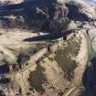
Survey recorded a single terrace or lynchet 1.8 - 2.0m high running south- west to north-east across the open ground to the north-west of Samson’s Ribs. There are traces of rig-and-furrow with a wavelength of 9m on either side of this lynchet. There are 10 rigs to the north- west of the lynchet and 21 to the south-east. At the south-east end of these rigs, below the fort on Samson’s Ribs, there is a curvilinear field bank, 2- 4m wide and 1.5 - 2.0m high. The fieldbank has a very noticeable change in direction. To the south- west, parallel to the low road, there are traces of a terraced trackway 3.5m wide running downslope which appears to have been destroyed by the construction of Duddingston Road. These remains do not appear to be under any direct threat.
Information from Derek Alexander (Centre for Field Archaeology, University of Edinburgh) February 1997, no.48
Alexander 1997
Condition Survey (12 March 2018 - 15 April 2018)
The 2018 CFA Archaeology Ltd condition survey found the site as previously described by Alexander (1997). There is however extensive pathway damage and areas of mole hills.
Information from Graeme Carruthers (CFA Archaeology Ltd) July 2018. OASIS ID: cfaarcha1-317194, no.48
Alexander 1997

