
Edinburgh, Cramond Road South, Lauriston Castle


Country House (19th Century), Tower House (16th Century)
Site Name Edinburgh, Cramond Road South, Lauriston Castle
Classification Country House (19th Century), Tower House (16th Century)
Canmore ID 52030
Site Number NT27NW 1
NGR NT 20294 76097
Datum OSGB36 - NGR
Permalink http://canmore.org.uk/site/52030


- Council Edinburgh, City Of
- Parish Edinburgh (Edinburgh, City Of)
- Former Region Lothian
- Former District City Of Edinburgh
- Former County Midlothian
NT27NW 1.00 20294 76097
NT27NW 1.01 203 761 well
NT27NW 1.02 20291 76070 Sundial
(NT 2030 7609) Lauriston Castle (NR)
OS 6" map, (1966)
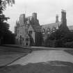
The mansion of Lauriston Castle is a large, mainly modern structure which has grown round the late 16th century tower which forms the SW angle. This tower, which is oblong, 40' x 24', has a central projecting tower on the N, containing a stair. It is now the property of Edinburgh Town Council, and open to the public as a period museum.
D MacGibbon and T Ross 1887-92; RCAHMS 1929, visited 1920; N Tranter 1962-70.
No change to previous information.
Visited by OS (B S) 26 November 1975.
NT 203 759 Four transects were made across the parkland of Lauriston Castle at right-angles to Cramond Road South in order to attempt to establish whether any trace of a road could be found along the projected line of the N section of Cramond Road South. Transects 1 and 2 were respectively 121m and 75m N from the Lodge gateway, and Transects 3 and 4 were 28m and 63m S. In all except Transect 4 high-resistance areas were found along the projected line, and in Transect 2 a section derived from a linear array measurement showed a plausible cross-section. Other high-resistance areas suggested dumping and levelling of the parkland and the lack of any similar high resistance in Transect 4 suggests robbing out.
Sponsors: Edinburgh Archaeological Field Society, University of Edinburgh - Dept of Geology and Geophysics.
H M D Jones 2000
NT 2030 7585 Within the grounds of Lauriston Castle and a little to the N of the gatehouse, ground clearance for the creation of a picnic area revealed an irregular line of stone. Upon cleaning, pottery including late and post-medieval material was found, though the stone line was found to be an outcrop of bedrock.
Sponsors: City of Edinburgh Council Archaeology Service, Edinburgh Archaeological Field Society.
V E Dean 2001
NT 203 759 A fifth transect was made on the S edge of the Lauriston Castle grounds to complete the study previously reported (DES 2000, 35). The area surveyed extended 14m into the park from the S wall and was 22m long across the projected line of Cramond Road South. No high-resistance readings were logged that could indicate crossing the line of a road. The southern area of the parkland was added late to the estate and was for many years under cultivation; robbing out is possible. A full report covering all transects is in preparation.
Sponsors: Historic Scotland, Edinburgh Archaeological Field Society, City of Edinburgh Council Archaeology Service.
H M D Jones 2001
NT 2015 7608 The site for the new Japanese Garden at Lauriston Castle lies immediately to the W of the 16th-century tower house, within the designed gardens surrounding the house. Due to its close proximity to the tower house and the possibility that it may overly the route of the Roman road leading from the nearby fort at Cramond, an archaeological evaluation was undertaken.
Eleven trenches were machine-excavated, sampling c 10% of the area. These were targeted based upon the results of the earlier geophysical survey, which suggested the location of several large areas of demolition material, a possible circular ditched enclosure or garden features, and shallow paths or walls and drains relating to the post-medieval use of the site as a garden.
The results of the evaluation demonstrated that the possible ditched enclosure was natural in origin, representing a change in the underlying natural clays. Only two significant archaeological features were discovered: a small late/post-medieval pit and the foundations of a clay-bonded late medieval wall. The wall probably represents the western boundary wall for the estate surrounding the original 16th-century tower house.
Sponsor: City of Edinburgh Council.
J A Lawson 2001
A geophysical survey was carried out on ground next to the Lauriston Castle estate by Edinburgh Archaeological Field Society. The land, known as Farl O' Cakes Field, was subject to a geophysical survey. Often considered to be the site of a Roman burial ground, a number of anomalies were found but could not be clearly identified.
H M D Jones, 2006
NT27NW 1.00 20294 76097
See Architecture Catalogue, as drawings still to be entered into database.
ARCHITECT: William Burn, 1827 - alterations and additions
W. H. Playfair, 1845 - gabled porches
OWNER: Edinburgh Corporation
NMRS REFERENCE:
Printroom:
W Schomberg Scott Photograph Collection Acc.no. 1997/39
View looking up to turrets
Inglis Photograph Collection Acc.no.1994/90
Exterior: entrance front, oblique view of entrance front, 2 prints (different formats).
Interior: drawing room, 2 prints. dining room, 2 identical prints and 1 with different table cover (see: C 12772).
REFERENCE:
NATIONAL LIBRARY OF SCOTLAND
MS 9704 Letters from W H Playfair re building and gardens and progress of do 1844 etc.
Nattees Drawings, Vol. IV, nos 40 - 42 - 3 drawings
D3/E (P)
NMRS Miscellaneous
Sir Walter Scott's Journal, December 3rd 1827
"Went with Tom Allen to see his building at Lauriston where he has displayed good taste - supporting instead of tearing down and destroying the old chateau which once belonged to the famous Mississippi Law. The additions are in very good taste, and will make a comfortable house. Mr Burn, architect, would feign have had the old house pulled down, which I wonder at in him, though it would have had the practice of most of his brethren."
Field Visit (3 December 1920)
Lauriston Castle.
About half a mile to the north of Barntongate (Davidson's Mains) Station the mansion of Lauriston Castle (Fig.46) rises within its parks and looks northward across the firth to Fife. It is a large and mainly modern structure which has grown round the late 16th-century tower forming the south-west angle of the present mansion. This tower is a structure of three storeys and an attic, and is oblong on plan, measuring 40 by 24 feet. It has on the north a central projecting tower, which is circled at base where it houses a turnpike, and rectangular above, where it contains bed-chambers. The turnpike ascends only to the second floor; the chambers above it were reached by a small turret-stair corbelled out in the north-west re-entrant angle. Larger turrets, within which are chambers, are corbelled out at the southern angles above first floor level and rise to the wall-head; the sill of the upper turret-window looking west projects as a shelf for a lantern. The masonry is of rubble. The entrance and the dormers have moulded architraves; the jambs and lintels of other windows were originally chamfered or rounded. A moulded eaves-course returns at the wall-head and beneath the dormer sills; the gables are crow-stepped. The roofs, which are of timber slated, appear to have been renewed, but the stone ridging is original. The south-eastern dormer retains its original triangular pediment, which is inscribed D.E.M. for Dame Elizabeth Mowbray, daughter of Sir Robert Mowbray of Barnbougle, second wife of Sir Archibald Napier of Merchiston (1). The pediment of the neighbouring dormer is modern; the original pediment bore (2) S. A. N. for Sir Archibald Napier, who probably built the tower. These pediments had fretted margins, which bore scrolls resting on rosettes and terminating in fleurs-de-lys finials, flanking the apex finial, which was wrought as a thistle. The north-west dormer bears in the tympanum a shield parted per pale and charged with, dexter, an oak tree eradicated fessways betwixt three pheons, for Dalgleish, and sinister, erminois, on a chief three mullets, for Douglas of Pumpherston (3). The only defensive features in the building are the filled-in gun-loops facing north and east at basement level and the two tiers of quatrefoiled loops in the southern turrets.
The entrance to the tower does not appear to be in situ, for it is in the south wall, and has subsequently been contracted to form a window; above it is a panel inscribed : R.D. /ASTRA NEC VITÆ MODERATORES NEC/BONORVM MEORVM CAUSAS AGNO/SCO HÆC QUÆ POSSIDEO DEI/BENIGNITATI ACCEPTA FERO EJVS/FIDEI TUTANDA VOLUNTATI DISPONEN/DA COMMITTO AB EO GRATIAM OMNIBVS/PRO IPSO UTENDI EXPETO ET EXPECTO/ROBERT DALG(I.) ISH. IEAN DOUGLASS(3)/ANAGRAMME/GODS GREAT AND HE IS ALL OUR BLIS: ‘I do not acknowledge the stars as either the rulers of life or the causes of my good fortune. The things which I possess I ascribe to the goodness of God. I commit their protection to His faith, their disposal to His will. From Him I hope and pray for grace to use them all for Him’.
A second stone panel has been inserted west of the last; it bears a horoscope and is inscribed: S(IR) ALEX(ANDE)R NA/PEIR (4) SONE TO/S(IR) AR(CHIBALD) OF MER/(C)H(IE)STO(V)NE/(HI)S (CELE)STI/(AL) THEM (i.e. THEME).
The basement contains two parallel and intercommunicating cellars ceiled with semicircular barrel-vaults. The lowest flight of the turnpike was closed, but has recently been opened. A mural stair, opening above in the mural chamber now used as a strong room, and below in the western cellar, which became an entrance hall, evidently dates with the southern entrance. Latterly a new stair has been formed at the north-east angle, which has an inward projection on both the basement and Hall floors.
The first floor was occupied solely by the Hall, but this has been modernised; the strong room window has an iron grille that is apparently original. A small mural chamber is secreted above the strong room. It is reached from a tiny stair, only 1 foot 7 inches wide, that opens off the west ingo of the west window in the Hall and is concealed by the window shutter. The chamber, which has a small window, is 4 feet 11 inches wide, 9 feet 4 inches long, and 6 feet 4 inches in height. A bulkhead is formed in the floor to give headroom below. The ceiling is flagged. A squint is provided to overlook the Hall.
On each of the upper floors are two bedrooms in the main block, on which the little turret chambers open. These rooms, like the Hall, have been modernised. The tower is structurally in good preservation; within it and the additions is a fine collection of old furniture.
MISCELLANEOUS. The following articles were brought from the house of Cartsburn, Greenock, by Mr. T. M. Crawfurd when he bought the present property in 1871, and his house at Cartsburn was demolished (5):
(1) A "lectern" sundial (Fig. 56), of which the upper portion, inscribed 1684, alone is original. It contains 26 dials, and stands on the lawn south of the Tower.
(2) A pediment from a dormer window inscribed with the initials of Thomas Crawfurd and his wife, Jean Semple. Crawfurd built the house of Cartsburn in 1672, and died 1695. This stone is now placed over the mineral well.
(3) In the same position as (2) is another pediment bearing the date 1672.
(4) A panel on the outside wall of the library, on which the Crawfurd arms are blazoned in colour, with the motto, Quod Tibi Hoc Alteri,and the date 1673.
(5) A number of balusters utilised in outside construction which are of about the date 1672.
The house with its contents and grounds is now vested in the Corporation of Edinburgh as trustees for the nation.
RCAHMS 1929, visited 3 December 1920.
(1) The marriage was in 1570 or 1571. Lauriston Castle, by John A. Fairley, p. 25; (2) Ibid.,p. 28; (3) Robert Dalgleish of Lauriston (cj. p . xli) married Jean, daughter of Joseph Douglas of Pumpherston. Ibid., p. 50; (4) Sir Alexander Napier became a Lord Ordinary of the Court of Session in 1626 and died in 1629. Ibid.,p. 35; (5) Ibid., p. 189.
Project (1997)
The Public Monuments and Sculpture Association (http://www.pmsa.org.uk/) set up a National Recording Project in 1997 with the aim of making a survey of public monuments and sculpture in Britain ranging from medieval monuments to the most contemporary works. Information from the Edinburgh project was added to the RCAHMS database in October 2010 and again in 2012.
The PMSA (Public Monuments and Sculpture Association) Edinburgh Sculpture Project has been supported by Eastern Photocolour, Edinburgh College of Art, the Edinburgh World Heritage Trust, Historic Scotland, the Hope Scott Trust, The Old Edinburgh Club, the Pilgrim Trust, the RCAHMS, and the Scottish Archive Network.
Watching Brief (1 August 2013 - 31 August 2013)
An archaeological watching brief was undertaken during the excavation of five test-trenches in the grounds of Lauriston Castle, Edinburgh as part of the installation of a new water mains. No remains of archaeological importance were uncovered.
CFA Archaeology 2013 (A. Brown) OASIS ID: cfaarcha1-158803
Watching Brief (27 February 2014 - 7 March 2014)
A watching brief was carried out during the excavations for the installation of a new water main surrounding Lauriston Castle, Edinburgh. A number of features were observed which were related to the drainage and use of the surrounding landscaped gardens. These included two stone surfaced paths, a rubble filled drain, three stone slab covered drains and a possible wall foundation.
Funder: RPS
Information from Gary Savory (CFA Archaeology Ltd) April 2014. OASIS ID: cfaarcha1-211333

