
Neidpath Castle


Castle (Medieval), Sundial (Period Unassigned)
Site Name Neidpath Castle
Classification Castle (Medieval), Sundial (Period Unassigned)
Alternative Name(s) Neidpath Estate
Canmore ID 51539
Site Number NT24SW 22
NGR NT 23618 40487
Datum OSGB36 - NGR
Permalink http://canmore.org.uk/site/51539


First 100 images shown. See the Collections panel (below) for a link to all digital images.
- Council Scottish Borders, The
- Parish Peebles
- Former Region Borders
- Former District Tweeddale
- Former County Peebles-shire
NT24SW 22.00 23618 40487
NT24SW 22.01 23641 40484 Courtyard Buildings (South Range)
NT24SW 22.02 2361 4048 Trial excavation
NT24SW 22.03 23646 40499 Courtyard Buildings (East Range)
NT24SW 22.04 23722 40558 Walled Garden
NT24SW 22.05 23646 40512 Entrance Gateway to Courtyard
NMRS REFERENCE:
Unlocated collection items:
PRINT ROOM:
Engraving
General view Artist unknown
Engraving
Distant view with figures in foreground Artist: D O'Hill Engraver: W Richardson
Engraving
Distant view with shepherd and sheep Artist unknown
Misc unlocated items:
Wood Sketch Book 1: 2 sketches
George Stewart Sketches: 1 pencil drawing August 1867
REFERENCE:
Scottish Record office
Account for work done by James Bain. It amounts to (pounds)354.11.0
1668 GD 28/2003
The amount alleged omitted in the bargain of the house originally agreed with the Earl of Tuedell
Additional account from James Bayn
c.1668 GD 28/2004
Wright work and furnishing
Non-Guardianship Sites Plan Collection, DC28939- DC28946, 1927, 1952 & 1954 - 1955.
Account due to James Bayne from the Earl of Tweeddale. It amounts to (pounds)528.6.0
1668-1671 GD 28/2011
REFERENCE:
National Library:
Sketches of Scottish Scenery Nos. 22-24, 3 drawings
The lectern sundial, seen in the entrance hall of the castle in 1980 by Dr A Somerville, was thought to have once been in the terraced garden of the castle. It was rescued in the 1790s by the gardener, Mr Spalding, and remained in the grounds of his descendant, a nurseryman in Peebles, until the 1880s, when it was presented to the Chambers Institute. E A Hornel acquired it in 1912, and the sundial was in the garden of his house in Kirkcudbright until 1961, when it was returned to Neidpath. (MacGibbon and Ross, Castellated and Domestic Architecture of Scotland, Volume V, pages 424 - 427, and MS5741/4/11). Anne Cassells, 2 July 2009.
Photographic Record (1896)
Photograph album with views from the Scottish Borders in 1896 including Peebles
Field Visit (15 May 1962)
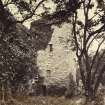
This tower-house is in good state of repair, is in occupation and is the property of Lord Wemyss. The outbuildings are in ruins.
Resurveyed at 1/2500.
Visited by OS (JLD) 15 May 1962
Desk Based Assessment (1964)
(NT 2361 4048) Neidpath Castle (NR)
OS 6" map (1965)
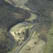
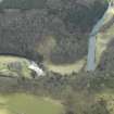
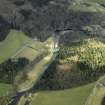
Neidpath Castle. The earliest portion of the castle is the massive L- shaped tower house, which was probably erected towards the end of the 14th century. Few alterations seem to have been made to it until the late 16th or early 17th century, when the two upper floors were remodelled. Other reconstructions were made at some time between 1653-86. There is no evidence of an original barmkin, the oldest portion of the existing courtyard buildings being the S part of the E range. This range was remodelled in the later 17th century alterations, and other alterations made in the first half of the 18th century. The S range has been remodelled comparatively recently, but some older work survives. Considerable traces of a terraced garden lay-out may be seen E of the castle; it is on record in 1581. Some traces of old enclosure walls can also be seen in South Park Wood, on the opposite side of the Tweed from the castle, an area which is locally said to be the site of a former deer park.
RCAHMS 1967, visited 1964
Information from Ordnance Survey Index Card.
Publication Account (1985)
Until the 16th century, the lands of Ne id path seem to have been called 'Jedderfield'. They were acquired by the Hays of Yester from the Frasers of Oliver about 1310, and the castle was probably begun in the late 14th century. It tops a steep rocky crag towering above the Tweed, and commands the river near to where it emerges from a wooded gorge. Given the shape of the site, the main block takes the form of a parallelogram rather than a rectangle.
But essentially Neidpath is an L-shaped tower-house, where the extra wing on each floor made for more flexible use. Though sub-divided overall into five storeys, structurally the tower was divided into just three high compartments, each barrel-vaulted in stone. The great hall characteristically occupied the entire first floor; its attendant kitchen and services filled the first-floor wing, whilst smaller rooms were built ingeniously into the thickness of the walls. At basement level, the main block was available for storage; the wing contained a pit-prison. A number of stones in the tower, up to first-floor level, bear the marks-a kind of signature-of the masons who worked them.
Few alterations seem to have be~n made for some 300 or so years, until the upper parts were remodelled in the late 16th-early 17th century; major internal reconstruction, however, was carried out in the second half of the 17th century and parts of the older 16th century courtyard buildings emodelled. The keystone of the 17th century forecourt gateway encorporates 'the crest of the Hays, Earls ofTweeddale-a goat's head upon a coronet.
The "gairdene ofneidpeth" is recorded in 1581, and the surviving parallel terraces may date from this or a slightly earlier period. Although their retaining walls are ruinous, considerable traces survive to the east of the castle running down towards the river-and the approach road itself keeps to one. The gardens went out of use around the end of the 18th century.
Information from 'Exploring Scotland's Heritage: Lothian and Borders', (1985).
Sbc Note
Visibility: This is an upstanding building.
Information from Scottish Borders Council.
Dendrochronology
NT 23618 40487 Two areas of oak timbers in Neidpath Castle were sampled for the SE Scotland Oak Dendrochronology (SESOD) research project, in the upper storey and in the basement ceiling. In the upper storey, analysis showed the common rafter oak roof was built largely with southern Norwegian timber. One of the dated roof timbers had intact sapwood and was felled in the winter of AD 1551–52. Some joists in the upper storey, which are structurally separate from the common rafter roof frames, were dated and are also 16th-century imported material; one in the southern room was felled in Norway in AD 1565. At least some of the joists are re-used and therefore were probably installed well after that date. The ceiling joists in the basement proved to be native oak, a very rare find, and a significant one for SESOD, the objective being to expand the native oak chronology coverage for SE Scotland. The felling dates of AD 1412–13 and 1414–15 for the basement ceiling oak joists date an early construction phase of the present Neidpath Castle, when the dividing timber floor was built into the lowest barrel-vaulted stone structure. The timber is probably local. Full details of these and other SESOD
results will be given in the project publication. See also the SESOD overview (p6).
Archive: NRHE (intended)
Funder: Historic Environment Scotland
Coralie M Mills – Dendrochronicle
(Source: DES Volume 23)

